
Siberia facts for kids
Quick facts for kids
Siberia
Сибирь
|
|
|---|---|

Siberian Federal District |
|
| Continent | Asia |
| Country | Russia |
| Parts |
|
| Area | |
| • Total | 13,100,000 km2 (5,100,000 sq mi) |
| Population
(2023)
|
|
| • Total | 36.8 million |
| • Density | 2.8/km2 (7/sq mi) |
| Demonym(s) | Siberians |
Siberia (pronounced sy-BEER-ee-ə; in Russian: Сибирь, Sibir) is a huge area of land in North Asia. It stretches from the Ural Mountains in the west all the way to the Pacific Ocean in the east. Siberia has been part of Russia for a long time. Russia began taking control of Siberia in the late 1500s. This happened after the Khanate of Sibir fell. The process finished when Chukotka was added in 1778.
Siberia is very large but does not have many people. It covers over 13.1 million square kilometers (5.1 million square miles). This is about 9% of Earth's land. But only one-fifth of Russia's people live there. The biggest cities in Siberia are Novosibirsk, Omsk, and Chelyabinsk.
Siberia is a geographical and historical idea, not a political one. So, its exact borders can be different depending on who you ask. Usually, it includes all the land from the Ural Mountains to the Pacific Ocean. It also includes most of the land that drains into the Arctic Ocean. Siberia stretches from the Arctic Circle in the north to the borders of Kazakhstan, Mongolia, and China in the south. The Russian government divides the region into three main parts. Only the middle part is officially called "Siberian." The other two are the Ural and Far Eastern districts.
Siberia is famous for its very cold and long winters. The average temperature in January is about -25°C (-13°F). Even though Siberia is in Asia, Russian people have moved there since the 1500s. This has made the region culturally European. More than 85% of its people are of European background. Most of these are Russians. But there are also many Asian groups living there. These include Turkic peoples like the Yakuts and Tuvans. There are also Mongolic peoples like the Buryats.
Contents
What's in a Name?
The exact origin of the name "Siberia" is not fully known. Some people think it comes from the Siberian Tatar language. In that language, "Sib ir" means "sleeping land." The name became common in Russian after Russia took over the Khanate of Sibir.
Another idea is that the region was named after the Sibe people. They are an indigenous group. One historian thought the name came from a proto-Slavic word for "north" (север, sever). But others disagree. They say that nearby Chinese, Turks, and Mongolians would not have known Russian. They suggest the name might combine two Turkic words: "su" (water) and "bir" (wild land).
Siberia's Past
Ancient Times

About 251 million years ago, huge volcanic eruptions created the Siberian Traps. These eruptions lasted for a million years. Some scientists believe they caused the "Great Dying." This event killed about 90% of all species on Earth.
Siberia is important for finding ancient animal remains. Many prehistoric animals from the Pleistocene Ice Age have been found preserved in ice. These include woolly mammoths, woolly rhinoceroses, and cave lion cubs. Wrangel Island and the Taymyr Peninsula were the last places where woolly mammoths lived. They died out around 2000 BC.
About 40,000 years ago, at least three types of humans lived in Southern Siberia. These were H. sapiens (modern humans), H. neanderthalensis (Neanderthals), and Denisovans. DNA evidence in 2010 showed that Denisovans were a separate human species.
Early History and Nomads
Over thousands of years, many nomadic groups lived in different parts of Siberia. These included the Huns, Xiongnu, and Scythians. The Mongol Empire conquered a large part of Siberia in the 13th century.
After the Mongol Empire broke apart, the Khanate of Sibir formed in the late 1400s. Siberia remained a place with very few people. One historian believes that less than 300,000 people lived there in early modern times.
Russian Expansion


In the 16th century, Russia started to become more powerful. Russian traders and Cossacks began to enter Siberia. The Russian army built forts further east to protect new Russian settlers. Towns like Tobolsk grew, and it became the main city of Siberia from 1590. By the mid-1600s, Russia controlled land all the way to the Pacific Ocean. By 1709, about 230,000 Russians had moved to Siberia.
Siberia also became a place where people were sent away from their homes as punishment. This was a common practice in Russia. Over 800,000 people were exiled there in the 1800s.
A big change for Siberia was the building of the Trans-Siberian Railway between 1891 and 1916. This railway connected Siberia more closely to Russia's growing industries. Millions of Russians moved to Siberia from Europe during this time. Siberia has many natural resources. In the 20th century, these resources were used a lot, and new industrial towns appeared.
On June 30, 1908, the Tunguska event happened in central Siberia. Millions of trees were knocked down. Most scientists think this was caused by a meteor or comet exploding in the air. No crater was found, but the land still shows signs of this huge event.
Soviet Era

During the early years of the Soviet Union, especially in the 1930s and 1940s, the government used a system of forced labor camps called the Gulag. Many of these camps were in Siberia. Millions of people were sent to these camps. Many more were forced to move to remote areas of the Soviet Union.
Many Gulag camps were in very remote parts of northeastern Siberia. Large industrial cities in Northern Siberia, like Norilsk and Magadan, grew from camps built by prisoners. These cities were later run by former prisoners.
Siberia's Landscape


.jpg)
Siberia covers about 13.1 million square kilometers (5.1 million square miles). This is most of Russia's land. It is in Asia, but because it's part of Russia, it's seen as culturally European. Key geographical areas in Siberia include the West Siberian Plain and the Central Siberian Plateau.
Eastern and central Sakha has many mountain ranges. These mountains can be almost 3,000 meters (9,800 feet) high. Above a certain height, they have almost no plants. The Verkhoyansk Range had many glaciers in the past. But the climate was too dry for glaciers to form at lower levels. In these lower areas, there are deep valleys. Many of them are covered with larch forests. In the far north, tundra takes over. The soil is often frozen deep down, called permafrost.
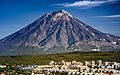
The highest point in Siberia is an active volcano called Klyuchevskaya Sopka. It is on the Kamchatka Peninsula. Its peak is 4,750 meters (15,584 feet) high.
Mountain Ranges in Siberia
- Altai Mountains
- Chersky Range
- Kolyma Mountains
- Sayan Mountains
- Ural Mountains
- Verkhoyansk Range
Major Rivers and Lakes
- Lake Baikal (the deepest freshwater lake in the world)
- Lena River
- Ob River
- Yenisey River
- Irtysh River
- Kolyma River
Siberia's Geology
The West Siberian Plain is mostly flat. It was formed by deposits from ancient rivers. This area is very swampy. In the south, where there is no permafrost, there used to be rich grasslands.
The Central Siberian Plateau is a very old landmass. It was once its own continent. This area is full of valuable minerals. It has huge amounts of gold, diamonds, nickel, and other metals. It also has large amounts of oil and natural gas. A huge volcanic event, called the Siberian Traps, happened here. It was one of the biggest volcanic eruptions in Earth's history. Much of this area has very deep permafrost. The only tree that grows well here is the Siberian Larch. Its roots are very shallow.
Siberia's Climate
_4Y1A8757_(28363120875).jpg)
 |
|
polar desert tundra alpine tundra taiga montane forest |
| Most of Siberia is covered by taiga forests. There is a tundra belt in the north. |
Siberia's climate changes a lot, but it usually has short summers and very cold winters. Along the northern coast, inside the Arctic Circle, summer lasts only about one month.
Most people live in the south, near the Trans-Siberian Railway. The climate here has cold winters but warm summers that last at least four months. The average yearly temperature is about 0.5°C (33°F). January averages about -20°C (-4°F), and July averages about +19°C (66°F). Summer daytime temperatures often go above 20°C (68°F). With good soil and sunshine, southern Siberia is good for farming.
The most common climate in Siberia is subarctic. The average yearly temperature is about -5°C (23°F). January averages about -25°C (-13°F), and July averages about +17°C (63°F). However, this can vary a lot.
Two towns in Siberia, Verkhoyansk and Oymyakon, compete for the title of the Northern Hemisphere's "Pole of Cold." This means they are the coldest inhabited places in the Northern Hemisphere. In 1933, Oymyakon recorded a temperature of -67.7°C (-89.9°F). Verkhoyansk recorded -69.8°C (-93.6°F) for three nights in 1933. Both towns can also reach 30°C (86°F) in summer. This gives them some of the biggest temperature differences between summer and winter in the world.
Southwesterly winds bring warm air from Central Asia. West Siberia (like Omsk) is a few degrees warmer than East Siberia (like Irkutsk). The Sakha Republic is the coldest Siberian region. The Yana river basin has the lowest temperatures of all. Here, permafrost can be 1,493 meters (4,900 feet) deep.
Siberia generally gets little rain or snow. Only Kamchatka gets more than 500 mm (20 inches) of precipitation. This is because moist winds from the Sea of Okhotsk hit high mountains there. This creates the region's only major glaciers.
Climate Change in Siberia
Scientists are concerned that Western Siberia has started to thaw due to global warming. The frozen peat bogs in this area hold billions of tons of methane. Methane is a powerful greenhouse gas that traps heat in the atmosphere. If it is released, it could speed up global warming. In 2008, researchers found methane levels up to 100 times higher than normal over the Siberian Arctic. This was likely from methane trapped under the frozen seabed.
Animals of Siberia
Birds
_(26738644457).jpg)
Many types of birds live in Siberia. Some common ones include:
- Hazel grouse
- Siberian grouse
- Black grouse
- Western capercaillie
- Willow ptarmigan
- Rock ptarmigan
- Daurian partridge
- Grey partridge
Mammals


Siberia is home to many different mammals, including:
- Moose
- Bactrian camel
- Wisent (European bison)
- Red deer
- Wild boar
- Siberian roe deer
- Siberian musk deer
- Grey wolf
- Arctic fox
- Red fox
- Snow leopard
- Amur leopard
- Siberian tiger
- Eurasian lynx
- Pallas's cat
- Sable
- Wolverine
- Brown bear
- Polar bear
Plants of Siberia

Siberia has vast forests. Some of the important trees found here are:
- Larix sibirica (Siberian Larch)
- Larix gmelinii
- Picea obovata (Siberian Spruce)
- Pinus pumila (Siberian Dwarf Pine)
Siberia's Government and History
Important States in Siberia's History
Siberia has been part of many different states throughout history. Here are some of them:
- Mongol Empire (13th–14th century)
- Khanate of Sibir (1468–1598)
- Tsardom of Russia (1598–1721)
- Russian Empire (1721–1917)
- Soviet Union (1922–1991)
- Russian Federation (1991–present)
Borders and Regions


The idea of "Siberia" has changed over time. Historically, it meant all of Russia east of the Ural Mountains, including the Russian Far East. This definition included land from the Urals to the Pacific coast. It also stretched from the Arctic Ocean south to the borders of Central Asia, Mongolia, and China.
Today, Russian sources usually define Siberia as the region east of the Ural Mountains. It goes up to the watershed (the line where rivers flow to different oceans) between the Pacific and Arctic Oceans. It stretches south from the Arctic Ocean to the borders of Kazakhstan, Mongolia, and China. This definition includes the Siberian Federal District and parts of the Ural Federal District. It also includes the Sakha Republic, which is part of the Far Eastern Federal District.
Some people use a wider definition that includes the entire Russian Far East. Others use a narrower one that only includes the Siberian Federal District. People who live in the Siberian Federal District often call themselves "Siberian."

| Subject | Administrative center |
|---|---|
| Ural Federal District | |
| Khanty-Mansiysk | |
| Kurgan | |
| Tyumen | |
| Salekhard | |
| Siberian Federal District | |
| Barnaul | |
| Gorno-Altaysk | |
| Irkutsk | |
| Abakan | |
| Kemerovo | |
| Krasnoyarsk | |
| Novosibirsk | |
| Omsk | |
| Tomsk | |
| Kyzyl | |
| Far Eastern Federal District | |
| Ulan-Ude | |
| Yakutsk | |
| Chita | |


.JPG)
Major Cities in Siberia
Novosibirsk is the largest city in Siberia. It is also the third largest city in all of Russia. Today, Novosibirsk is a key center for business, science, and culture in Asian Russia.
Omsk was important during the Russian Civil War. It was a temporary capital of Russia. It also played a role in Russia's expansion into Central Asia. Now, Omsk is a major center for oil refining, education, and transportation.
Other old and important cities in Siberia include Tobolsk, Tomsk, and Irkutsk. Tobolsk was the first capital of Siberia. Tomsk was once a rich merchant town. Irkutsk is near Lake Baikal.
Other big cities are Barnaul, Kemerovo, Krasnoyarsk, Novokuznetsk, and Tyumen.
Siberia's Economy

Novosibirsk is the most important city for Siberia's economy. Omsk is the second largest city. Since the 1950s, Omsk has had Russia's largest oil refinery.
Siberia is incredibly rich in minerals. It has huge amounts of almost every valuable metal. It has some of the world's largest deposits of nickel, gold, lead, coal, diamonds, silver, and zinc. It also has large, untouched amounts of oil and natural gas. About 70% of Russia's known oil fields are in the Khanty-Mansiysk region. Norilsk Nickel is the world's biggest producer of nickel and palladium.
Farming in Siberia is limited because of the short growing season. But in the southwest, the soil is very fertile. Here, farmers grow wheat, barley, and potatoes. They also raise many sheep and cattle. In other areas, food production is mostly reindeer herding in the tundra. Native people have done this for over 10,000 years.
Siberia has the world's largest forests. Selling timber is still a big source of money. However, many forests in the east have been cut down too quickly. The Sea of Okhotsk is one of the richest fishing areas in the world. This is due to its cold currents. Siberia produces over 10% of the world's yearly fish catch.
Sports in Siberia

Bandy is Russia's third most popular sport, and it's very important in Siberia. In the 2015–16 season, Yenisey from Krasnoyarsk won the Russian Bandy Super League. They beat Baykal-Energiya from Irkutsk. Other Siberian teams also play in the Super League. In 2007, Kemerovo got Russia's first indoor arena built just for bandy. Now, Khabarovsk has the world's largest indoor bandy arena, Arena Yerofey.
Krasnoyarsk hosted the 2019 Winter Universiade, which is a big international sports event for university students.
People of Siberia

| Ethnicity | Population | % |
|---|---|---|
| Slavic | 18,235,471 | 86.2% |
| Turkic | 1,704,665 | 8.1% |
| Mongol | 454,312 | 2.1% |
| Uralic | 131,430 | 0.6% |
| Other | 637,992 | 3.0% |
According to the 2010 Russian Census, about 25.6 million people live in the Siberian and Far Eastern Federal Districts. If you include other parts of Siberia, the total population is around 30 million people. This means there are about three people per square kilometer.
The largest group of people in Siberia are Russians of Slavic origin. This includes a group called Siberians and also Ukrainians who have moved to Siberia. Slavic and other European groups make up most of the population (over 85%). There are also many indigenous Siberian groups and other ethnic groups.
Some of the indigenous groups include the Mongol-speaking Buryats, who number about 500,000. They mostly live in their homeland, the Buryat Republic. There are also about 478,085 Turkic-speaking Yakuts. Other indigenous groups include Kets, Evenks, and Chukchis.
About 70% of Siberia's people live in cities, mostly in apartments. Many also live in rural areas in large, simple log houses. Novosibirsk is the biggest city, with about 1.6 million people. Tobolsk, Tomsk, Tyumen, Krasnoyarsk, Irkutsk, and Omsk are older, historical centers.
Religions in Siberia

Many different beliefs are found across Siberia. These include Orthodox Christianity, other Christian groups, Tibetan Buddhism, and Islam. The Siberian Federal District alone has an estimated 250,000 Muslims.
About 70,000 Jewish people live in Siberia. Some live in the Jewish Autonomous Region. The main religion is the Russian Orthodox Church.
Siberia is also known as the original home of shamanism. This is a belief system where spiritual leaders called shamans connect with the spirit world. Many native tribes practice polytheism, which means believing in many gods. These ancient practices are very important to the tribes. There are records of Siberian healing practices from the 13th century. Siberia has many local traditions with different gods and sacred places, like Olkhon Island in Lake Baikal.
Getting Around Siberia
Many cities in northern Siberia, like Petropavlovsk-Kamchatsky, cannot be reached by road. There are almost no roads connecting them to other major cities in Russia. You can reach Siberia using the Trans-Siberian Railway. This railway runs from Moscow in the west to Vladivostok in the east. Cities far from the railway can be reached by air or by the separate Baikal–Amur Mainline (BAM) railway.
Siberian Culture
Food
Stroganina is a traditional dish of the native people in northern Arctic Siberia. It is made from raw, thinly sliced frozen fish. It's a popular food for native Siberians. Siberia is also known for its pelmeni dumplings. In winter, these are often frozen and stored outside. People also enjoy many dishes made from berries, nuts, and mushrooms found in nature.
Images for kids
-
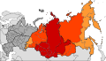
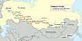
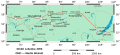
Map of Siberia showing federal districts.
-
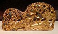
Horseman hunting, Southern Siberia, 280–180 BCE.
-
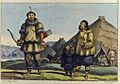
Chukchi family by Louis Choris (1816).
-
Coat of arms of Siberia, used until 1917.
-
Map of the Siberian Route in the 18th and early 19th centuries.
-
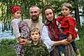
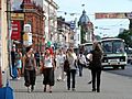
Siberian Cossack family in Novosibirsk.
-
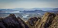
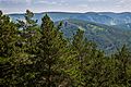
View from Haiyrakan mountain, Tuva.
-
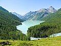
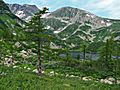
Altai, Lake Kutsherla in the Altai Mountains.
-
The peninsula of Svyatoy Nos, Lake Baikal.
-
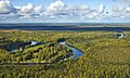
The river Vasyugan in the southern West Siberian Plain.
-
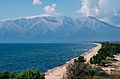
Koryaksky volcano towering over Petropavlovsk-Kamchatsky on the Kamchatka Peninsula.
-
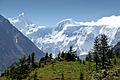
Belukha Mountain.
-
Siberian taiga.
-
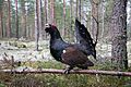
Capercaillies occupy much of the Siberian taiga.
-
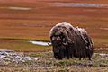
A muskox on Bolshoy Begichev Island in Laptev Sea.
-
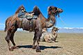
Two saddled Bactrian camels shedding their coat in the Altai mountain range.
-
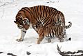
A Siberian tigress and cub.
-
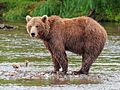
Kamchatka brown bear at Kamchatka Peninsula.
-
Siberian larch Larix sibirica trees in summer. Kuznetsk Alatau Nature Reserve, Kemerovo Oblast.
-
Map of the most populated area of Siberia with clickable city names (SVG).
-
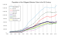
Comparison of the nine biggest Siberian cities' growth in the 20th century.
-
Novosibirsk is the largest city in Siberia.
-
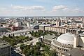
Amur waterfront in Khabarovsk.
-
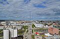
Yakutsk is the capital of the Sakha Republic.
-

KHL game HC Sibir Novosibirsk vs Amur Khabarovsk.
-
Tomsk, one of the oldest Siberian cities, was founded in 1604.
-
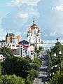
Transfiguration Cathedral, Khabarovsk.


See also
 In Spanish: Siberia para niños
