
Central Siberian Plateau facts for kids
Quick facts for kids Central Siberian Plateau |
|
|---|---|
| Среднесиби́рское плоского́рье | |

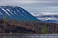
View of the Lower Tunguska River on the Central Siberian Plateau
|
|

Location in Russia
|
|
| Location | Krasnoyarsk Krai Sakha Republic Irkutsk Oblast |
| Coordinates | 64°N 103°E / 64°N 103°E |
| Part of | Siberia |
| Elevation | 1,678 meters (5,505 ft) (highest) |
| Length | 2,000 kilometres (1,200 mi) |
| Width | 2,000 kilometres (1,200 mi) |
| Area | 3,500,000 km2 (1,400,000 sq mi) |
| Geology | Plateau |
The Central Siberian Plateau is a huge, flat, high area of land in Siberia, Russia. It is one of the largest landforms in Russia. This plateau is known for its vast forests and rich natural resources.
Geography
This large plateau covers a big part of central Siberia. It sits between two major rivers: the Yenisei in the west and the Lena in the east. The plateau stretches over a massive area of about 3.5 million square kilometers.
To the south, it is bordered by several mountain ranges. These include the Altai Mountains, Sayan Mountains, and Baikal Mountains. To the north, you'll find the North Siberian Lowland. To the east, the plateau gradually changes into the Central Yakutian Lowland.
The Central Siberian Plateau has many wide, flat areas. It also has sharp, jagged ridges. This huge plateau makes up about one-third of all Siberia.
Smaller Plateaus and Ranges
The Central Siberian Plateau is actually made up of many smaller plateaus and mountain ranges. Here are some of the most important ones:
- Putorana Plateau: This is in the northwest. It has the highest point of the entire plateau system, Mount Kamen, which is 1,678 meters tall.
- Anabar Plateau: Located at the northern end, its highest point is 905 meters.
- Vilyuy Plateau: Its highest point reaches 962 meters.
- Syverma Plateau: The highest point here is Nakson, at 1,035 meters.
- Tunguska Plateau: This plateau's highest point is 866 meters.
- Lena Plateau: Its highest point is 700 meters.
- Lena-Angara Plateau: The highest point, Namai, is 1,509 meters.
- Yenisei Range: This range has a highest point of 1,125 meters.
- Angara Range: Its highest point is 1,022 meters.
Climate and Resources
The Central Siberian Plateau has a continental climate. This means it has short, warm summers. The winters are very long and extremely cold. Most of the land is covered with thick conifer forests. Larch trees are especially common here.
The main river flowing through the plateau is the Lower Tunguska. This region is also incredibly rich in mineral resources. You can find many valuable minerals here. These include coal, iron ore, gold, platinum, diamonds, and natural gas.
See also
 In Spanish: Meseta central siberiana para niños
- Economy of Russia — Natural resources
- South Siberian Mountains
- Tunguska event
- Udachnaya pipe
Images for kids
-
Landscape of the Putorana Nature Reserve.
-
Gold on arsenopyrite as found in the Yenisei Range.


