
Petropavlovsk-Kamchatsky facts for kids
Quick facts for kids Petropavlovsk-Kamchatsky (English)Петропавловск-Камчатский (Russian) |
|
|---|---|
| - City - | |
 Aerial view of Petropavlovsk-Kamchatsky with the Koryaksky volcano at left |
|
 |
|
|
|
|
| City Day | 17 October |
| Administrative status | |
| Country | Russia |
| Federal subject | Kamchatka Krai |
| Administratively subordinated to | Petropavlovsk-Kamchatsky City Under Krai Jurisdiction |
| Municipal status | |
| Urban okrug | Petropavlovsk-Kamchatsky Urban Okrug |
| Head | Konstantin Bryzgin |
| Representative body | City Duma |
| Statistics | |
| Area | 362.15 km2 (139.83 sq mi) |
| Population (2010 Census, preliminary) |
179,780 inhabitants |
| - Rank in 2010 | 100th |
| Population (2021 est.) | 164,900 inhabitants |
| Density | 496/km2 (1,285/sq mi) |
| Time zone | MAGT (UTC+12:00) |
| Founded | 17 October 1740 |
| Postal code(s) | 683000 (main) |
| Dialing code(s) | +7 4152 |
| Official website: http://pkgo.ru/ | |
Petropavlovsk-Kamchatsky (Russian: Петропавловск-Камчатский) is a major city in Russia. It is the main city of Kamchatka Krai. You can find it in the far eastern part of the country. The city sits right on the coast of Avacha Bay, which is part of the Pacific Ocean. In 2021, about 164,900 people lived there.
People often call the city simply Petropavlovsk. This name means "city of Peter and Paul". The word Kamchatsky was added in 1924. It means "from Kamchatka," showing where the city is located.
History of Petropavlovsk-Kamchatsky
How the City Started
Cossack groups first visited this area in 1697. The city was officially founded in 1740 by Captain Vitus Bering. He was an explorer and navigator from Denmark, working for Russia. Another navigator, Ivan Fomich Yelagin, had actually started building a few months earlier.
Bering arrived at Avacha Bay in late 1740. He named the new settlement "Petropavlovsk." He chose this name after his two ships, the Saint Peter and the Saint Paul. These ships were built for his second big expedition. The city's location was perfect. It was on the eastern coast of the Kamchatka Peninsula. It also had a safe harbor in Avacha Bay and was near the Avacha River. Because of this, it grew into the most important place in Kamchatka. It officially became a town on April 9, 1812.
The Crimean War Battle
During the Crimean War (1853–1855), forces from Britain and France tried to attack Petropavlovsk. This event is known as the Siege of Petropavlovsk in August and September 1854. However, the city was never captured.
The city had been made stronger by Nikolay Muravyov before the war. It had only a small group of soldiers and 67 cannons. After a lot of fighting, 600 British and French soldiers landed south of the city. But 230 Russian soldiers fought hard and made them leave on September 1, 1854. Four days later, a larger group of 900 British and French soldiers landed east of the town. Again, the Russians pushed them back on September 5, 1854. The enemy ships then left the Russian Pacific waters. The Russians lost about 100 men. The British and French lost more than twice that number, with 209 men.
After World War II
After World War II ended in 1945, a group of US Navy builders called Seabees came to the area. They built a special weather station for the Navy near Petropavlovsk-Kamchatsky. This project was agreed upon by Stalin, the leader of the Soviet Union. The Seabees finished building the camp very quickly. However, the American use of this base did not last long.
Petropavlovsk was a very important place for fishing in the 20th century. It provided a lot of salmon and crab meat for the Soviet Union. After the Soviet Union ended in 1991, other countries were also allowed to fish here. Unfortunately, illegal fishing of salmon for their caviar is still a problem.
2020 Earthquake Event
On March 25, 2020, a strong earthquake with a magnitude of 7.5 happened. It was the biggest earthquake in Russia since 2013. Even though Petropavlovsk-Kamchatsky was 460 kilometers (285 miles) away from where it hit, people still felt it strongly. Objects fell inside buildings, and many people ran outside for safety.
Geography of Petropavlovsk-Kamchatsky
City Location and Surroundings
The city is located at sea level. It is surrounded by many volcanoes. The land around the city is very mountainous. Because of this, you cannot see the horizon clearly from anywhere in town.
Across Avacha Bay from the city, in Vilyuchinsk, is Russia's largest submarine base. This base, called Rybachiy Nuclear Submarine Base, was built during the Soviet era. The Russian Navy still uses it today. The city is very far from Moscow, about 6,766 kilometers away. It is also about 2,220 kilometers from Vladivostok.
Climate and Weather
Petropavlovsk-Kamchatsky has a subarctic climate. This means it has long, cold winters and short, cool summers. However, the nearby Pacific Ocean greatly affects its weather. The city gets a lot of rain and snow, about 1,180 millimeters each year. This is much more than most of Siberia. Most of the snow falls from November to April.
Winter temperatures are not as cold as in Siberia. In January, the average daytime high is around -4.0°C (25°F). In August, the warmest month, the average daytime high is about 17°C (63°F). Summers are cooler here because of the ocean. On average, the city has about 19.6 days per summer where the temperature goes above 20°C (68°F).
The weather is less cloudy than in the nearby Kuril Islands. This is because a peninsula to the north blocks some of the fog. The water in Avacha Bay is also warmer than the coastal waters around the Kuril Islands. Sometimes, in spring (February to April), the seawater can freeze.
- Highest Temperature Ever: 30.0°C (86.0°F) on July 2, 2012
- Lowest Temperature Ever: -31.7°C (-25.1°F) on February 14, 1917
- Most Rain in One Day: 200.2 mm (7.88 inches) on November 10, 2002
- Wettest Year: 1,996 mm (78.6 inches) in 1971
- Driest Year: 432 mm (17.0 inches) in 1947
Culture and Activities
Sports and Recreation
The main association football stadium in Petropavlovsk-Kamchatsky is the Spartak Stadium. It can hold 5,000 people. A former football club called FC Volcano used to play there.
Museums to Visit
There are several museums in the city. They offer a chance to learn about the history and nature of the Kamchatka region.
Tourism and Travel
Petropavlovsk-Kamchatsky is the main starting point for exploring the rest of the Kamchatka Peninsula. Many people visit to see its unique volcanoes and nature.
Transportation in the City
The city is served by Petropavlovsk-Kamchatsky (Elizovo) Airport. This airport connects the city and its port by the A-401 road. During the warmer months, cruise ships often stop here for a day. The city also has a bus service for getting around.
Population and People
| Historical population | ||
|---|---|---|
| Year | Pop. | ±% |
| 1897 | 395 | — |
| 1926 | 1,691 | +328.1% |
| 1939 | 35,373 | +1991.8% |
| 1959 | 85,582 | +141.9% |
| 1970 | 153,885 | +79.8% |
| 1979 | 214,977 | +39.7% |
| 1989 | 268,747 | +25.0% |
| 2002 | 198,028 | −26.3% |
| 2010 | 179,780 | −9.2% |
| 2021 | 164,900 | −8.3% |
| Source: Census data | ||
Most of the people living in Petropavlovsk-Kamchatsky are Russians. The city has more people than the entire neighboring Chukotka Autonomous Okrug or Magadan Oblast.
The population was 179,780 in 2010. It was 179,800 in 2011, and 181,618 in 2013. By 2021, the population was 164,900.

In 2021, the main ethnic groups were:
|
Sister Cities Around the World
Petropavlovsk-Kamchatsky has sister city relationships with two other cities:
 Kushiro, Japan (since 1998)
 Unalaska, United States (since 1990)
Famous People from Petropavlovsk-Kamchatsky
- Pavlo Ishchenko, a boxer who competed in the Olympics for Ukraine and Israel.
- Anatolii Mohyliov, a Ukrainian politician.
- Sergei Ursuliak, a Russian filmmaker, writer, actor, and TV presenter.
- Elena Yakovishina, a Russian Olympic skier.
- Igor Smirnov, the first president of Transnistria.
- Regina Sych, a Russian swimmer.
- Innokenty Omulevsky, a Russian writer.
- Aleksandra Frantseva, a Russian alpine skier.
- Viktor Borel, a Belarusian football coach and former player.
- Artem Ansheles, an actor from Hong Kong.
Images for kids
-
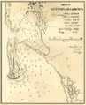
A map of Petropavlovsk harbor from 1872.

See also
 In Spanish: Petropávlovsk-Kamchatski para niños
