
Kamchatka Krai facts for kids
Quick facts for kids Kamchatka KraiКамчатский край (Russian) |
|||||
|---|---|---|---|---|---|
| — Krai — | |||||
|
|||||
|
|||||
| Political status | |||||
| Country | Russia | ||||
| Federal district | Far Eastern Federal District | ||||
| Economic region | Far Eastern Economic Region | ||||
| Established | July 1, 2007 | ||||
| Administrative center | Petropavlovsk-Kamchatsky | ||||
| Government (as of June 2015) | |||||
| • Governor | Vladimir Ilyukhin | ||||
| • Legislature | Legislative Assembly of Kamchatka Krai | ||||
| Statistics | |||||
| Area (as of the 2002 Census) | |||||
| • Total | 472,300 km2 (182,400 sq mi) | ||||
| Area rank | 10th | ||||
| Population (2010 Census) | |||||
| • Total | 322,079 | ||||
| • Rank | 76th | ||||
| • Density | 0.68/km2 (1.8/sq mi) | ||||
| Population (January 2015 est.) | |||||
| • Total | 317,206 | ||||
| Time zone(s) | MAGT (UTC+12:00) | ||||
| ISO 3166-2 | RU-KAM | ||||
| License plates | 41, 82 | ||||
| Official languages | Russian | ||||
| Official website: http://www.kamchatka.gov.ru | |||||


Kamchatka Krai is a special part of Russia, located far away in the eastern part of Asia. It's one of 85 areas that make up Russia, and it's part of the Far Eastern Federal District, which has ten other similar regions.
Contents
Kamchatka's Past: A Look at Its History
For a long time, the Koryak people lived in Kamchatka. They were the first known inhabitants of this land. In the 1600s, Russian explorers arrived. But the cold weather and tough land made it hard to explore.
Early Conflicts and Changes
During the 1700s, there were many fights between the native people and the Russians. This happened because the Russian Tsar (emperor) wanted more of the area explored. A terrible disease called smallpox spread in 1768-1769. It sadly wiped out most of the native population.
In 1854, Kamchatka saw fighting during the Crimean War. This was between the Russians and the British and French. Later, in 1867, Russia sold Alaska to the United States. Kamchatka then became less important for travelers.
Kamchatka in Modern Times
Towards the end of World War II, Kamchatka was a key place for Soviet troops. They used it to plan an invasion of Japan. After the war, the area became a military zone. It was closed to most people until 1990 for Russians and 1991 for foreigners. Today, Kamchatka remains a Krai (a type of federal region) within Russia.
Kamchatka's Amazing Geography
.jpg)
Kamchatka is in the far eastern part of Siberia. It has a subarctic climate. This means it has very long, cold winters and short, mild summers. It gets more rain than other parts of Eastern Siberia. This is because winds blow in from the Sea of Japan.
Mountains and Volcanoes
The land is mostly mountainous. The Sredinny Mountain Range covers a large part of the region. This range has the most glaciers in North-East Asia. Kamchatka also has many active volcanoes. These volcanoes are so special that they are a UNESCO World Heritage Site.
The area often has volcano eruptions and earthquakes. This is because it sits on the Pacific Ring of Fire. This is a zone where many earthquakes and volcanic eruptions happen.
Wildlife and Nature
Kamchatka has a lot of different animals, birds, and plants. This is due to its good climate, varied land, and small human population. It's a great place for nature lovers.
Who Lives in Kamchatka? Demographics
After the Soviet Union ended, Kamchatka's population went down for a while. But now, it is growing again. Most people live in cities and towns. The capital city, Petropavlovsk-Kamchatsky, is where many people live.
People and Languages
Most people in Kamchatka are Russian. Only a small number are ethnic Koryaks or other native groups. Most people practice Orthodox Christianity. Some people do not follow any religion.
Some native people still practice Shamanism. This is a belief system that worships spirits and nature. Russian is the main language taught and used in Kamchatka. Native languages like Koryak, Itelmen, or Chuvan are rarely taught or spoken at home.
Kamchatka's Economy: How People Make a Living
Kamchatka's economy mostly relies on fishing. It also depends on processing natural resources. These resources include wood, coal, and gold. This means the lumber and mining industries are important.
Trade and Shipping
Kamchatka is located along major shipping routes. This allows it to offer services like building and repairing ships. It also helps move goods between ships. In the past, Kamchatka was part of the fur trade. This trade connected it with places like China and Alaska.
How Kamchatka is Governed: Politics
The Governor of Kamchatka is the main leader of the Krai. People vote for the Governor every five years. The Kamchatka Legislative Assembly is like the region's parliament. Its lawmakers are also chosen by public vote every five years.
Most lawmakers in the Legislative Assembly are from the United Russia party. This party is the main ruling party in Russia. Kamchatka Krai was formed on July 1, 2007. It was created by joining Kamchatka Oblast and Koryak Autonomous Okrug.
Getting Around Kamchatka: Transportation
Kamchatka is quite far away from the rest of Russia. There are no railways or roads that connect it to other parts of the country. Flying is the easiest way to get in or out of Kamchatka.
Air and Sea Travel
There are several airports, like the Yelizovo Airport. Flights from these airports connect Kamchatka to cities further away in Russia. However, there are no international flights directly into the area. Kamchatka is also on important shipping routes. These routes connect it by sea with Alaska and East Asia.
Images for kids
-
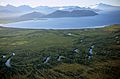
Lake Kronotskoye
-
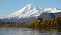
Kambalny stratovolcano
-
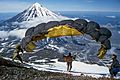
Koryaksky volcano
-
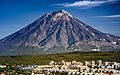
Koryaksky volcano towering over Petropavlovsk-Kamchatsky


.jpg)
See also
 In Spanish: Krai de Kamchatka para niños
