
Arctic Circle facts for kids

The Arctic Circle is a special imaginary line on Earth. It is one of the two polar circles, found in the northern part of our planet. You can see it on maps at about 66° 34' North. Its twin in the south is called the Antarctic Circle.
This line is important because it marks the southernmost place where, once a year, the Sun either stays above the horizon for a full 24 hours (the midnight sun) or stays below the horizon for a full 24 hours (the polar night). These amazing events happen around the June solstice (summer) and the December solstice (winter). The closer you get to the North Pole, the longer these periods of endless day or night last. For example, in Murmansk, Russia, the sun stays hidden for about 20 days around winter, and stays visible for about 20 days around summer.
The exact location of the Arctic Circle changes a little bit each year. Right now, it is 66°33′51.0″ north of the Equator. This movement happens because of Earth's axial tilt, which slowly changes over thousands of years. Because of this, the Arctic Circle is slowly moving towards the North Pole, about 14.5 m (48 ft) (47 feet) every year.
Contents
Where Does the Name Come From?
The word arctic comes from an old Greek word, arktikos. This word means "near the Bear" or "northern." It comes from another Greek word, arktos, which means "bear."
Days of Endless Sun and Dark Nights

The Arctic Circle is the lowest latitude in the Northern Hemisphere where the Sun can stay above or below the horizon for a full 24 hours. This means that at least once a year, if you are inside the Arctic Circle, you can see the Sun at midnight. Also, at least once a year, the Sun won't be visible at noon.
Right on the Arctic Circle, these events happen once a year, during the June solstice and December solstice. However, because light bends in the air (this is called atmospheric refraction) and because the Sun looks like a big disk, not just a tiny point, you can sometimes see a bit of the midnight sun even a little south of the Arctic Circle. The same is true for the polar night; you might see a tiny bit of the sun even a little north of the line. This is true at sea level, and these limits can change if you are high up in the mountains.
Life in the Far North

Many people live north of the Arctic Circle. The biggest cities are in Russia, Norway, and Sweden. Some of these include Murmansk (with about 295,374 people) and Norilsk (178,018 people) in Russia. In Norway, you'll find Tromsø (75,638 people). Kiruna, Sweden, has about 22,841 residents. Rovaniemi, Finland, is very close to the Arctic Circle, just 6 km (4 mi) south of it, and has 62,667 people. Salekhard in Russia, with 51,186 people, is the only city directly on the Arctic Circle.
In North America, the largest town north of the Arctic Circle is Sisimiut in Greenland, with about 5,600 people. In the United States, Utqiagvik, Alaska (also known as Barrow) has about 5,000 residents. Canada's largest community in this region is Inuvik in the Northwest Territories, with 3,137 people.
Who Owns the Arctic Waters?
The Arctic region includes land, lakes, and parts of the ocean north of the Arctic Circle. Eight countries have land within this circle: Canada, the Kingdom of Denmark (through Greenland), Finland, Iceland, Norway, Russia, Sweden, and the United States.
Under international law, the North Pole and the deep waters of the Arctic Ocean around it are not owned by any single country. However, the countries bordering the Arctic (Canada, Denmark, Norway, Russia, and the U.S.) have special rights over the waters and seabed close to their coasts.
Exploring the Arctic Lands

The Arctic Circle is about 16,000 km (9,900 mi) (9,942 miles) long. The land and sea north of this circle cover about 20,000,000 km2 (7,700,000 sq mi) (7.7 million square miles). This is about 4% of Earth's total surface.
The Arctic Circle crosses the Arctic Ocean, the Scandinavian Peninsula, parts of North Asia, Northern America, and Greenland. The land inside the Arctic Circle belongs to eight countries: Norway, Sweden, Finland, Russia, the United States (Alaska), Canada (Yukon, Northwest Territories, and Nunavut), Denmark (Greenland), and Iceland (where it passes through the small island of Grímsey).
Arctic Weather Wonders
The weather north of the Arctic Circle is usually very cold. However, coastal areas in Norway have milder weather because of the Gulf Stream. This warm ocean current keeps ports in northern Norway and northwest Russia free of ice all year. Inland, summers can be surprisingly warm, but winters are extremely cold. For example, in Norilsk, Russia, summer temperatures can reach 30 °C (86 °F) (86°F), while winter temperatures often drop below −50 °C (−58 °F) (-58°F).
Gallery
-
Arctic Circle marker on island of Grímsey in Iceland
-
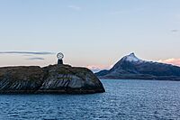
Northern Polar Circle Globe on Vikingen island marking the Arctic Circle in Norway
-
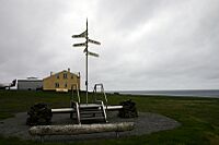
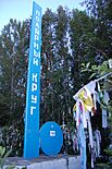
Arctic Circle sign by the Inland Line railway, Sweden
-
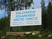
Polcirkeln portal near Nattavaara, Sweden
-
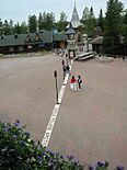
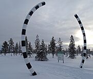
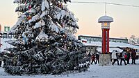
The white borderline of the Arctic Circle at the Santa Claus Village in Rovaniemi, Finland
-
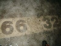
Arctic Circle line 66° 32′ 35″ in Santa Claus Village, Finland
-
Arctic Circle sign in the Republic of Karelia, Russia
-
Arctic Circle sign in the Tazovsky District, Russia
-
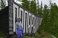
A sign near Zhigansk (Yakutia), Russia
-
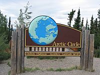
A sign along the Dalton Highway marking the location of the Arctic Circle in Alaska, United States
-
Arctic Circle near to Santa Claus Village in Rovaniemi, Finland
-
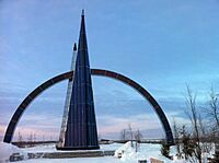
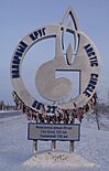
Arctic Circle monument in Salekhard, Russia
-
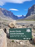
Parks Canada Arctic Circle sign in Auyuittuq National Park, Baffin Island, Nunavut, with Mount Thor in the background
-
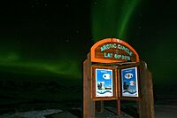
Aurora Borealis (Northern Lights) above an Arctic Circle sign in Yukon.
-
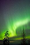
At night, bright aurora borealis are a common sight in the Arctic Circle. This picture shows the northern lights in Rovaniemi.


.jpg)


.jpg)


Related pages
- Northern Hemisphere
- Southern Hemisphere
- Eastern Hemisphere
- Western Hemisphere
- Seasons
- Solstice and equinox
- Equator
- Tropic of Cancer
- Tropic of Capricorn
- Antarctic Circle
- Circle of latitude
See also
 In Spanish: Círculo polar ártico para niños
