
Dalton Highway facts for kids
Quick facts for kids
|
||||
|---|---|---|---|---|
| James W. Dalton Highway North Slope Haul Road |
||||
|
Dalton Highway highlighted in red
|
||||
| Route information | ||||
| Maintained by Alaska DOT&PF | ||||
| Length | 414 mi (666 km) | |||
| Existed | 1974–present | |||
| Major junctions | ||||
| South end | ||||
| North end | East Lake Colleen Drive in Deadhorse | |||
| Location | ||||
| Boroughs: | Unorganized, North Slope | |||
| Highway system | ||||
Alaska Routes
|
||||

The Dalton Highway, officially known as the James W. Dalton Highway and signed as Alaska Route 11, is a very long road in Alaska. It stretches for about 414 miles (666 km) (666 km). This highway starts north of Fairbanks and goes all the way north to Deadhorse, which is close to the Arctic Ocean.
The road was built in 1974. Its main purpose was to provide a way to transport supplies for the Trans-Alaska Pipeline System. This pipeline carries oil across Alaska. Because of its remote location and tough conditions, the Dalton Highway is known as one of the most challenging roads in the world.
Contents
What is the Dalton Highway?
The Dalton Highway is mostly made of gravel. Only about 109 miles (175 km) of the road is paved. It was originally called the "North Slope Haul Road." This name came from its job of "hauling" supplies to the North Slope of Alaska.
The highway runs right next to the Trans-Alaska Pipeline System. This huge pipeline carries oil from the oil fields in northern Alaska to ports further south. Driving the Dalton Highway means you'll often see the pipeline running alongside you.
Life Along the Road
There are very few places where people live along the Dalton Highway. It's a very remote area. You'll find only three tiny towns on the entire route:
- Coldfoot has about 10 people living there.
- Wiseman has a population of around 22.
- Deadhorse has about 25 people.
Other spots like Prospect Creek and Galbraith Lake are mostly used by campers or people working on the pipeline. No one lives there permanently.
Driving the Dalton Highway
Driving on the Dalton Highway can be a big adventure. It's important to be prepared for anything. Travelers are always told to bring first aid kits and other important items for survival. This is in case of an emergency or if their vehicle breaks down.
The weather can change very quickly, and conditions can be harsh. Snow, ice, and strong winds are common, especially in winter. Even in summer, the road can be muddy or dusty. It's a journey that requires careful planning and a sense of adventure!
Images for kids
-
Sukakpak Mountain is a landmark at MP 203 Dalton Highway
-
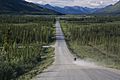
Dalton Highway south of the Continental Divide in the summer
-

Dalton Highway passing Sukakpak Mountain in the summer
-
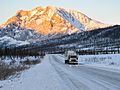
The Brooks Range south of the Continental Divide near Atigun Pass (6 March 2013)
-
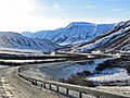
The Brooks Range north of the Continental Divide (Atigun Pass), mile 256
-

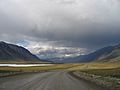
View of tundra in the summer from Dalton Highway, Northern Slope Borough, Alaska
-
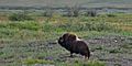
Muskox (Ovibos moschatus), Dalton Highway (Hwy 11) Northern Slope Borough, Alaska (10 August 2010)
-
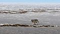
Wolf photographed from the Dalton Highway, Northern Slope Borough, Alaska (10 May 2016)
-

Aerial view of the highway with the Trans-Alaska Pipeline in the background (14 April 2015)
-
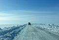
Highway about 10 miles south of Deadhourse, Northern Slope Borough, Alaska (5 April 2015)
-
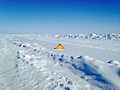
Highway sign in the snow, Northern Slope Borough, Alaska (17 April 2015)
-
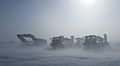
Winter conditions on the Dalton Highway (April 2016)

.jpg)
.jpg)


.jpg)
,_Dalton_Highway_(Hwy_11)_Northern_Slope_Borough,_Alaska_(10_August_2010).jpg)
.jpg)
.jpg)
_(cropped).jpg)
.jpg)
_(cropped).jpg)
See also
 In Spanish: Autopista Dalton para niños
