
Wiseman, Alaska facts for kids
Quick facts for kids
Wiseman, Alaska
|
|
|---|---|

The log-built post office at Wiseman, seen here in 1995, has been sinking into the ground for the past century, and is now a couple of feet below ground.
|
|

Location of Wiseman, Alaska
|
|
| Country | United States |
| State | Alaska |
| Census Area | Yukon-Koyukuk |
| Area | |
| • Total | 78.03 sq mi (202.11 km2) |
| • Land | 78.01 sq mi (202.05 km2) |
| • Water | 0.02 sq mi (0.05 km2) |
| Elevation | 1,181 ft (360 m) |
| Population
(2020)
|
|
| • Total | 5 |
| • Density | 0.06/sq mi (0.02/km2) |
| Time zone | UTC-9 (Alaska (AKST)) |
| • Summer (DST) | UTC-8 (AKDT) |
| ZIP code |
99726
|
| Area code | 907 |
| FIPS code | 02-85610 |
| GNIS feature ID | 1414284 |
Wiseman is a very small community in Alaska, United States. It is located in the Yukon-Koyukuk Census Area. In 2020, only 5 people lived there. However, in 2022, the number of full-time residents was 12.
Wiseman started as a gold mining town. It is located along the Middle Fork Koyukuk River in the Brooks Range mountains. Gold miners founded it around 1908. They moved there from another settlement called Slate Creek, which later became Coldfoot.
A famous American forester and activist, Robert Marshall, wrote a popular book about Wiseman. The book is called Arctic Village. He lived in Wiseman for 15 months around 1930. Marshall described Wiseman and the area around the Koyukuk River as "the happiest civilization of which I have knowledge." He also mentioned that the first flight to Wiseman by Noel Wien in 1925 was a very important event for the area.
Wiseman is about 3 miles (5 km) from the Dalton Highway. It was not connected to this main road until the early 1990s.
Contents
Where is Wiseman Located?
Wiseman is found at 67.433355 degrees North latitude and -150.094376 degrees West longitude.
The community covers an area of about 78.1 square miles (202.1 square kilometers). Most of this area is land. Only a tiny part, about 0.04 square miles (0.05 square kilometers), is water. Wiseman Creek flows right through the town.
What is the Climate Like in Wiseman?
Wiseman has a subarctic climate. This means it has short, mild summers. During summer, it often rains, and nights are cool. Winters are very long and extremely cold.
The area gets a lot of snow. On average, about 82 inches (208 cm) of snow falls each year. February usually has the most snow, with about 18.2 inches (46 cm).
| Climate data for Wiseman, Alaska, 1991–2020 normals, extremes 1918–present | |||||||||||||
|---|---|---|---|---|---|---|---|---|---|---|---|---|---|
| Month | Jan | Feb | Mar | Apr | May | Jun | Jul | Aug | Sep | Oct | Nov | Dec | Year |
| Record high °F (°C) | 35 (2) |
40 (4) |
49 (9) |
68 (20) |
81 (27) |
88 (31) |
89 (32) |
86 (30) |
72 (22) |
56 (13) |
38 (3) |
36 (2) |
89 (32) |
| Mean maximum °F (°C) | 21.4 (−5.9) |
29.0 (−1.7) |
34.3 (1.3) |
52.5 (11.4) |
72.3 (22.4) |
80.5 (26.9) |
81.7 (27.6) |
75.1 (23.9) |
61.6 (16.4) |
42.7 (5.9) |
26.4 (−3.1) |
24.2 (−4.3) |
83.0 (28.3) |
| Mean daily maximum °F (°C) | −0.5 (−18.1) |
5.8 (−14.6) |
18.6 (−7.4) |
37.6 (3.1) |
56.0 (13.3) |
70.0 (21.1) |
69.8 (21.0) |
62.0 (16.7) |
48.7 (9.3) |
27.6 (−2.4) |
6.9 (−13.9) |
3.4 (−15.9) |
33.8 (1.0) |
| Daily mean °F (°C) | −9.9 (−23.3) |
−4.8 (−20.4) |
4.0 (−15.6) |
24.1 (−4.4) |
42.7 (5.9) |
56.6 (13.7) |
57.5 (14.2) |
50.6 (10.3) |
38.6 (3.7) |
19.0 (−7.2) |
−1.6 (−18.7) |
−6.0 (−21.1) |
22.6 (−5.2) |
| Mean daily minimum °F (°C) | −19.3 (−28.5) |
−15.5 (−26.4) |
−10.6 (−23.7) |
10.6 (−11.9) |
29.3 (−1.5) |
43.2 (6.2) |
45.1 (7.3) |
39.3 (4.1) |
28.6 (−1.9) |
10.4 (−12.0) |
−10.2 (−23.4) |
−15.4 (−26.3) |
11.3 (−11.5) |
| Mean minimum °F (°C) | −49.8 (−45.4) |
−43.0 (−41.7) |
−34.2 (−36.8) |
−16.6 (−27.0) |
11.1 (−11.6) |
32.8 (0.4) |
34.4 (1.3) |
26.3 (−3.2) |
14.7 (−9.6) |
−10.7 (−23.7) |
−27.0 (−32.8) |
−41.3 (−40.7) |
−52.8 (−47.1) |
| Record low °F (°C) | −65 (−54) |
−65 (−54) |
−58 (−50) |
−39 (−39) |
−10 (−23) |
20 (−7) |
25 (−4) |
13 (−11) |
−2 (−19) |
−35 (−37) |
−50 (−46) |
−58 (−50) |
−65 (−54) |
| Average precipitation inches (mm) | 0.79 (20) |
0.95 (24) |
0.47 (12) |
0.58 (15) |
1.06 (27) |
1.83 (46) |
2.71 (69) |
2.74 (70) |
1.89 (48) |
1.12 (28) |
0.87 (22) |
0.93 (24) |
15.94 (405) |
| Average snowfall inches (cm) | 16.2 (41) |
18.2 (46) |
4.4 (11) |
5.6 (14) |
0.6 (1.5) |
0.0 (0.0) |
0.0 (0.0) |
0.0 (0.0) |
3.3 (8.4) |
9.2 (23) |
11.2 (28) |
13.3 (34) |
82.0 (208) |
| Average precipitation days (≥ 0.01 in) | 6.9 | 9.2 | 3.1 | 6.3 | 6.3 | 11.4 | 14.4 | 13.6 | 12.2 | 8.8 | 7.4 | 8.9 | 108.5 |
| Average snowy days (≥ 0.1 in) | 7.8 | 10.3 | 4.3 | 3.7 | 0.5 | 0.0 | 0.0 | 0.0 | 1.7 | 7.7 | 8.6 | 9.1 | 53.8 |
| Source: NOAA | |||||||||||||
Population Changes in Wiseman
| Historical population | |||
|---|---|---|---|
| Census | Pop. | %± | |
| 1930 | 58 | — | |
| 1940 | 53 | −8.6% | |
| 1990 | 33 | — | |
| 2000 | 21 | −36.4% | |
| 2010 | 14 | −33.3% | |
| 2020 | 5 | −64.3% | |
| U.S. Decennial Census | |||
Wiseman first appeared in the U.S. Census in 1930. Back then, 58 people lived there. The population has changed a lot over the years. By 2020, only 5 people were counted.
In 2000, Wiseman became a "census-designated place" (CDP). This means it's an area identified by the census bureau for statistics.

In 2000, there were 21 people living in Wiseman. They lived in 7 households, and 3 of these were families. Most of the people (81%) were White, and 19% were Native American.
The population was quite young in 2000. About 40% of the people were under 18 years old. The average age was 34 years. There were more males than females.
Education in Wiseman
In the past, the community had a school. It was part of the Yukon–Koyukuk School District.
Films About Wiseman
Several films have featured or been shot in Wiseman:
- Wise Men of Alaska (2000) was a film made by Zoltan Szalkai.
- Gates of the Arctic: Alaska's Brooks Range (2007) also showed the area.
- The TV show Life Below Zero features people living in Wiseman.
Images for kids
-
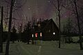
House in Wiseman, Alaska, with the Aurora Borealis in the sky.
See also
 In Spanish: Wiseman (Alaska) para niños
