
Livengood, Alaska facts for kids
Quick facts for kids
Livengood, Alaska
|
|
|---|---|

Livengood cabin
|
|

Location of Livengood, Alaska
|
|
| Country | United States |
| State | Alaska |
| Census Area | Yukon-Koyukuk |
| Area | |
| • Total | 265.64 sq mi (688.01 km2) |
| • Land | 265.16 sq mi (686.76 km2) |
| • Water | 0.48 sq mi (1.25 km2) |
| Elevation | 696 ft (212 m) |
| Population
(2020)
|
|
| • Total | 16 |
| • Density | 0.06/sq mi (0.02/km2) |
| Time zone | UTC-9 (Alaska (AKST)) |
| • Summer (DST) | UTC-8 (AKDT) |
| ZIP code |
99712
|
| Area code | 907 |
| FIPS code | 02-44580 |
| GNIS feature ID | 1405579 |
Livengood is a very small community in Alaska, United States. It is so small that it is called a "census-designated place" (CDP). This means it's a special area defined by the government for counting people, but it doesn't have its own city government. In 2020, only 16 people lived in Livengood.
Contents
History of Livengood
Livengood was founded because of gold! In 1914, two men named N.R. Hudson and Jay Livengood found gold in a nearby creek. Many people rushed to the area, hoping to find their own gold.
A small village quickly grew around the gold claims. It became a busy mining camp during the winter of 1914-1915. A post office was opened in 1915 to help the growing community. It stayed open until 1957.
Later, a large construction camp was set up near Livengood. This was during the building of the Trans-Alaska Pipeline System. This huge pipeline carries oil across Alaska.
Geography of Livengood
Livengood is located in a part of Alaska called the Yukon-Koyukuk Census Area. You can find it at these coordinates: 65°29′24″N 148°32′48″W / 65.49000°N 148.54667°W.
The area of Livengood is quite large, even though few people live there. It covers about 267.8 square miles (693.6 square kilometers). Most of this area is land, with a small amount of water.
Climate in Livengood
Livengood has a very cold climate, especially in winter. It's known as a dry-winter continental subarctic climate. This means winters are long, very cold, and snowy, while summers are short and cool.
| Climate data for Livengood | |||||||||||||
|---|---|---|---|---|---|---|---|---|---|---|---|---|---|
| Month | Jan | Feb | Mar | Apr | May | Jun | Jul | Aug | Sep | Oct | Nov | Dec | Year |
| Record high °F (°C) | 38 (3) |
36 (2) |
50 (10) |
91 (33) |
79 (26) |
90 (32) |
88 (31) |
87 (31) |
78 (26) |
70 (21) |
44 (7) |
39 (4) |
91 (33) |
| Mean daily maximum °F (°C) | −8 (−22) |
−0.3 (−17.9) |
14.7 (−9.6) |
35.2 (1.8) |
51.4 (10.8) |
67.4 (19.7) |
68.8 (20.4) |
61.6 (16.4) |
48.6 (9.2) |
26.9 (−2.8) |
6.2 (−14.3) |
0.3 (−17.6) |
31.1 (−0.5) |
| Mean daily minimum °F (°C) | −19.4 (−28.6) |
−13 (−25) |
−5.9 (−21.1) |
10.9 (−11.7) |
30.1 (−1.1) |
42.9 (6.1) |
45.5 (7.5) |
42.7 (5.9) |
29.5 (−1.4) |
15.3 (−9.3) |
−5.6 (−20.9) |
−12.6 (−24.8) |
13.4 (−10.3) |
| Record low °F (°C) | −55 (−48) |
−50 (−46) |
−41 (−41) |
−20 (−29) |
−5 (−21) |
28 (−2) |
28 (−2) |
25 (−4) |
10 (−12) |
−16 (−27) |
−47 (−44) |
−50 (−46) |
−55 (−48) |
| Average precipitation inches (mm) | 0.18 (4.6) |
0.22 (5.6) |
0.33 (8.4) |
0.27 (6.9) |
0.81 (21) |
1.24 (31) |
2.38 (60) |
2.38 (60) |
1.4 (36) |
0.6 (15) |
0.32 (8.1) |
0.51 (13) |
10.63 (270) |
| Average snowfall inches (cm) | 6.7 (17) |
7.7 (20) |
5.4 (14) |
4.1 (10) |
0.5 (1.3) |
0 (0) |
0 (0) |
0 (0) |
0.3 (0.76) |
8.1 (21) |
8.1 (21) |
11.2 (28) |
52.3 (133) |
| Average precipitation days | 3 | 3 | 3 | 2 | 4 | 8 | 10 | 11 | 7 | 5 | 4 | 4 | 64 |
Population Changes
| Historical population | |||
|---|---|---|---|
| Census | Pop. | %± | |
| 1920 | 131 | — | |
| 1930 | 22 | −83.2% | |
| 1940 | 153 | 595.5% | |
| 1950 | 40 | −73.9% | |
| 2000 | 29 | — | |
| 2010 | 13 | −55.2% | |
| 2020 | 16 | 23.1% | |
| U.S. Decennial Census | |||
Livengood first appeared in the U.S. Census in 1920. Back then, 131 people lived there. The population has changed a lot over the years. In 2010, only 13 people lived there, but by 2020, it grew slightly to 16 people.
Images for kids
-
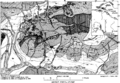
A Geologic map of the Livengood District, showing areas where placer mining (gold mining from riverbeds) took place.

See also
 In Spanish: Livengood (Alaska) para niños
