
Galbraith Lake facts for kids
Quick facts for kids Galbraith Lake |
|
|---|---|
 |
|

Galbraith Lake
Location in Alaska

Galbraith Lake
Location in North America
|
|
| Location | North Slope Borough, Alaska |
| Coordinates | 68°28′N 149°25′W / 68.467°N 149.417°W |
| Basin countries | United States |
| Max. length | 3.6 miles (5.8 km) |
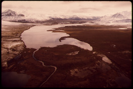
Galbraith Lake is a beautiful lake located in the North Slope Borough of Alaska, United States. This area is mostly wild, with only a few people living there at certain times of the year.
The lake sits on the west side of the Dalton Highway, a famous road in Alaska. It's about 3.6 miles (5.8 km) long. This lake was formed by huge sheets of ice called glaciers long ago. You can find different types of fish here, like lake trout, burbot, and grayling. Some people have also reported seeing Arctic char. There's even a campground nearby where visitors can stay.
Galbraith Lake was named in 1951 to honor Bart Galbraith. He was a brave bush pilot who flew small planes in remote areas. Sadly, he died in a plane crash in 1950 while flying between two Alaskan towns, Barter Island and Barrow.
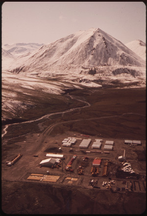
Near the lake, you'll find the Galbraith Lake Airport. There's also Pump Station 4, which is part of the Trans-Alaska Pipeline System. This pipeline carries oil across Alaska.
During the 1970s, a work camp was set up at Galbraith Lake when the pipeline was being built. In 1975, there was a small oil spill near the camp. Some oil got into the lake, and a slick appeared on the surface. Workers quickly cleaned it up. The pipeline project also helped scientists explore the area. They found many interesting things about the land and its history.
Visiting Galbraith Lake: Campground Fun
The Galbraith Lake Bureau of Land Management Campground is a great spot for camping. It's located about 359 miles (578 km) north of Fairbanks and 140 miles (225 km) south of Deadhorse. You can find it around the 275-mile mark of the Dalton Highway. It's a perfect place to enjoy the Alaskan wilderness.
Understanding the Climate at Galbraith Lake
Galbraith Lake has a very cold climate. It's known as a subarctic climate, which is almost like a tundra climate. This means it's cold for most of the year. It can even snow in June, July, and August!
During the time the Alaska Pipeline was being built, there was a weather station at Galbraith Lake. This station recorded temperatures and how much snow and rain fell. Because it only operated for about ten years, the weather records are not complete. December is usually the coldest month. The highest and lowest temperatures recorded here are not as extreme as in other nearby places. Also, some months have very little rainfall data.
| Climate data for Galbraith Lake | |||||||||||||
|---|---|---|---|---|---|---|---|---|---|---|---|---|---|
| Month | Jan | Feb | Mar | Apr | May | Jun | Jul | Aug | Sep | Oct | Nov | Dec | Year |
| Mean daily maximum °F (°C) | 2 (−17) |
−4 (−20) |
3 (−16) |
19 (−7) |
42 (6) |
56 (13) |
61 (16) |
59 (15) |
40 (4) |
16 (−9) |
10 (−12) |
−5 (−21) |
25 (−4) |
| Mean daily minimum °F (°C) | −18 (−28) |
−25 (−32) |
−21 (−29) |
−6 (−21) |
19 (−7) |
36 (2) |
40 (4) |
37 (3) |
20 (−7) |
−3 (−19) |
−11 (−24) |
−24 (−31) |
4 (−16) |
| Average precipitation inches (mm) | 0.68 (17) |
0.26 (6.6) |
0.39 (9.9) |
0.12 (3.0) |
0.36 (9.1) |
1.42 (36) |
0.93 (24) |
1.60 (41) |
0.70 (18) |
1.00 (25) |
0.50 (13) |
0.51 (13) |
8.46 (215) |
| Average snowfall inches (cm) | 8.5 (22) |
2.9 (7.4) |
6.8 (17) |
1.4 (3.6) |
0 (0) |
0.7 (1.8) |
0.5 (1.3) |
trace | 4.6 (12) |
9.2 (23) |
6.6 (17) |
5.0 (13) |
46.1 (117) |
Past Names for Galbraith Lake
Before it was called Galbraith Lake, this body of water had other names. It was sometimes known as "Natravak Lake" or "Sagavanirktok Lake." "Natravak" is an Eskimo word that means "big lake." This name is quite common for large lakes in northern Alaska.
