Barter Island facts for kids
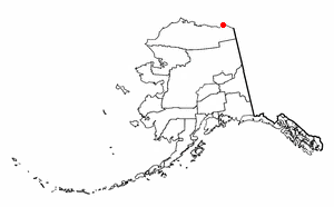
Barter Island is an island located on the Arctic coast of Alaska, a U.S. state. It lies east of Arey Island in the Beaufort Sea. The island is about four miles (6 km) long and two miles (3 km) wide at its widest point.

For many years, until the late 1800s, Barter Island was a very important trading spot. It was a central place for the Inupiat from Alaska and the Inuit from Canada to trade goods. This is why it's called "Barter Island"—because people came here to barter, or exchange, things.
Before 1900, there was a large whaling village on Barter Island. Stories say that the Alaska Inupiat people caused the Canadian Inupiat villagers to leave the island around 1900.
Around 1919, a trader named Tom Gordon and his wife, Mary Agiaq Gordon, moved to Barter Island. They came from Barrow with their family, friends, and relatives. Mary's younger brother, Andrew Akootchook, helped them choose the spot for their trading post. It was a good location because it had a safe harbor and was easy to reach for hunting on land and at sea. Tom Gordon and the new settlers built a trading post there. A few families then settled near Gordon's trading post.
Contents
Building the DEW Line
Starting in March 1953, a special runway and a radar station were built on Barter Island. This project was part of the Distant Early Warning Line, or DEW Line. The DEW Line was a system of radar stations built across the Arctic. Its purpose was to detect if any enemy aircraft were flying over the North Pole towards North America.
The company Western Electric built the station. The U.S. Navy helped by bringing supplies by sea. The U.S. Air Force used large Douglas C-124 Globemaster II planes to carry heavy equipment. Barter Island was chosen as the first test site for the DEW Line. This meant they built a prototype station here to make sure the system would work.
The station was finished in November 1953. The Air Force then tested the system in 1954. After these tests, Western Electric was hired in September 1954 to build the rest of the DEW Line. This huge network of stations stretched across Alaska, Canada, Greenland, and Iceland.
Modern Life on Barter Island
After the DEW Line runway was built, several families decided to settle nearby. In 1971, the area around the runway officially became a city. It was named Kaktovik.
In 1970, three special rockets were launched from Barter Island. These were called Nike-Tomahawk sounding rockets. They were used for high-altitude research, meaning they studied the upper parts of Earth's atmosphere.
Barter Island's Climate
Barter Island has a tundra climate. This type of climate means it has very long, cold winters. The summers are short, but they can have warm days.
| Climate data for Barter Island WSO airport (1961–1990 normals, extremes 1947–present) | |||||||||||||
|---|---|---|---|---|---|---|---|---|---|---|---|---|---|
| Month | Jan | Feb | Mar | Apr | May | Jun | Jul | Aug | Sep | Oct | Nov | Dec | Year |
| Record high °F (°C) | 39 (4) |
37 (3) |
36 (2) |
43 (6) |
52 (11) |
68 (20) |
78 (26) |
72 (22) |
66 (19) |
49 (9) |
41 (5) |
37 (3) |
78 (26) |
| Mean maximum °F (°C) | 19.7 (−6.8) |
13.2 (−10.4) |
14.0 (−10.0) |
27.3 (−2.6) |
40.6 (4.8) |
54.6 (12.6) |
63.6 (17.6) |
60.0 (15.6) |
50.0 (10.0) |
34.1 (1.2) |
23.9 (−4.5) |
22.4 (−5.3) |
65.5 (18.6) |
| Mean daily maximum °F (°C) | −7.4 (−21.9) |
−12.9 (−24.9) |
−8.7 (−22.6) |
6.3 (−14.3) |
25.9 (−3.4) |
38.5 (3.6) |
44.8 (7.1) |
43.3 (6.3) |
35.0 (1.7) |
19.5 (−6.9) |
4.1 (−15.5) |
−4.7 (−20.4) |
15.4 (−9.2) |
| Daily mean °F (°C) | −12.5 (−24.7) |
−19.7 (−28.7) |
−16.1 (−26.7) |
−2.0 (−18.9) |
20.9 (−6.2) |
34.5 (1.4) |
40.0 (4.4) |
38.8 (3.8) |
31.5 (−0.3) |
14.3 (−9.8) |
−1.6 (−18.7) |
−11.6 (−24.2) |
9.7 (−12.4) |
| Mean daily minimum °F (°C) | −19.8 (−28.8) |
−25.3 (−31.8) |
−22.4 (−30.2) |
−9.2 (−22.9) |
14.9 (−9.5) |
30.0 (−1.1) |
34.4 (1.3) |
33.8 (1.0) |
27.2 (−2.7) |
9.5 (−12.5) |
−7.2 (−21.8) |
−17.5 (−27.5) |
4.1 (−15.5) |
| Mean minimum °F (°C) | −39.3 (−39.6) |
−45.3 (−42.9) |
−40.6 (−40.3) |
−30.7 (−34.8) |
−1.6 (−18.7) |
23.6 (−4.7) |
28.8 (−1.8) |
27.3 (−2.6) |
16.3 (−8.7) |
−11.1 (−23.9) |
−27.9 (−33.3) |
−38.3 (−39.1) |
−48.5 (−44.7) |
| Record low °F (°C) | −54 (−48) |
−59 (−51) |
−51 (−46) |
−44 (−42) |
−16 (−27) |
9 (−13) |
24 (−4) |
20 (−7) |
4 (−16) |
−26 (−32) |
−51 (−46) |
−51 (−46) |
−59 (−51) |
| Average precipitation inches (mm) | 0.37 (9.4) |
0.20 (5.1) |
0.23 (5.8) |
0.19 (4.8) |
0.28 (7.1) |
0.43 (11) |
0.95 (24) |
1.03 (26) |
0.69 (18) |
0.62 (16) |
0.38 (9.7) |
0.26 (6.6) |
5.62 (143) |
| Average snowfall inches (cm) | 4.2 (11) |
2.2 (5.6) |
2.7 (6.9) |
2.4 (6.1) |
2.8 (7.1) |
1.6 (4.1) |
0.5 (1.3) |
1.6 (4.1) |
4.6 (12) |
8.8 (22) |
5.1 (13) |
3.5 (8.9) |
40.0 (102) |
| Average precipitation days (≥ 0.01 inch) | 4.6 | 4.3 | 4.4 | 4.9 | 5.4 | 5.3 | 8.0 | 11.8 | 9.7 | 11.8 | 7.1 | 5.3 | 82.6 |
| Average snowy days (≥ 0.1 inch) | 4.7 | 4.7 | 4.8 | 5.5 | 5.6 | 2.2 | 0.6 | 2.3 | 6.0 | 11.8 | 7.2 | 5.8 | 61.2 |
| Source 1: WRCC | |||||||||||||
| Source 2: XMACIS (snowfall) | |||||||||||||
People of Barter Island
To learn more about the people living on Barter Island today, you can look up information about Kaktovik.
See also
 In Spanish: Isla Barter para niños
 | Shirley Ann Jackson |
 | Garett Morgan |
 | J. Ernest Wilkins Jr. |
 | Elijah McCoy |


