Kaktovik, Alaska facts for kids
Quick facts for kids
Kaktovik, Alaska
Qaaktuġvik
|
|
|---|---|

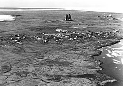
Aerial view of Kaktovik and Barter Island LRRS.
|
|

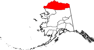
Location in North Slope Borough, Alaska
|
|
| Country | United States |
| State | Alaska |
| Borough | North Slope |
| Incorporated | March 26, 1971 |
| Area | |
| • Total | 1.05 sq mi (2.71 km2) |
| • Land | 0.77 sq mi (2.01 km2) |
| • Water | 0.27 sq mi (0.70 km2) |
| Elevation | 36 ft (11 m) |
| Population
(2020)
|
|
| • Total | 283 |
| • Density | 365.63/sq mi (141.12/km2) |
| Time zone | UTC-9 (Alaska (AKST)) |
| • Summer (DST) | UTC-8 (AKDT) |
| ZIP code |
99747
|
| Area code | 907 |
| FIPS code | 02-36990 |
| GNIS feature ID | 1404349, 2419404 |
Kaktovik (which sounds like "kak-TOH-vik") is a small city in North Slope Borough, Alaska, United States. Its name in the local Inupiat language, Qaaktuġvik, means "Seining Place." This refers to a type of fishing using a net. In 2020, about 283 people lived there.
Contents
History of Kaktovik
Early Trading Post
For many years, Barter Island was a very important trading spot. It was a place where the Inupiat from Alaska and the Inuit from Canada would meet. They would trade goods and supplies with each other.
Growth of the Village
Kaktovik itself was known as a great fishing area. It had a large pond of fresh water on high ground. Before the 1950s, no one lived there all the time. But then, a runway and a military station called the Distant Early Warning Line were built. This brought people from other parts of Barter Island and northern Alaska to settle in Kaktovik. The area officially became the City of Kaktovik in 1971.
Inupiat Traditions and Wildlife
Because Kaktovik is so far away from other places, its people have kept their traditional Inupiat Eskimo ways of life. They rely a lot on hunting caribou and whale for food and resources. This way of life is called subsistence.
In recent years, Kaktovik has become a popular place for tourists. People come to see polar bears. This is partly because the local Inupiat people are allowed to hunt a few bowhead whales each year. After they remove the meat and blubber (a process called flensing), they leave the whale bones on the beach. This provides food for the polar bears, making them easier to spot.
Geography and Location
Kaktovik is located on the northern coast of Barter Island. It sits between the Okpilak River and the Jago River, right on the Beaufort Sea. The city is also inside the huge Arctic National Wildlife Refuge, which is about 19.6 million acres (79,300 square kilometers) in size.
According to the United States Census Bureau, Kaktovik covers about 1.0 square mile (2.7 square kilometers). Most of this area, about 0.8 square miles (2.0 square kilometers), is land. The rest, about 0.2 square miles (0.7 square kilometers), is water.
Transportation
The main way to get to Kaktovik is by air. The Barter Island LRRS Airport is located very close to the city.
Climate
Kaktovik is located very far north, at 70 degrees North latitude. This means it has a Tundra climate.
Seasons in Kaktovik
- Winters: Winters are very long and extremely cold. Because Kaktovik is so far north, the sun does not rise above the horizon for weeks in the middle of winter. This means there is only a little bit of twilight during the day.
- Summers: Summers are cool, which is typical for the North Slope of Alaska. During a few weeks in spring and summer, Kaktovik experiences the midnight sun. This means the sun stays visible for 24 hours a day.
Precipitation and Snowfall
Kaktovik gets very little rain, similar to a desert. It only gets about 4 inches (10 cm) of precipitation each year. Most of this falls between July and September. Snow is more common in the colder months, but it can even snow in the summer because it's still quite cold.
| Climate data for Kaktovik, Alaska 1992-2021 | |||||||||||||
|---|---|---|---|---|---|---|---|---|---|---|---|---|---|
| Month | Jan | Feb | Mar | Apr | May | Jun | Jul | Aug | Sep | Oct | Nov | Dec | Year |
| Record high °F (°C) | 39 (4) |
37 (3) |
36 (2) |
43 (6) |
52 (11) |
68 (20) |
78 (26) |
74 (23) |
66 (19) |
46 (8) |
35 (2) |
24 (−4) |
78 (26) |
| Mean maximum °F (°C) | 21 (−6) |
17 (−8) |
20 (−7) |
33 (1) |
45 (7) |
57 (14) |
68 (20) |
63 (17) |
52 (11) |
40 (4) |
28 (−2) |
22 (−6) |
71 (22) |
| Mean daily maximum °F (°C) | −5.0 (−20.6) |
−5.0 (−20.6) |
−1 (−18) |
14 (−10) |
31 (−1) |
43 (6) |
52 (11) |
48 (9) |
38 (3) |
26 (−3) |
11 (−12) |
1 (−17) |
21.1 (−6.1) |
| Daily mean °F (°C) | −11 (−24) |
−11.5 (−24.2) |
−9 (−23) |
6.5 (−14.2) |
26 (−3) |
38 (3) |
46 (8) |
43 (6) |
34.5 (1.4) |
21 (−6) |
5.5 (−14.7) |
−6.5 (−21.4) |
15.2 (−9.3) |
| Mean daily minimum °F (°C) | −17 (−27) |
−18 (−28) |
−17 (−27) |
−1 (−18) |
21 (−6) |
33 (1) |
40 (4) |
38 (3) |
31 (−1) |
16 (−9) |
−1 (−18) |
−12 (−24) |
9 (−12) |
| Mean minimum °F (°C) | −38 (−39) |
−39 (−39) |
−36 (−38) |
−20 (−29) |
5 (−15) |
25 (−4) |
31 (−1) |
29 (−2) |
19 (−7) |
−6 (−21) |
−20 (−29) |
−33 (−36) |
−42.8 (−41.6) |
| Record low °F (°C) | −54 (−48) |
−59 (−51) |
−51 (−46) |
−44 (−42) |
−16 (−27) |
13 (−11) |
24 (−4) |
20 (−7) |
4 (−16) |
−26 (−32) |
−51 (−46) |
−51 (−46) |
−59 (−51) |
| Average precipitation inches (mm) | 0.13 (3.3) |
0.20 (5.1) |
0.17 (4.3) |
0.15 (3.8) |
0.28 (7.1) |
0.47 (12) |
0.53 (13) |
0.82 (21) |
0.51 (13) |
0.27 (6.9) |
0.14 (3.6) |
0.13 (3.3) |
3.8 (96.4) |
| Average snowfall inches (cm) | 4.7 (12) |
2.6 (6.6) |
2.5 (6.4) |
2.3 (5.8) |
3.0 (7.6) |
1.6 (4.1) |
0.5 (1.3) |
1.5 (3.8) |
5.6 (14) |
9.3 (24) |
5.0 (13) |
3.2 (8.1) |
41.8 (106.7) |
| Source 1: https://wrcc.dri.edu/cgi-bin/cliMAIN.pl?ak0558 | |||||||||||||
| Source 2: https://www.timeanddate.com/weather/usa/kaktovik/climate | |||||||||||||
Population of Kaktovik
| Historical population | |||
|---|---|---|---|
| Census | Pop. | %± | |
| 1950 | 46 | — | |
| 1960 | 120 | 160.9% | |
| 1970 | 123 | 2.5% | |
| 1980 | 165 | 34.1% | |
| 1990 | 224 | 35.8% | |
| 2000 | 293 | 30.8% | |
| 2010 | 239 | −18.4% | |
| 2020 | 283 | 18.4% | |
| U.S. Decennial Census | |||
Kaktovik first appeared on the U.S. Census in 1950. At that time, it was a small village with only 46 people. The population grew over the years. In 1960, it was listed as "Barter Island" on the census. In 1970, the name Kaktovik was used again, and the city was officially formed in 1971.
In 2010, there were 239 people living in Kaktovik. Most of the people, about 88.7%, were Native American. About 10.0% were White, and a small number were from two or more racial backgrounds.
Education
The North Slope Borough School District runs the Harold Kaveolook School in Kaktovik. Sadly, the school had a big fire on February 6, 2020, which caused a lot of damage.
See also
 In Spanish: Kaktovik para niños
 | Bessie Coleman |
 | Spann Watson |
 | Jill E. Brown |
 | Sherman W. White |


