Prospect Creek, Alaska facts for kids
Quick facts for kids
Prospect Creek, Alaska
|
|
|---|---|

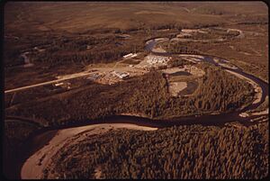
Prospect Creek as viewed from a nearby hillside
|
|
| Country | United States |
| State | Alaska |
| Census Area | Yukon-Koyukuk |
| Area | |
| • Total | 48 sq mi (125 km2) |
| Elevation | 1,014 ft (309 m) |
| Population
(2000)
|
|
| • Total | Uninhabited |
| Time zone | UTC-9 (Alaska (AKST)) |
| • Summer (DST) | UTC-8 (AKDT) |
| Area code(s) | 907 |
Prospect Creek is a tiny place in Alaska, about 180 miles (290 km) north of Fairbanks. It's also about 25 miles (40 km) southeast of Bettles, Alaska. Years ago, it was a busy spot for mining. It also served as a camp for workers building the huge Trans-Alaska Pipeline System (TAPS).
Today, Prospect Creek is home to Pump Station 5 (Jim River Station) of the TAPS. It's also famous for holding the United States record for the lowest temperature ever recorded. On January 23, 1971, the temperature dropped to an incredible −79.8 °F (−62.1 °C)! Even with such extreme cold, wildlife like black and brown bears and bald eagles can be found here. Prospect Creek sits 643 feet (196 m) above sea level. Nearby Moore Creek is known for its gold and quartz mining. Both are in Alaska’s Innoko Mining District, which is famous for finding large quartz crystals.
Contents
History of Prospect Creek
A camp was built near Prospect Creek in 1974. It housed some of the 27,000 people working on the Trans-Alaska Pipeline System (TAPS). This camp also supported Pump Station 5. The camp had basic housing and washrooms.
After the TAPS was finished in 1977, the camp was taken down and left empty. Not much was left behind, just an airstrip and a large gravel pad.
Wolf Encounter in 1974
During the pipeline's construction in 1974, a wolf attacked someone. The person only had minor bruises and no broken skin. The wolf was later killed and tested. It did not have rabies.
Later Uses of the Camp
The camp was used again in 1992. It became the first campsite for workers, engineers, and their families. They were helping to replace bridges along the nearby Dalton Highway. Today, campers and other short-term visitors sometimes use the area.
Geography and Location
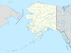
Prospect Creek is located about 34 miles (55 km) north of the center of Alaska. Its exact coordinates are 66°48′48″N 150°38′38″W / 66.81333°N 150.64389°W. This spot is just above the Arctic Circle. You can find it right off the James Dalton Highway, at the 135th mile (217th kilometer) marker.
Coldfoot is the closest city, about 31 miles (50 km) northeast of Prospect Creek. The old camp was near the start of a winter road that goes to Bettles. This road begins just south of TAPS Pump Station 5 on the Dalton Highway.
Rivers and Surroundings
According to the Bureau of Land Management, Prospect Creek joins the Jim River within 3 miles (4.8 km) of the main road. The Jim River then flows south into the South Fork of the Koyukuk River.
The Prospect Creek area itself is quite flat. However, its surroundings are hilly and green. This is typical of a boreal forest, which is a type of cold-weather forest.
Natural Resources
Because of its unique mix of extreme cold and unusual landforms, Prospect Creek has special minerals. These include tungsten and bismuth. Bismuth has been found in quartz veins in the area. Even with these valuable natural resources, no company has mined them yet. This is because the location is very remote and hard to reach.
Getting There
Prospect Creek has a small airstrip called Prospect Creek Airport (PPC/PAPR). Driving to Prospect Creek from Fairbanks is a 220-mile trip north. You would take the Steese and Elliot Highways. The drive usually takes about 4 to 5 hours in good weather. However, it can be very dangerous in winter. Some companies offer group tours to this area in the summer.
Nearby Protected Areas
Prospect Creek is close to two National Wildlife Reserves: Kanuti and Yukon Flats. It is also southeast of the Gates of the Arctic National Park. These areas protect the natural environment and wildlife.
Climate and Temperatures
Prospect Creek has a subarctic climate. This means it has very long, cold winters and short, cool summers. It has experienced some of the coldest winters in U.S. history. No one lives in this area permanently anymore. The camp has been empty since the early 1990s.
Prospect Creek holds the record for the coldest temperature in the United States. On January 23, 1971, it was −79.8 °F (−62.1 °C). The average temperature there is about 20.4 °F (−6.4 °C). The coldest temperature ever recorded in North America was −93.3 °F (−69.6 °C) in Greenland on December 22, 1991.
Temperature Records
Here are some of the temperature records for Prospect Creek:
- Highest Temperature: 87 °F (31 °C) on August 1, 1977
- Warmest Minimum: 61 °F (16 °C) on July 14, 1975
- Coldest Maximum: −64 °F (−53 °C) on January 23, 1971
- Lowest Temperature: −80 °F (−62 °C) on January 23, 1971
Precipitation and Snowfall
- Highest Daily Precipitation: 2.06 inches (52 mm) on July 24, 1977
- Wettest Month: 5.25 inches (133 mm) in June 1974
- Wettest Year: 14.74 inches (374 mm) in 1976
- Driest Year: 9.93 inches (252 mm) in 1979
- Highest Daily Snowfall: 10.0 inches (25 cm) on November 10, 1978
- Snowiest Month: 45.4 inches (115 cm) in November 1978
- Snowiest Year: 162.6 inches (413 cm) in 1978
- Earliest Snowfall: September 4, 1976 (just a trace)
- Latest Snowfall: June 3, 1974 (just a trace)
- Deepest Snowpack: 60 inches (150 cm) on February 5–6, 1971, and again on February 10, 1971
A weather station was active in Prospect Creek from 1970 to 1980 during the Alaska Pipeline construction. After a long break, temperature readings started again in 2015. Some snow and rain measurements were also taken around 2001.
| Climate data for Prospect Creek Camp, Alaska (1970–2001) | |||||||||||||
|---|---|---|---|---|---|---|---|---|---|---|---|---|---|
| Month | Jan | Feb | Mar | Apr | May | Jun | Jul | Aug | Sep | Oct | Nov | Dec | Year |
| Record high °F (°C) | 35 (2) |
39 (4) |
37 (3) |
56 (13) |
76 (24) |
87 (31) |
87 (31) |
87 (31) |
73 (23) |
51 (11) |
46 (8) |
35 (2) |
87 (31) |
| Mean daily maximum °F (°C) | −6.8 (−21.6) |
1.1 (−17.2) |
15.5 (−9.2) |
33.5 (0.8) |
55.0 (12.8) |
64.4 (18.0) |
69.7 (20.9) |
65.1 (18.4) |
50.2 (10.1) |
25.6 (−3.6) |
7.5 (−13.6) |
−3.9 (−19.9) |
31.4 (−0.3) |
| Daily mean °F (°C) | −14.9 (−26.1) |
−11.2 (−24.0) |
3.1 (−16.1) |
20.0 (−6.7) |
42.9 (6.1) |
53.1 (11.7) |
58.0 (14.4) |
52.6 (11.4) |
39.3 (4.1) |
16.4 (−8.7) |
−1.2 (−18.4) |
−12.5 (−24.7) |
20.5 (−6.4) |
| Mean daily minimum °F (°C) | −22.9 (−30.5) |
−23.5 (−30.8) |
−10.7 (−23.7) |
6.4 (−14.2) |
30.8 (−0.7) |
42.0 (5.6) |
46.0 (7.8) |
40.1 (4.5) |
28.5 (−1.9) |
7.4 (−13.7) |
−10.0 (−23.3) |
−21.2 (−29.6) |
9.4 (−12.6) |
| Record low °F (°C) | −80 (−62) |
−64 (−53) |
−62 (−52) |
−43 (−42) |
7 (−14) |
20 (−7) |
31 (−1) |
17 (−8) |
4 (−16) |
−35 (−37) |
−62 (−52) |
−68 (−56) |
−80 (−62) |
| Average precipitation inches (mm) | 0.38 (9.7) |
0.48 (12) |
0.37 (9.4) |
0.20 (5.1) |
0.69 (18) |
2.34 (59) |
1.76 (45) |
1.98 (50) |
2.34 (59) |
1.14 (29) |
0.94 (24) |
0.57 (14) |
13.20 (335) |
| Average snowfall inches (cm) | 8.7 (22) |
8.0 (20) |
8.7 (22) |
4.7 (12) |
0.1 (0.25) |
0.0 (0.0) |
0.0 (0.0) |
0.0 (0.0) |
2.1 (5.3) |
15.0 (38) |
15.7 (40) |
14.1 (36) |
77.3 (196) |
| Source: https://wrcc.dri.edu/cgi-bin/cliMAIN.pl?ak7778 (WRCC) | |||||||||||||
 | Kyle Baker |
 | Joseph Yoakum |
 | Laura Wheeler Waring |
 | Henry Ossawa Tanner |


