
Bettles, Alaska facts for kids
Quick facts for kids
Bettles
Kk’odlel T’odegheelenh Denh
|
|
|---|---|

Aerial view of Bettles (right) and its neighbor Evansville (left)
|
|

Location in Alaska
|
|
| Country | United States |
| State | Alaska |
| Census Area | Yukon-Koyukuk |
| Incorporated | December 20, 1985 |
| Area | |
| • Total | 1.59 sq mi (4.12 km2) |
| • Land | 1.56 sq mi (4.05 km2) |
| • Water | 0.03 sq mi (0.07 km2) 0% |
| Elevation | 630 ft (200 m) |
| Population
(2020)
|
|
| • Total | 23 |
| • Density | 14.70/sq mi (5.67/km2) |
| Time zone | UTC−9 (Alaska (AKST)) |
| • Summer (DST) | UTC−8 (AKDT) |
| ZIP code |
99726
|
| Area code | 907 |
| FIPS code | 02-06630 |
| GNIS feature ID | 1926949 |
Bettles is a small city in Alaska, United States. Its name in the local Koyukon is Kk’odlel T’odegheelenh Denh, and in Iñupiaq it is Atchiiniq. Bettles is located in the Yukon-Koyukuk Census Area, close to the amazing Gates of the Arctic National Park and Preserve.
In 2020, only 23 people lived in Bettles. This was an increase from 12 people in 2010. It is one of the smallest cities in Alaska.
Contents
History of Bettles
The first village of Bettles started in the late 1890s. This was during the Klondike Gold Rush, when many people went to Alaska looking for gold. A man named Gordon C. Bettles, who was a newspaper writer, prospector, and trader, set up a trading post here in 1898. The village was named after him.
A post office opened in 1901. Later, people started moving about 5 miles (8 km) east to a place called Evansville. This move happened because an airstrip was built there during World War II. This airstrip is still used today for flights.
The old village was mostly left empty. A new city, called "New Bettles," was created from part of Evansville and officially became a city in 1985. The Hickel Highway was once used to bring supplies for oil exploration. Now, the Dalton Highway is a main route for trucks going to the oil fields.
-
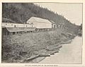
The Bettles Trading Post on the Koyukuk River at Old Bettles, Alaska.
-
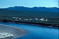
Bettles and the Koyukuk River at (New) Bettles, Alaska, in 2003.
-
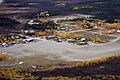
An aerial view of the Bettles community, (New) Bettles, Alaska, around 2013.


Population Changes
The population of Bettles has changed over the years. There were two main settlements: the original "Old Bettles" and the newer "New Bettles."
Old Bettles Population (1930–1960)
The first village of Bettles was located on the west side of the Koyukuk River. It appeared on the U.S. Census starting in 1930.
| Historical population | |||
|---|---|---|---|
| Census | Pop. | %± | |
| 1930 | 23 | — | |
| 1940 | 10 | −56.5% | |
| 1950 | 47 | 370.0% | |
| 1960 | 77 | 63.8% | |
| U.S. Decennial Census | |||
After the airstrip was built in Evansville, people began moving away from Old Bettles. The post office there closed in 1956. The last residents left the old village in 1997, but some buildings are still there today.
New Bettles Population (1990–present)
The current city of Bettles is about 5 miles (8 km) east of the old settlement. It is located near the Bettles Airstrip. This area was first known as Evansville.
| Historical population | |||
|---|---|---|---|
| Census | Pop. | %± | |
| 1990 | 36 | — | |
| 2000 | 43 | 19.4% | |
| 2010 | 12 | −72.1% | |
| 2020 | 23 | 91.7% | |
| U.S. Decennial Census | |||
In 1985, a part of Evansville became the city of Bettles. Since then, it has been listed on the U.S. Census again. In 2000, there were 43 people living in Bettles. The population dropped to 12 in 2010, but then rose to 23 by 2020.
Geography and Location
Bettles is located on the southeast bank of the Koyukuk River. It is about 35 miles (56 km) north of the Arctic Circle. This means it's very far north! The city is also just south of the Brooks Range, a large mountain range in Alaska.
The city has a gravel airstrip that is 5,190 feet (1,582 m) long. This airstrip was built by the military and helps people travel to and from Bettles. According to the United States Census Bureau, Bettles covers about 1.6 square miles (4.1 square kilometers) of land.
Climate in Bettles
Bettles has a subarctic climate, which is typical for interior Alaska. This means it has very long and cold winters, and short, warm summers.
- Winter: Temperatures usually stay below freezing from late October to late March. The coldest temperature ever recorded was -70°F (-57°C) in January 1975. A lot of snow falls from October to April, with about 91 inches (2.3 meters) each year.
- Summer: In summer, temperatures can reach 70°F (21°C) on many days. The hottest temperature ever recorded was 93°F (34°C) in July 1986. Most of the yearly rain happens during the summer.
| Climate data for Bettles Airport, Alaska (1991–2020 normals, extremes 1944–present) | |||||||||||||
|---|---|---|---|---|---|---|---|---|---|---|---|---|---|
| Month | Jan | Feb | Mar | Apr | May | Jun | Jul | Aug | Sep | Oct | Nov | Dec | Year |
| Record high °F (°C) | 42 (6) |
40 (4) |
49 (9) |
66 (19) |
86 (30) |
92 (33) |
93 (34) |
88 (31) |
79 (26) |
59 (15) |
45 (7) |
38 (3) |
93 (34) |
| Mean maximum °F (°C) | 26.1 (−3.3) |
29.7 (−1.3) |
35.1 (1.7) |
51.9 (11.1) |
73.5 (23.1) |
82.5 (28.1) |
83.7 (28.7) |
75.9 (24.4) |
64.5 (18.1) |
45.2 (7.3) |
28.5 (−1.9) |
26.4 (−3.1) |
85.0 (29.4) |
| Mean daily maximum °F (°C) | −2.4 (−19.1) |
6.5 (−14.2) |
16.6 (−8.6) |
35.9 (2.2) |
55.7 (13.2) |
69.9 (21.1) |
70.2 (21.2) |
62.6 (17.0) |
49.8 (9.9) |
28.4 (−2.0) |
7.6 (−13.6) |
1.9 (−16.7) |
33.6 (0.9) |
| Daily mean °F (°C) | −10.6 (−23.7) |
−3.4 (−19.7) |
3.7 (−15.7) |
24.6 (−4.1) |
45.0 (7.2) |
58.6 (14.8) |
59.8 (15.4) |
52.7 (11.5) |
41.2 (5.1) |
21.3 (−5.9) |
0.3 (−17.6) |
−6.0 (−21.1) |
23.9 (−4.5) |
| Mean daily minimum °F (°C) | −18.9 (−28.3) |
−13.3 (−25.2) |
−9.2 (−22.9) |
13.2 (−10.4) |
34.2 (1.2) |
47.3 (8.5) |
49.4 (9.7) |
42.7 (5.9) |
32.6 (0.3) |
14.3 (−9.8) |
−7.0 (−21.7) |
−13.9 (−25.5) |
14.3 (−9.8) |
| Mean minimum °F (°C) | −50.1 (−45.6) |
−40.6 (−40.3) |
−33.2 (−36.2) |
−13.5 (−25.3) |
18.0 (−7.8) |
36.0 (2.2) |
38.8 (3.8) |
28.9 (−1.7) |
17.2 (−8.2) |
−9.9 (−23.3) |
−31.4 (−35.2) |
−42.4 (−41.3) |
−53.4 (−47.4) |
| Record low °F (°C) | −70 (−57) |
−64 (−53) |
−56 (−49) |
−39 (−39) |
−10 (−23) |
27 (−3) |
29 (−2) |
15 (−9) |
0 (−18) |
−35 (−37) |
−57 (−49) |
−60 (−51) |
−70 (−57) |
| Average precipitation inches (mm) | 0.87 (22) |
0.96 (24) |
0.61 (15) |
0.60 (15) |
0.89 (23) |
1.46 (37) |
2.32 (59) |
2.71 (69) |
2.13 (54) |
1.17 (30) |
1.15 (29) |
1.14 (29) |
16.01 (407) |
| Average snowfall inches (cm) | 14.0 (36) |
15.9 (40) |
9.3 (24) |
5.2 (13) |
1.0 (2.5) |
0.0 (0.0) |
0.0 (0.0) |
0.0 (0.0) |
3.2 (8.1) |
12.0 (30) |
19.1 (49) |
18.2 (46) |
97.9 (249) |
| Average precipitation days (≥ 0.01 in) | 9.1 | 9.9 | 7.8 | 6.2 | 8.6 | 11.4 | 13.4 | 15.2 | 12.9 | 12.4 | 10.4 | 11.2 | 128.5 |
| Average snowy days (≥ 0.1 in) | 10.3 | 10.9 | 8.6 | 5.0 | 1.3 | 0.0 | 0.0 | 0.0 | 2.5 | 11.0 | 11.4 | 12.5 | 73.5 |
| Average relative humidity (%) | 68.6 | 67.0 | 65.3 | 67.2 | 60.7 | 59.8 | 67.7 | 75.8 | 75.6 | 77.7 | 73.5 | 71.7 | 69.2 |
| Average dew point °F (°C) | −17.3 (−27.4) |
−16.1 (−26.7) |
−6.5 (−21.4) |
11.8 (−11.2) |
29.7 (−1.3) |
42.4 (5.8) |
47.8 (8.8) |
45.0 (7.2) |
32.5 (0.3) |
12.7 (−10.7) |
−7.4 (−21.9) |
−15.5 (−26.4) |
13.3 (−10.4) |
| Source: NOAA (relative humidity and dew point 1961–1990) | |||||||||||||
- Notes
Education
Bettles used to have its own school, the Bettles Field School. It was part of the Yukon–Koyukuk School District.
Transportation
The main way to get to Bettles is by air. The Bettles Airport offers daily flights for people and supplies. These flights connect Bettles to Fairbanks and other nearby communities. There is also a seaplane base called Vor Lake Waterlane, located south of the city.
Notable People
Some interesting people have connections to Bettles:
- Aliy Zirkle (born 1970) is a famous sled dog racer.
- Otto W. Geist (1888–1963) was an archaeologist, explorer, and naturalist.
See also
 In Spanish: Bettles (Alaska) para niños
