Evansville, Alaska facts for kids
Quick facts for kids
Evansville, Alaska
|
|
|---|---|

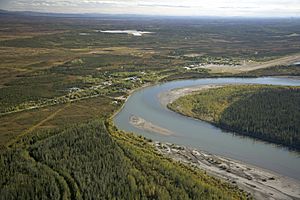
Aerial view of Evansville (left) and its neighbor Bettles (right)
|
|

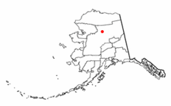
Location of Evansville, Alaska
|
|
| Country | United States |
| State | Alaska |
| Census Area | Yukon-Koyukuk |
| Area | |
| • Total | 23.17 sq mi (60.01 km2) |
| • Land | 22.98 sq mi (59.51 km2) |
| • Water | 0.20 sq mi (0.50 km2) |
| Population
(2020)
|
|
| • Total | 12 |
| • Density | 0.52/sq mi (0.20/km2) |
| Time zone | UTC-9 (Alaska (AKST)) |
| • Summer (DST) | UTC-8 (AKDT) |
| ZIP code |
99726
|
| Area code(s) | 907 |
| FIPS code | 02-23790 |
Evansville is a small community in Alaska, United States. It is known as a census-designated place (CDP). This means it is a special area set up by the government for counting people. Evansville is located in the Yukon-Koyukuk Census Area.
In 2020, only 12 people lived in Evansville. This number was 15 in 2010 and 28 in 2000. The community is right next to another town called Bettles. Evansville got its name from Wilford Evans, Sr. He helped start a place called Bettles Lodge.
Contents
Geography of Evansville, Alaska
Evansville is found on the southeast side of the Koyukuk River. It is located at about 66.9 degrees North and 151.5 degrees West. This puts it far north, about 35 miles (56 km) north of the Arctic Circle. The Arctic Circle is an imaginary line around the Earth where the sun does not set for at least one day in summer.
Location and Surroundings
Evansville is just south of the Brooks Range, a large mountain range. This area is also home to the Gates of the Arctic National Park and Preserve. This park is a huge protected wilderness area.
The community is on what used to be the Hickel Highway. Today, this road connects to the Dalton Highway only in winter. It becomes an "ice road" when the ground and rivers freeze solid. This allows vehicles to drive over ice and frozen land.
Land and Water Area
The United States Census Bureau says that Evansville covers about 22.4 square miles (58 square kilometers). Most of this area, about 22.2 square miles (57.5 square kilometers), is land. A small part, about 0.2 square miles (0.5 square kilometers), is water.
Climate in Evansville
Evansville has a subarctic climate. This means it has very long, cold winters and short, warm summers. The weather here is similar to much of Interior Alaska.
Temperature Extremes
Temperatures usually stay below freezing from late October to late March. The coldest temperature ever recorded was -70°F (-57°C) on January 4, 1975. Summers can be warm, with temperatures reaching 70°F (21°C) on many days. The hottest temperature ever recorded was 93°F (34°C) on July 6, 1986.
Snowfall and Rain
Most of the snow falls from October to April. The average yearly snowfall is about 91 inches (2.3 meters). Lighter snow can also fall in May and September. The area gets about 14.9 inches (37.8 cm) of rain each year. Most of this rain happens during the summer months.
| Climate data for Evansville (Bettles Airport), Alaska (1991–2020 normals, extremes 1944–present) | |||||||||||||
|---|---|---|---|---|---|---|---|---|---|---|---|---|---|
| Month | Jan | Feb | Mar | Apr | May | Jun | Jul | Aug | Sep | Oct | Nov | Dec | Year |
| Record high °F (°C) | 42 (6) |
40 (4) |
49 (9) |
66 (19) |
86 (30) |
92 (33) |
93 (34) |
88 (31) |
79 (26) |
59 (15) |
45 (7) |
38 (3) |
93 (34) |
| Mean maximum °F (°C) | 26.1 (−3.3) |
29.7 (−1.3) |
35.1 (1.7) |
51.9 (11.1) |
73.5 (23.1) |
82.5 (28.1) |
83.7 (28.7) |
75.9 (24.4) |
64.5 (18.1) |
45.2 (7.3) |
28.5 (−1.9) |
26.4 (−3.1) |
85.0 (29.4) |
| Mean daily maximum °F (°C) | −2.4 (−19.1) |
6.5 (−14.2) |
16.6 (−8.6) |
35.9 (2.2) |
55.7 (13.2) |
69.9 (21.1) |
70.2 (21.2) |
62.6 (17.0) |
49.8 (9.9) |
28.4 (−2.0) |
7.6 (−13.6) |
1.9 (−16.7) |
33.6 (0.9) |
| Daily mean °F (°C) | −10.6 (−23.7) |
−3.4 (−19.7) |
3.7 (−15.7) |
24.6 (−4.1) |
45.0 (7.2) |
58.6 (14.8) |
59.8 (15.4) |
52.7 (11.5) |
41.2 (5.1) |
21.3 (−5.9) |
0.3 (−17.6) |
−6.0 (−21.1) |
23.9 (−4.5) |
| Mean daily minimum °F (°C) | −18.9 (−28.3) |
−13.3 (−25.2) |
−9.2 (−22.9) |
13.2 (−10.4) |
34.2 (1.2) |
47.3 (8.5) |
49.4 (9.7) |
42.7 (5.9) |
32.6 (0.3) |
14.3 (−9.8) |
−7.0 (−21.7) |
−13.9 (−25.5) |
14.3 (−9.8) |
| Mean minimum °F (°C) | −50.1 (−45.6) |
−40.6 (−40.3) |
−33.2 (−36.2) |
−13.5 (−25.3) |
18.0 (−7.8) |
36.0 (2.2) |
38.8 (3.8) |
28.9 (−1.7) |
17.2 (−8.2) |
−9.9 (−23.3) |
−31.4 (−35.2) |
−42.4 (−41.3) |
−53.4 (−47.4) |
| Record low °F (°C) | −70 (−57) |
−64 (−53) |
−56 (−49) |
−39 (−39) |
−10 (−23) |
27 (−3) |
29 (−2) |
15 (−9) |
0 (−18) |
−35 (−37) |
−57 (−49) |
−60 (−51) |
−70 (−57) |
| Average precipitation inches (mm) | 0.87 (22) |
0.96 (24) |
0.61 (15) |
0.60 (15) |
0.89 (23) |
1.46 (37) |
2.32 (59) |
2.71 (69) |
2.13 (54) |
1.17 (30) |
1.15 (29) |
1.14 (29) |
16.01 (407) |
| Average snowfall inches (cm) | 14.0 (36) |
15.9 (40) |
9.3 (24) |
5.2 (13) |
1.0 (2.5) |
0.0 (0.0) |
0.0 (0.0) |
0.0 (0.0) |
3.2 (8.1) |
12.0 (30) |
19.1 (49) |
18.2 (46) |
97.9 (249) |
| Average precipitation days (≥ 0.01 in) | 9.1 | 9.8 | 7.8 | 6.2 | 8.6 | 11.4 | 13.4 | 15.2 | 12.9 | 12.4 | 10.7 | 11.4 | 128.9 |
| Average snowy days (≥ 0.1 in) | 10.5 | 10.8 | 8.6 | 5.0 | 1.3 | 0 | 0 | 0 | 2.6 | 11.1 | 11.8 | 12.6 | 74.3 |
| Average relative humidity (%) | 68.6 | 67.0 | 65.3 | 67.2 | 60.7 | 59.8 | 67.7 | 75.8 | 75.6 | 77.7 | 73.5 | 71.7 | 69.2 |
| Average dew point °F (°C) | −17.3 (−27.4) |
−16.1 (−26.7) |
−6.5 (−21.4) |
11.8 (−11.2) |
29.7 (−1.3) |
42.4 (5.8) |
47.8 (8.8) |
45.0 (7.2) |
32.5 (0.3) |
12.7 (−10.7) |
−7.4 (−21.9) |
−15.5 (−26.4) |
13.3 (−10.4) |
| Source: NOAA (relative humidity and dew point 1961–1990) | |||||||||||||
Population of Evansville
Evansville first appeared on the U.S. Census in 1970. Back then, it was just a small village. In 1980, it became a census-designated place (CDP).
| Historical population | |||
|---|---|---|---|
| Census | Pop. | %± | |
| 1970 | 57 | — | |
| 1980 | 94 | 64.9% | |
| 1990 | 33 | −64.9% | |
| 2000 | 28 | −15.2% | |
| 2010 | 15 | −46.4% | |
| 2020 | 12 | −20.0% | |
| U.S. Decennial Census | |||
Population Changes Over Time
The number of people living in Evansville has changed quite a bit. In 1980, the population was 94 people. By 2020, it had dropped to just 12 people. This shows how small and remote the community is.
Community Makeup in 2000
In the year 2000, there were 28 people living in Evansville. They lived in 12 different homes. About half of the people were White, and half were Native American. A small number were from two or more races.
The average home had about 2 to 3 people. About a quarter of the homes had children under 18. The median age of people in Evansville was 34 years old. This means half the people were younger than 34 and half were older.
Getting Around Evansville
Even though Evansville is small, it has ways to connect to other places.
Air Travel
The nearby Bettles Airport offers flights. Wright Air Service provides daily flights. You can fly to and from Fairbanks and other communities. There is also a place for seaplanes called Vor Lake Waterlane.
Education in Evansville
Evansville used to have its own school. It was called the Bettles Field School. It was part of the Yukon–Koyukuk School District. However, the school closed down. This happened in the 2002-2003 school year. It closed because there were not enough students to keep it open.
See also
 In Spanish: Evansville (Alaska) para niños
 | James B. Knighten |
 | Azellia White |
 | Willa Brown |

