Tropic of Capricorn facts for kids
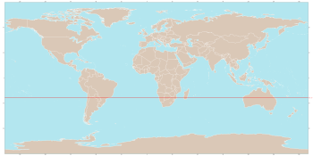
The Tropic of Capricorn, also called the Southern Tropic, is an important imaginary line on Earth's map. It's one of five main circles of latitude. This line is located about 23.5 degrees south of the Equator.
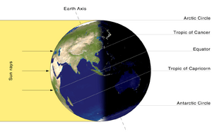
This special line shows the furthest point south where the sun can be directly overhead. This happens once a year during the December solstice. At this time, the southern half of the Earth is tilted most towards the sun.
Contents
Where is the Tropic of Capricorn?
The Tropic of Capricorn passes through many countries and territories. If you start at the prime meridian and travel west, you would cross these places:
- Brazil
- Paraguay
- Argentina
- Chile
- French Polynesia (just south of Tubuai)
- Tonga (just north of the Minerva Reefs)
- Coral Sea Islands Territory (Australia) (just south of Cato Reef)
- Australia
- Madagascar
- Mozambique
- South Africa
- Botswana
- Namibia
Why is it Called the Tropic of Capricorn?
The Tropic of Capricorn got its name about 2,000 years ago. Back then, during the December solstice, the sun appeared to enter the constellation Capricornus.
Today, because of a slow wobble in Earth's axis called precession of the equinoxes, the sun actually appears in the constellation Sagittarius during the December solstice.
The word "tropic" comes from the Greek word tropos, which means "turn." This refers to how the sun seems to "turn back" after reaching its furthest point north or south at the solstices.
Related Pages
- Southern Hemisphere
- Eastern Hemisphere
- Western Hemisphere
- Seasons
- Solstice and equinox
- Equator
- Tropics
- Tropic of Cancer
- Northern Hemisphere
- Arctic Circle
- Antarctic Circle
Images for kids
See also
 In Spanish: Trópico de Capricornio para niños
 | Janet Taylor Pickett |
 | Synthia Saint James |
 | Howardena Pindell |
 | Faith Ringgold |


