
Madagascar facts for kids
Quick facts for kids
Republic of Madagascar
|
|
|---|---|
 Emblem
|
|
|
Motto:
|
|
|
Anthem: Ry Tanindrazanay malala ô ! (Malagasy)
Ô Terre de nos ancêtres bien-aimés! (French) "Oh, land of our beloved ancestors!" |
|
.svg)
Location of Madagascar (dark green)
|
|
| Capital and largest city
|
Antananarivo 18°55′S 47°31′E / 18.917°S 47.517°E |
| Official languages | |
| Ethnic groups
(2017)
|
|
| Religion
(2020)
|
|
| Demonym(s) | Malagasy |
| Government | Unitary semi-presidential republic under a transitional government |
| Michael Randrianirina | |
| Vacant | |
| Legislature | Parliament |
| Senate (suspended) | |
| National Assembly | |
| Formation | |
|
• Kingdom
|
c. 1540 |
|
• French protectorate
|
c. 1882 |
|
• French colony
|
6 August 1896 |
|
• Republic proclaimed
|
14 October 1958 |
| 26 June 1960 | |
|
• Referendum
|
21 December 1975 |
|
• Socialist state
|
30 December 1975 – 12 January 1992 |
|
• Third Republic
|
12 January 1992 – 11 December 2010 |
|
• Referendum
|
17 November 2010 |
|
• Current constitution
|
11 December 2010 |
|
• 2025 Malagasy protests
|
25 September – 14 October 2025 |
|
• Coup d'etat
|
12–14 October 2025 |
| Area | |
|
• Total
|
592,796 km2 (228,880 sq mi) (46th) |
|
• Water
|
5,501 km2 (2,124 sq mi) |
|
• Water (%)
|
0.9% |
| Population | |
|
• 2024 estimate
|
31,964,956 (49th) |
|
• Density
|
55/km2 (142.4/sq mi) (164th) |
| GDP (PPP) | 2026 estimate |
|
• Total
|
|
|
• Per capita
|
|
| GDP (nominal) | 2026 estimate |
|
• Total
|
|
|
• Per capita
|
|
| Gini (2012) | ▼ 42.6 medium |
| HDI (2023) | low · 183rd |
| Currency | Ariary (MGA) |
| Time zone | UTC+3 (EAT) |
| Date format | dd/mm/yyyy |
| Driving side | right |
| Calling code | +261 |
| ISO 3166 code | MG |
| Internet TLD | .mg |


Madagascar is a very large island nation. It is located in the Indian Ocean, off the east coast of Africa. About 32 million people live there. Its capital city is Antananarivo. Madagascar is the fourth largest island in the world.
The official languages spoken are Malagasy and French. Scientists believe that Madagascar was once part of a huge landmass. This landmass included what is now Africa. But it broke away about 180 million years ago. Later, Madagascar also separated from the Indian subcontinent.
Contents
Madagascar's Past: A Brief History
After the supercontinent Gondwana broke apart, Madagascar split from Africa. This happened around 180 million years ago. It then separated from the Indian subcontinent about 90 million years ago. This long isolation allowed its unique plants and animals to develop. That is why Madagascar is a "biodiversity hotspot." Over 90% of its wildlife is found nowhere else.
The first people settled in Madagascar around 1,500 to 2,000 years ago. They were likely Austronesian peoples from what is now Indonesia. Later, Bantu migrants from East Africa joined them. Over time, other groups also settled on the island. Each group added to Madagascar's rich culture. Today, there are 18 or more main ethnic groups. The largest group is the Merina, who live in the central highlands.
For a long time, Madagascar was ruled by many small groups. In the early 1800s, most of the island became united. It was known as the Merina Kingdom. France took control in 1897, making it a French colony. Madagascar gained its independence in 1960. Since then, it has been a constitutional democracy.
Exploring Madagascar's Geography
Madagascar covers about 592,800 square kilometers. This makes it the world's 47th largest country. It is also the fourth-largest island. The island is located between 12°S and 26°S latitude. It is also between 43°E and 51°E longitude. Nearby islands include Réunion and Mauritius to the east. Comoros and Mayotte are to the northwest. The closest country on the mainland is Mozambique to the west.
A narrow, steep cliff runs along the eastern coast. This area has most of the island's remaining tropical lowland forest. West of this ridge is a plateau in the center of the island. It is about 750 to 1,500 meters above sea level. These central highlands are home to the Merina people. The capital city, Antananarivo, is also here. This is the most populated part of the island. It has terraced valleys for growing rice, grassy hills, and patches of subhumid forests.
West of the highlands, the land becomes drier. It slopes down to the Mozambique Channel. This area has mangrove swamps along the coast. Madagascar's highest peaks are in three main mountain areas. Maromokotro is the highest point at 2,876 meters. It is in the Tsaratanana Massif.
The western and southern parts of the island are drier. They are in the rain shadow of the central highlands. These areas have dry deciduous forests, spiny forests, and deserts and xeric shrublands. The dry forests in the west have been better preserved than the eastern rainforests. The western coast has many protected harbors. However, sediment from river erosion causes a lot of silting.
Madagascar's Climate

Madagascar has two main seasons. A hot, rainy season lasts from November to April. This season often brings strong cyclones. A cooler, dry season lasts from May to October. Rain clouds from the Indian Ocean drop most of their moisture on the eastern coast. This heavy rain supports the area's rainforest ecosystem. The central highlands are drier and cooler. The west is even drier, and the southwest has a semi-arid climate.
Tropical cyclones hit Madagascar every year. They cause damage to buildings and the economy. They also lead to loss of life. In 2004, Cyclone Gafilo was the strongest cyclone to hit Madagascar. It killed 172 people and left many homeless.
Amazing Biodiversity and Conservation Efforts

Madagascar has been separated from other continents for a very long time. Because of this, it is home to many unique plants and animals. About 90% of all species found here live nowhere else on Earth. This special environment has led some scientists to call Madagascar the "eighth continent." It is known as a "biodiversity hotspot."
More than 80% of Madagascar's 14,883 plant species are found only there. This includes five entire plant families. For example, the Didiereaceae family, with 11 species, only grows in the spiny forests of southwestern Madagascar. Three-fourths of Madagascar's 860 orchid species are unique to the island. Six of the world's nine baobab species also grow here. The island has about 170 palm species, and 165 of them are endemic. Many native plants are used as traditional medicines. The drugs vinblastine and vincristine, used to treat cancers, come from the Madagascar periwinkle. The traveler's palm, called ravinala, is a symbol of Madagascar. It is even on the national emblem.

Madagascar's animals are also very diverse and unique. Lemurs are often called "Madagascar's flagship mammal species." Since there were no monkeys or other similar animals, lemurs adapted to many different habitats. They evolved into many species. As of 2012, there were 103 known species and subspecies of lemurs. Almost all of them are rare, vulnerable, or endangered. At least 17 lemur species have become extinct since humans arrived.
Other unique mammals, like the cat-like fossa, also live only in Madagascar. Over 300 bird species have been recorded on the island. More than 60% of these are found nowhere else. The island is home to two-thirds of the world's chameleon species. This includes the smallest known chameleon.
Madagascar's unique plants and animals are in danger from human activities. Since humans arrived about 2,350 years ago, Madagascar has lost over 90% of its original forests. This forest loss is mainly due to tavy, a traditional slash-and-burn farming method. Farmers use this method for agriculture and because it is part of their culture. As more people lived on the island, deforestation sped up. By the 16th century, the central highlands were mostly cleared of their forests.


Other reasons for forest loss include more cattle, using charcoal for cooking, and growing coffee as a cash crop. From the 1950s to 2000, about 40% of the island's original forest cover was lost. Protecting wildlife is also hard because of illegal logging in protected forests.
New species brought by humans also threaten native wildlife. For example, the Asian common toad was found in Madagascar in 2014. Researchers warned it could harm the country's unique animals. Habitat destruction and hunting have threatened many species. The island's giant elephant birds became extinct around the 17th century. This was likely due to human hunting and egg poaching. Many giant lemur species also disappeared after humans arrived.
In 2003, former President Marc Ravalomanana announced a plan. He wanted to triple the island's protected natural areas. By 2011, state-protected areas included five Strict Nature Reserves, 21 Wildlife Reserves, and 21 National Parks. In 2007, six national parks were named a World Heritage Site. These are Marojejy, Masoala, Ranomafana, Zahamena, Andohahela, and Andringitra.
Madagascar's Economy

Agriculture is a very important part of Madagascar's economy. Farmers grow crops like coffee and vanilla. Madagascar sells more vanilla than any other country in the world. The country also earns money from tourism.
How Madagascar is Divided
Madagascar is divided into 22 regions, called faritra. These regions are then split into 119 districts. Below that are 1,579 communes and 17,485 fokontany.

| New regions | Former provinces |
Area in km2 |
Population 2018 |
|---|---|---|---|
| Diana | Antsiranana | 19,993 | 889,962 |
| Sava | Antsiranana | 23,794 | 1,123,772 |
| Itasy | Antananarivo | 6,579 | 898,549 |
| Analamanga | Antananarivo | 17,346 | 3,623,925 |
| Vakinankaratra | Antananarivo | 17,884 | 2,079,659 |
| Bongolava | Antananarivo | 18,096 | 670,993 |
| Sofia (7) | Mahajanga | 50,973 | 1,507,591 |
| Boeny | Mahajanga | 31,250 | 929,312 |
| Betsiboka | Mahajanga | 28,964 | 393,278 |
| Melaky | Mahajanga | 40,863 | 308,944 |
| Alaotra Mangoro | Toamasina | 27,846 | 1,249,931 |
| Atsinanana | Toamasina | 22,031 | 1,478,472 |
| Analanjirofo | Toamasina | 21,666 | 1,150,089 |
| Amoron'i Mania | Fianarantsoa | 16,480 | 837,116 |
| Haute-Matsiatra | Fianarantsoa | 20,820 | 1,444,587 |
| Vatovavy-Fitovinany | Fianarantsoa | 20,740 | 1,440,657 |
| Atsimo-Atsinanana | Fianarantsoa | 16,632 | 1,030,404 |
| Ihorombe | Fianarantsoa | 26,046 | 418,520 |
| Menabe | Toliara | 48,814 | 692,463 |
| Atsimo-Andrefana | Toliara | 66,627 | 1,797,894 |
| Androy | Toliara | 18,949 | 900,235 |
| Anosy | Toliara | 29,505 | 809,051 |
| Totals | 591,896 | 25,674,196 |
How Madagascar is Governed

Madagascar is a semi-presidential representative democracy. This means the people elect a president, who is the head of state. The president then chooses a prime minister. The prime minister suggests people to form the government's cabinet. The country's constitution sets up three independent parts of government: the executive (president and cabinet), legislative (parliament), and judicial (courts).
The public directly elects the president and the 151 members of the National Assembly. They serve five-year terms. The Senate has 18 members. 12 senators are elected by local officials, and 6 are chosen by the president. They serve six-year terms.
At the local level, the 22 provinces are run by a governor and a council. The provinces are further divided into regions and communes. The court system is based on the French system. It includes a High Constitutional Court, Supreme Court, and other courts. Antananarivo is the capital and largest city.
People and Culture of Madagascar
Who Lives in Madagascar?

In 2024, Madagascar's population was estimated to be 32 million people. This is a big increase from 2.2 million in 1900. The population grows by about 2.4% each year.
The Malagasy ethnic group makes up over 90% of the population. They are usually divided into 18 smaller groups. DNA research shows that most Malagasy people have a mix of Southeast Asian and East African genes. Some communities also have Arab, Indian, or European ancestors.
| Malagasy ethnic subgroups | Regional concentration |
|---|---|
| Antankarana, Sakalava, Tsimihety | Northern and northwestern coasts |
| Sakalava, Vezo | Western coast |
| Betsimisaraka, Sihanaka, Bezanozano | Eastern coast |
| Merina | Central highlands |
| Betsileo, Antaifasy, Antambahoaka, Antaimoro, Antaisaka, Tanala | Southeastern coast |
| Mahafaly, Antandroy, Antanosy people, Bara, Vezo | Southern inland regions and coast |
Major Cities in Madagascar
|
Largest cities or towns in Madagascar
According to the 2018 Census |
||
|---|---|---|
| Rank | Name | Pop. |
| 1 | Antananarivo | 1,275,207 |
| 2 | Toamasina | 326,286 |
| 3 | Antsirabe | 245,592 |
| 4 | Mahajanga | 244,722 |
| 5 | Fianarantsoa | 189,879 |
| 6 | Toliara | 169,760 |
| 7 | Antsiranana | 131,165 |
| 8 | Hell-Ville | 109,365 |
| 9 | Sambava | 85,659 |
| 10 | Taolagnaro | 67,188 |
Languages Spoken
.jpg)
The Malagasy language comes from the Malayo-Polynesian language family. It is spoken all over the island.
French became an official language when France ruled Madagascar. In the first constitution of 1958, Malagasy and French were both official. Madagascar is a francophone country. Educated people often speak French as a second language. It is used for talking with other countries. In big cities, some upper-class people speak French as their first language.
The Constitution of 2007 added English as an official language. However, a new constitution in 2010 recognized only Malagasy and French.
Religions in Madagascar


Christianity is the most common religion in Madagascar. In 2020, about 85% of people were Christian. About 3% of the population were Muslims. They mostly live in the northwestern provinces of Mahajanga and Antsiranana.
Education for Kids
_Madagascar.jpg)
Before the 1800s, education in Madagascar was informal. Children learned practical skills and cultural values. The first formal European-style school opened in 1818. It was started by the London Missionary Society (LMS). King Radama I invited the LMS to open more schools. They taught reading and math to noble children.
By the late 1800s, Madagascar had a very modern school system for its time. During the colonial period, schooling expanded in coastal areas. The focus was on French language and basic work skills. After independence, there was a push to use Malagasy in schools. This led to a big change in the education system.
Education became a priority under President Ravalomanana (2002–2009). It is now free and required for children aged 6 to 13. Primary school lasts five years. Then there are four years of lower secondary school and three years of upper secondary school. Many new schools and classrooms were built. Old buildings were fixed. Thousands of new teachers were hired and trained. Primary school fees were removed, and school supplies were given to students.
The government made sure there is at least one primary school in every fokontany. There is also a lower secondary school in each commune. Larger towns have at least one upper secondary school. Madagascar has public universities in Antananarivo, Mahajanga, and Fianarantsoa. There are also teacher-training colleges and private universities.
Because of these efforts, school enrollment more than doubled between 1996 and 2006. However, the quality of education still needs improvement. Many students repeat grades or drop out. The government is working to improve teaching methods. In 2014, public spending on education was 2.8% of the country's GDP. About 64.7% of people can read and write.
Malagasy Culture and Traditions
Each ethnic group in Madagascar has its own beliefs and ways of life. But there are many shared cultural features across the island. These create a strong Malagasy identity. People share a common language and traditional religious beliefs. They believe in a creator god and respect their ancestors. The Malagasy worldview also values fihavanana (solidarity), vintana (destiny), tody (karma), and hasina. Hasina is a sacred life force that gives authority to community leaders. Other common cultural elements include strong family ties. People also widely believe in magic, fortune tellers, and traditional healers.
The diverse origins of Malagasy culture can be seen in its art and traditions. The most famous instrument is the valiha. It is a bamboo tube zither. It was brought to Madagascar by early settlers from Borneo. It looks very similar to instruments found in Indonesia and the Philippines today. Traditional houses in Madagascar are also similar to those in Borneo. They are rectangular with a peaked roof and a central support pillar. Tombs are very important culturally. They are often built from strong materials like stone. They are also more decorated than living houses. This shows respect for ancestors. Making and weaving silk has been done since the first settlers arrived. Madagascar's national dress, the woven lamba, is a beautiful art form.
Southeast Asian culture also influences Malagasy cuisine. Rice (vary) is eaten with every meal. It is usually served with a side dish (laoka). Laoka can be vegetarian or include meat. It often has flavors like ginger, onion, garlic, tomato, or vanilla. In some dry southern and western areas, people eat corn, cassava, or fermented zebu milk instead of rice. Many sweet and savory fried snacks are sold on the streets. There are also many tropical fruits. Local drinks include fruit juices, coffee, herbal teas, and alcoholic drinks like rum, wine, and beer. Three Horses Beer is the most popular beer and a symbol of Madagascar.
Sports and Games

Madagascar has many traditional pastimes. Moraingy is a type of hand-to-hand combat. It is a popular sport in coastal areas. Traditionally, men practiced it, but now women also join in. The wrestling of zebu cattle, called savika or tolon-omby, is also popular.
Besides sports, many games are played. One of the most famous is fanorona. It is a board game popular in the highlands. Legend says that King Andrianjaka became king partly because his older brother was too busy playing fanorona.
Western sports were introduced to Madagascar in the last two centuries. Rugby union is considered the national sport. Soccer is also popular. Madagascar has a world champion in pétanque. This is a French game similar to lawn bowling. It is widely played in cities and the highlands. School sports programs often include soccer, track and field, judo, boxing, and tennis. Madagascar first sent athletes to the Olympic Games in 1964. They also compete in the African Games.
Antananarivo has good sports facilities. It has hosted several major African basketball events. This includes the 2011 FIBA Africa Championship. Madagascar's national 3x3 basketball team won the gold medal at the 2019 African Games.
Related pages
Images for kids
-

Biogeographic timetable of Madagascar over the last 200 million years
-
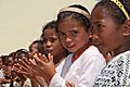
Malagasy people have a mix of Southeast Asian and African roots.
-
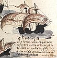
Europeans first arrived in 1500. Portuguese explorer Diogo Dias saw the island during his travels.
-
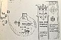
Matatana, shown in a 1613 picture, was a settlement from the early 16th century.
-
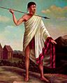
King Andrianampoinimerina (1787–1810)
-
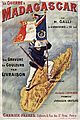
A French poster about the Franco-Hova War.
-
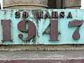
This monument in Moramanga remembers the start of the Malagasy Uprising in 1947.
-

Philibert Tsiranana, the first president of Madagascar (1960-72).
-
Nosy Iranja is a popular place for tourists in Madagascar.
-
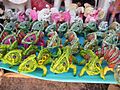
Toy animals made from raffia, a native palm tree.
-
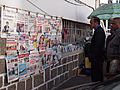
A news stand in Antananarivo.
-
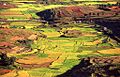
Terraced emerald paddy fields
-
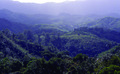
Rainforest, Madagascar
-

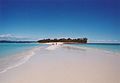
White sand beach in Madagascar
-
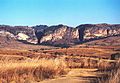
Isalo canyons
-

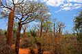
Giant baobabs near Morondava, Madagascar
-
Succulents growing sparsely


.jpg)


See also
 In Spanish: Madagascar para niños
