
Dempster Highway facts for kids
Quick facts for kids
|
|||||||
|---|---|---|---|---|---|---|---|
| Yukon Highway 5 Northwest Territories Highway 8 |
|||||||
| Lua error in Module:Infobox_road/map at line 15: attempt to index field 'wikibase' (a nil value). | |||||||
| Route information | |||||||
| Length | 737.5 km (458.3 mi)
YT-5: 465 km (289 mi)
NWT-8: 271 km (168 mi) |
||||||
| Major junctions | |||||||
| South end | |||||||
| North end | |||||||
| Highway system | |||||||
| Territorial highways in Yukon Miscellaneous
|
|||||||


The Dempster Highway is a famous road in Canada. It connects the Klondike Highway in Yukon to Inuvik in the Northwest Territories. This highway is special because it crosses two big rivers, the Peel and the Mackenzie River. To cross them, people use ferries in summer and ice bridges in winter!
In 2017, a new road called the Inuvik–Tuktoyaktuk Highway opened. This meant you could drive all the way from the rest of Canada to Tuktoyaktuk on the Arctic Ocean. The Dempster Highway is named after William Dempster, an officer from the North-West Mounted Police. He was known for finding a lost patrol in 1911.
Contents
What is the Dempster Highway?
The Dempster Highway starts about 40 km (25 mi) east of Dawson City in Yukon. It stretches for about 736 km (457 mi) towards the north. Along the way, it passes through amazing places like Tombstone Territorial Park. It also crosses the Ogilvie Mountains and Richardson Mountains. There are no other major roads that cross the Dempster Highway.
History of the Dempster Highway

The Dempster Highway follows an old route that dog sled teams used to take. This route went from Dawson City to Fort McPherson. The road is named after Corporal William Dempster. He was part of the North-West Mounted Police, which was like Canada's police force back then.
In the late 1800s, during the Klondike Gold Rush, the North-West Mounted Police set up posts in Yukon and the Northwest Territories. They used dog sleds to travel between these posts, even in winter. One common route was from Dawson City to Fort McPherson.
In December 1910, an officer named Francis Joseph Fitzgerald led a patrol of three men from Fort McPherson to Dawson City. Sadly, they got lost in the snow and died from the cold and hunger. When they didn't arrive, Corporal Dempster and two other officers went to look for them in March 1911. On March 22, 1911, Dempster and his team found the lost patrol.
Building the Dempster Highway

In 1958, people were looking for oil and gas in the Mackenzie River area. The Canadian government decided to build a road to connect Dawson City to Aklavik (later changed to Inuvik). The idea was to have a road that could be used all year to bring supplies to the north. Building started in 1959.
Work was slow at first because it was very expensive. It also stopped for a while in 1962. In 1964, the road was officially named the Dempster Highway. Building started again in 1970. This was partly because the Canadian government wanted to show it controlled its Arctic lands. It was also because people thought an oil pipeline might be built there.
Building this highway was a huge challenge. It was the most northern major road project at the time. The weather was extreme, with very cold temperatures and long periods of darkness in winter. Workers even got trapped in a blizzard once!
A big problem was building on permafrost. This is ground that is frozen all the time. If the road got too warm, the permafrost would melt and the road would sink. To stop this, they built the road on a thick layer of gravel. This gravel acted like insulation, keeping the permafrost frozen. Even the Canadian Forces helped build some bridges!
The last part of the road was finished in 1978. The Dempster Highway officially opened on August 18, 1979.
Gallery
-
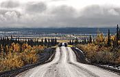
Dempster Highway south of Inuvik
-
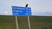
Sign on Dempster Highway
-
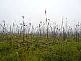
Arctic spruce
-
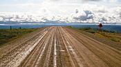
Dempster Highway
-
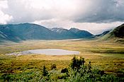
Tombstone Mountains from Highway
-
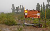
Sign in Eagle Plains: "High winds and blowing snow"
-
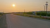
Midnight sun over the Dempster near Inuvik


Major intersections
| County | Location | Kilometre | Roads intersected | Notes | ||
|---|---|---|---|---|---|---|
| unorganized | ||||||
| North Fork Pass – 1,289 m (4,229 ft) | Highest point on the Dempster Highway | |||||
| Eagle Plains | First available services | |||||
| Uses a portion of the highway as its runway. | ||||||
| 405 | 252 | Arctic Circle | ||||
| Yukon – Northwest Territories border | 465 | 289 | One hour time change (summer only) |
|||
| Northwest Territories | Inuvik | | 539 | 335 | Crosses the Peel River |
|
| Fort McPherson | Second and last available services | |||||
| Tsiigehtchic | 608 | 378 | Crosses the Mackenzie River |
|||
| Inuvik | ||||||
| 1.000 mi = 1.609 km; 1.000 km = 0.621 mi | ||||||
See also
- List of Yukon territorial highways
- Dalton Highway – the only other all-season highway to cross the Arctic Circle in North America
