Fort McPherson, Northwest Territories facts for kids
Quick facts for kids
Fort McPherson
Teetł'it Zheh
The heart of the Gwichʼin
|
|
|---|---|

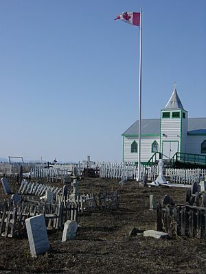
A wooden church in Fort McPherson, NWT
|
|
| Motto(s):
"Take what you need"
|
|
| Country | Canada |
| Territory | Northwest Territories |
| Region | Inuvik Region |
| Constituency | Mackenzie Delta |
| Census division | Region 1 |
| Hamlet | 1 November 1986 |
| Area | |
| • Land | 53.83 km2 (20.78 sq mi) |
| Elevation | 43 m (141 ft) |
| Population
(2021)
|
|
| • Total | 647 |
| • Density | 12.0/km2 (31/sq mi) |
| Time zone | UTC−07:00 (MST) |
| • Summer (DST) | UTC−06:00 (MDT) |
| Canadian Postal code |
X0E 0J0
|
| Area code(s) | 867 |
| Telephone exchange | 952 |
| - Living cost (2018) | 162.5 |
| - Food price index | 162.8 |
| Website | www.fortmcpherson.ca |
| Sources: Department of Municipal and Community Affairs, Prince of Wales Northern Heritage Centre, Canada Flight Supplement 2018 figure based on Edmonton = 100 2019 figure based on Yellowknife = 100 |
|
| Official name: Fort McPherson National Historic Site of Canada | |
| Designated: | 1969 |
Fort McPherson is a small community, or hamlet, located in the Northwest Territories of Canada. Its name in the Gwich'in language is Teetł'it Zheh, which means "at the head of the waters."
This hamlet is found on the east side of the Peel River. It is about 121 kilometers (75 miles) south of Inuvik along the Dempster Highway. Most people living here are First Nations, mainly from the Gwich'in (Teetł'it Gwich'in) group. The main languages spoken are Gwich'in and English.
Fort McPherson was originally a trading post for the Hudson's Bay Company. It was named after Murdoch McPherson. Many residents own vehicles and often travel to nearby towns like Inuvik or Whitehorse, Yukon.
Contents
Exploring Fort McPherson's Past
Fort McPherson has an interesting history. It was the starting point for a famous and sad journey known as "The Lost Patrol."
The Lost Patrol Story
In 1910, a group of four Royal Northwest Mounted Police officers, led by Francis Joseph Fitzgerald, set out from Fort McPherson. They were on a long patrol, but they got lost and sadly did not survive. All four men were buried in Fort McPherson on March 28, 1911. Later, in 1938, their graves were covered with cement to create one large tomb. A memorial stands in the center to remember the patrol.
A National Historic Site
In 1969, the area of Fort McPherson, as it was mapped in 1898, was named a National Historic Site of Canada. This is because it was a very important trading post for the Hudson's Bay Company in the MacKenzie Delta region for over 50 years. It was also the first police post for the North-West Mounted Police in the Western Arctic.
Getting Around Fort McPherson
Fort McPherson is connected to other places by road and air.
Road Access
You can reach Fort McPherson by road all year from Dawson City and Whitehorse, Yukon. However, there are times in spring and fall when the ice on the Peel River breaks up or freezes. During these times, the road across the river is closed. The community is also connected to Inuvik via the Dempster Highway. To get there, you cross the Mackenzie River at Tsiigehtchic.
Air Travel
Fort McPherson also has a small airport called Fort McPherson Airport. During the times when the road across the Peel River is closed, there are seasonal flights to Inuvik (Mike Zubko) Airport on Aklak Air. There used to be a water airport, but it closed in 2007.
People of Fort McPherson
Let's look at the population of Fort McPherson.
Population Numbers
According to the 2021 Census, Fort McPherson had a population of 647 people. This was a small decrease from its population of 700 people in 2016. The community covers a land area of about 53.83 square kilometers (20.78 square miles).
Indigenous Population
In the 2016 Census, 695 people in Fort McPherson identified as Indigenous.
- 610 people were First Nations.
- 15 people were Métis.
- 20 people were Inuit or Inuvialuit.
- 10 people identified with multiple or other Indigenous groups.
- 40 people were not Indigenous.
Population Changes Over Time
The population of Fort McPherson has changed over the years:
- 1976: 710
- 1981: 623
- 1986: 760
- 1991: 759
- 1996: 878
- 2001: 773
- 2006: 776
- 2011: 792
- 2016: 700
- 2021: 647
Fort McPherson's Climate
Fort McPherson has a subarctic climate. This means it has very cold, long winters and short, cool summers.
Temperature Extremes
The highest temperature ever recorded in Fort McPherson was 35.1 degrees Celsius (95.2 degrees Fahrenheit) on August 6, 2024. The coldest temperature ever recorded was a very chilly -55.6 degrees Celsius (-68.1 degrees Fahrenheit) on January 14, 1894.
See also
 In Spanish: Fort McPherson (Territorios del Noroeste) para niños
 | Chris Smalls |
 | Fred Hampton |
 | Ralph Abernathy |


