
Dawson City facts for kids
Quick facts for kids
Dawson City
|
|
|---|---|
|
City
|
|
| City of Dawson | |

Aerial view of Dawson City and the Yukon River
|
|
| Nickname(s):
Paris of the North
|
|

Dawson City
Location in Yukon
|
|
| Country | Canada |
| Territory | Yukon |
| Settled | 1896 |
| City | 1902 |
| Town | 1980 |
| Named for | George Mercer Dawson |
| Area | |
| • Total | 32.45 km2 (12.53 sq mi) |
| Elevation | 370 m (1,214 ft) |
| Population
(2016)
|
|
| • Total | 1,577 |
| • Density | 42.4/km2 (110/sq mi) |
| Time zone | UTC−07:00 (MST) |
| Canadian Postal code |
Y0B 1G0
|
| Area code(s) | 867 |
| NTS Map | 116B3 Dawson |
| GNBC Code | KAHFT |
| Climate | Dfc |
| Type: | Cultural |
| Criteria: | iii, iv |
| Designated: | 2023 (45th session) |
| Part of: | Tr’ondëk-Klondike |
| Reference #: | 1564-006 |
Dawson City, also known as the City of Dawson, is a town in the Canadian Yukon territory. It is famous for its connection to the Klondike Gold Rush (1896–1899). In 2021, 1,577 people lived there, making it the second-largest town in Yukon.
Contents
Exploring Dawson City's Past
.jpeg)
Before Dawson City was built, the area was home to the Tr’ondëk Hwëch’in First Nation. These Indigenous people spoke the Hän language. They used the land for hunting and gathering food. Their main fishing camp was called Tr'ochëk. It was located where the Klondike River meets the Yukon River. This spot is now a National Historic Site of Canada. It was also a key place for gathering in summer and hunting moose.
The town of Dawson City was started in 1897 by Joseph Ladue. It was named after George Mercer Dawson, a Canadian geologist. He had explored and mapped the area in 1887. Dawson City was the capital of Yukon from 1898 until 1952. Then, the capital moved to Whitehorse.
.jpeg)
.jpg)
Dawson City was the heart of the Klondike Gold Rush. This rush began in 1896. It quickly turned the quiet First Nations camp into a busy city. By 1898, between 16,000 and 17,000 people lived there. But by 1899, the gold rush was ending. Most people left, and the population dropped to about 8,000. When Dawson became a city in 1902, fewer than 5,000 people lived there.
The downtown area faced many challenges. Fires in 1897, 1899, and 1900 caused a lot of damage. Floods also hit the town in 1925, 1944, 1966, 1969, and 1979.
After World War II, the Alaska Highway was built. It went around Dawson City, about 518 kilometers (322 miles) to the south. This hurt Dawson City's economy. In 1953, Whitehorse became the new capital. Dawson City's population stayed low, around 600–900 people, through the 1960s and 1970s.
However, things have improved since then. The high price of gold has made placer mining profitable again. Also, more tourists visit the area. This has helped the town grow and develop new services. In the 1950s, Dawson was connected by road to Alaska. By 1955, it was linked to Whitehorse by what is now the Klondike Highway.
Discovering Old Films in the Permafrost
In 1978, a unique discovery was made. During an excavation, workers found over 500 old films. These films were from the early 1900s. They were made of a very flammable material called nitrate film stock. They had been buried in the permafrost (permanently frozen ground). The permafrost helped to preserve them. These silent films, made between 1903 and 1929, were found under an old hockey rink.
Because the film was dangerous, it was moved by the military. It went to Library and Archives Canada and the U.S. Library of Congress. There, the films were copied onto safer material. A documentary about this amazing find, Dawson City: Frozen Time, came out in 2016.
Famous Writers and Dawson City
Dawson City has inspired many writers. The American author Jack London wrote about the area in his books. These include The Call of the Wild. London lived in Dawson from 1897 to 1898. Other writers who lived and wrote about Dawson City include Pierre Berton and the poet Robert Service. Pierre Berton's childhood home is now a place for writers to stay and work.
In 2023, Dawson City became part of the Tr’ondëk-Klondike UNESCO World Heritage Site. This is because its history shows how the area changed. It went from being mainly Indigenous to mainly European. It also shows how Indigenous people adapted to these changes.
Dawson City's Location and Weather
.jpg)
Dawson City is located on the Tintina Fault. This fault created the Tintina Trench. This trench stretches for hundreds of kilometers to the east. You can see old lava rocks north and west of Dawson City.
What is Dawson City's Climate Like?
Dawson City has a subarctic climate. This means it has very big temperature changes. Summers are warm, and winters are very cold. Most of the rain falls in the summer. July is the wettest month.
The average temperature in July is 15.7°C (60.3°F). In January, it's -26.0°C (-14.8°F). The highest temperature ever recorded was 35.0°C (95.0°F). The lowest was -58.3°C (-73.0°F). Temperatures can go above 30°C (86°F) in summer. They can drop below -40°C (-40°F) in winter.
The town is about 320 meters (1,050 feet) above sea level. It gets about 49.0 mm (1.93 inches) of rain in July. In January, it gets about 27.6 cm (10.9 inches) of snow. On average, Dawson gets 166.5 cm (65.6 inches) of snow each year. It also has about 70 days without frost. The town is built on permafrost. If this frozen ground melts, it could cause problems for the town's buildings.
| Climate data for Dawson City (Dawson City Airport) Climate ID: 2100402; coordinates 64°02′35″N 139°07′40″W / 64.04306°N 139.12778°W; elevation: 370.3 m (1,215 ft); 1981–2010 normals, extremes 1897–present |
|||||||||||||
|---|---|---|---|---|---|---|---|---|---|---|---|---|---|
| Month | Jan | Feb | Mar | Apr | May | Jun | Jul | Aug | Sep | Oct | Nov | Dec | Year |
| Record high humidex | 9.7 | 8.8 | 10.7 | 22.4 | 34.9 | 35.0 | 39.4 | 37.9 | 24.9 | 19.5 | 10.0 | 5.0 | 39.4 |
| Record high °C (°F) | 9.7 (49.5) |
9.5 (49.1) |
14.2 (57.6) |
23.0 (73.4) |
34.7 (94.5) |
35.0 (95.0) |
35.0 (95.0) |
33.5 (92.3) |
26.1 (79.0) |
20.1 (68.2) |
12.8 (55.0) |
12.8 (55.0) |
35.0 (95.0) |
| Mean maximum °C (°F) | −4.9 (23.2) |
−1.0 (30.2) |
6.5 (43.7) |
16.6 (61.9) |
24.3 (75.7) |
29.0 (84.2) |
29.4 (84.9) |
27.4 (81.3) |
19.8 (67.6) |
10.7 (51.3) |
−0.5 (31.1) |
−2.8 (27.0) |
30.9 (87.6) |
| Mean daily maximum °C (°F) | −21.8 (−7.2) |
−15.8 (3.6) |
−3.8 (25.2) |
7.5 (45.5) |
15.5 (59.9) |
21.8 (71.2) |
23.1 (73.6) |
19.4 (66.9) |
12.1 (53.8) |
−0.4 (31.3) |
−14.3 (6.3) |
−18.7 (−1.7) |
2.1 (35.8) |
| Daily mean °C (°F) | −26.0 (−14.8) |
−21.5 (−6.7) |
−12.1 (10.2) |
−0.1 (31.8) |
8.2 (46.8) |
14.0 (57.2) |
15.7 (60.3) |
12.3 (54.1) |
5.8 (42.4) |
−4.7 (23.5) |
−18.1 (−0.6) |
−22.9 (−9.2) |
−4.1 (24.6) |
| Mean daily minimum °C (°F) | −30.1 (−22.2) |
−27.1 (−16.8) |
−20.3 (−4.5) |
−7.7 (18.1) |
0.9 (33.6) |
6.2 (43.2) |
8.2 (46.8) |
5.2 (41.4) |
−0.5 (31.1) |
−9.0 (15.8) |
−21.9 (−7.4) |
−27.1 (−16.8) |
−10.3 (13.5) |
| Mean minimum °C (°F) | −45.4 (−49.7) |
−42.1 (−43.8) |
−36.4 (−33.5) |
−21.8 (−7.2) |
−5.5 (22.1) |
−0.2 (31.6) |
2.1 (35.8) |
−3.1 (26.4) |
−9.8 (14.4) |
−23.7 (−10.7) |
−36.1 (−33.0) |
−42.0 (−43.6) |
−47.9 (−54.2) |
| Record low °C (°F) | −56.1 (−69.0) |
−58.3 (−72.9) |
−47.8 (−54.0) |
−40.6 (−41.1) |
−15.6 (3.9) |
−3.3 (26.1) |
−2.4 (27.7) |
−11.0 (12.2) |
−23.2 (−9.8) |
−36.5 (−33.7) |
−47.9 (−54.2) |
−54.4 (−65.9) |
−58.3 (−72.9) |
| Record low wind chill | −59.8 | −58.6 | −47.7 | −37.9 | −18.2 | −3.5 | 0.0 | −9.2 | −25.8 | −41.0 | −50.9 | −63.8 | −63.8 |
| Average precipitation mm (inches) | 19.4 (0.76) |
12.8 (0.50) |
9.9 (0.39) |
8.2 (0.32) |
30.8 (1.21) |
38.2 (1.50) |
49.0 (1.93) |
43.4 (1.71) |
34.0 (1.34) |
31.4 (1.24) |
25.5 (1.00) |
22.0 (0.87) |
324.4 (12.77) |
| Average rainfall mm (inches) | 0.1 (0.00) |
0.0 (0.0) |
0.3 (0.01) |
2.6 (0.10) |
28.4 (1.12) |
38.2 (1.50) |
49.0 (1.93) |
43.1 (1.70) |
29.7 (1.17) |
9.4 (0.37) |
0.1 (0.00) |
0.4 (0.02) |
201.3 (7.93) |
| Average snowfall cm (inches) | 27.6 (10.9) |
18.2 (7.2) |
12.1 (4.8) |
7.2 (2.8) |
2.5 (1.0) |
0.0 (0.0) |
0.0 (0.0) |
0.4 (0.2) |
4.6 (1.8) |
26.7 (10.5) |
36.3 (14.3) |
31.0 (12.2) |
166.5 (65.6) |
| Average precipitation days (≥ 0.2 mm) | 11.7 | 8.7 | 6.3 | 4.5 | 10.9 | 12.0 | 14.4 | 13.7 | 11.0 | 12.7 | 12.7 | 11.5 | 130.2 |
| Average rainy days (≥ 0.2 mm) | 0.2 | 0.0 | 0.2 | 2.0 | 10.6 | 12.0 | 14.4 | 13.6 | 10.0 | 3.8 | 0.3 | 0.1 | 67.1 |
| Average snowy days (≥ 0.2 cm) | 12.3 | 9.8 | 6.5 | 3.2 | 1.0 | 0.0 | 0.0 | 0.1 | 1.5 | 9.9 | 13.5 | 12.2 | 69.8 |
| Source: Environment and Climate Change Canada, Météo Climat | |||||||||||||
People of Dawson City
| Federal census population history of Dawson | ||
|---|---|---|
| Year | Pop. | ±% |
| 1901 | 9,142 | — |
| 1911 | 3,013 | −67.0% |
| 1921 | 975 | −67.6% |
| 1931 | 819 | −16.0% |
| 1941 | 1,043 | +27.4% |
| 1951 | 783 | −24.9% |
| 1956 | 851 | +8.7% |
| 1961 | 881 | +3.5% |
| 1966 | 742 | −15.8% |
| 1971 | 762 | +2.7% |
| 1976 | 838 | +10.0% |
| 1981 | 697 | −16.8% |
| 1986 | 896 | +28.6% |
| 1991 | 972 | +8.5% |
| 1996 | 1,287 | +32.4% |
| 2001 | 1,251 | −2.8% |
| 2006 | 1,327 | +6.1% |
| 2011 | 1,319 | −0.6% |
| 2016 | 1,375 | +4.2% |
| 2021 | 1,577 | +14.7% |
| Source: Statistics Canada |
||
In the 2021 Census, Dawson had a population of 1,577 people. This was a change of 14.7% from its 2016 population of 1,375. The town has a land area of 30.91 km2 (11.93 sq mi).
Who Lives in Dawson City?
According to the 2021 Census, most people in Dawson City are of European background (60.8%). Indigenous Canadians make up 31.4% of the population. People of East Asian background make up 3.0%.
Dawson City's Economy
Today, the main ways Dawson City makes money are through tourism and gold mining.
How Does Dawson City Get Electricity?
Yukon Energy Corporation (YEC) provides electricity. Most of the power comes from hydroelectric power plants. These are dams near Mayo, Whitehorse, and Aishihik Lake. Before 2004, Dawson used local diesel generators for power. Now, these generators are used as a backup.
Gold Mining in Dawson City
Gold mining began in 1896. George Carmack, Dawson Charlie, and Skookum Jim Mason (Keish) found gold in Bonanza Creek. Soon, many people came for the Klondike Gold Rush. But most found it hard to mine gold directly. Instead, many started businesses to serve the miners.

About 10 years later, large gold dredges started working. These machines scooped up huge amounts of gold from the creeks. They completely changed the landscape, moving rivers and leaving piles of dirt. A system of canals and dams was built to create hydroelectric power for the dredges. The dredges usually stopped in winter. One dredge, built for "Klondike Joe Boyle", was designed to work all year. That dredge (Dredge No. 4) is now a National Historic Site of Canada on Bonanza Creek.
The last dredge stopped working in 1966. Since then, smaller placer miners have been the main gold operators. In recent years, major gold mining companies have shown interest in the Yukon.
What Can Tourists Do in Dawson City?

Dawson City has eight National Historic Sites of Canada. This includes the "Dawson Historical Complex." This site covers the historic part of the town.
The Downtown Hotel is famous for its unusual Sourtoe Cocktail. This drink includes a real mummified human toe! In 2017, the toe was stolen, but it was soon returned.
Bonanza Creek has two National Historic Sites: the Discovery Claim and Dredge No. 4.
Tr'ochëk is a traditional Hän fishing camp. It is located where the Klondike River meets the Yukon River. The Tr’ondëk Hwëch’in First Nation owns and manages this site. You can see remains of the fishing camp and traditional plant areas.
Diamond Tooth Gertie's Gambling Hall offers nightly vaudeville shows. These shows run during the tourist season, from May to September.
Sports and Recreation

Every February, Dawson City is the halfway point for the Yukon Quest International Sled Dog Race. Dog mushers must rest for 36 hours in Dawson City. This helps them prepare for the second half of this tough race.
Dawson City also hosts a softball tournament. Teams from Inuvik come to play in late summer. There is also an annual volleyball tournament in October. High schools from across Yukon attend this event.
The city was once home to the Dawson City Nuggets hockey team. In 1905, they challenged the Ottawa Silver Seven for the Stanley Cup. The team traveled to Ottawa by dog sled, ship, and train. They lost the series by a combined score of 32 to 4.
Getting Around Dawson City


- Airports: Dawson City Airport is 8 nautical miles (15 km) east of town. Dawson City Water Aerodrome is on the Yukon River. Both are airports of entry. This means they can handle planes with up to 30 passengers. The water aerodrome is one of only two in Canada that can handle more than 15 passengers.
- Roads: The Klondike Highway (Yukon route 2) connects Dawson to Whitehorse. It is open all year. The Top of the World Highway (Yukon route 9) and Taylor Highway (Alaska route 5) connect to Tok, Alaska. These roads are open from May to September.
- Winter Travel: In winter, you can reach Dawson City by the North Klondike Highway. There is an ice bridge across the Yukon River. It is used by both people and vehicles. The Yukon Department of Highways maintains it.
- Boat: The George Black Ferry connects the North Klondike Highway to the Top of the World Highway. It carries vehicles and passengers across the Yukon River. This ferry is part of the highway system and runs from May to October, depending on the weather. It is free to use. The Yukon River can be used by boats when it's not frozen. Historically, commercial riverboats traveled to Whitehorse and into Alaska.
- Telephone/Internet: Northwestel provides telephone service. They brought fiber internet to the community in 2021.
Learning in Dawson City
The Yukon School of Visual Arts is in Dawson City. It offers a university-level art program.
Robert Service School is Dawson City's only school for younger students. It is named after the British-Canadian poet Robert William Service. He was known as "The Bard of the Yukon." The school teaches students from Kindergarten to Grade 12. It is one of only 28 schools in the Yukon Territory.
Famous People from Dawson City


- Pierre Berton: A famous Canadian writer. His childhood home in Dawson City is now a retreat for writers.
- Martha Black: The second woman elected to the House of Commons of Canada. She made a living in Dawson by staking gold claims and running a sawmill.
- Joseph W. Boyle: Known as "Klondike Joe," he was an entrepreneur and adventurer.
- Victor Jory: An actor born in Dawson in 1902. He starred in many films and TV shows.
- William Judge: A Jesuit priest who helped gold miners in Dawson during the 1897 Gold Rush.
- Jack London: The American author who wrote The Call of the Wild. He lived in Dawson from 1897 to 1898.
- William Ogilvie: A surveyor who mapped Dawson City. He also helped settle arguments between miners.
- Alexander Pantages: A theater owner who started his career in Dawson City. He later became a major movie tycoon.
- Robert W. Service: Known as "The Bard of the Yukon." He wrote famous poems like "The Shooting of Dan McGrew" about the Gold Rush.
- Jan Eskymo Welzl: A Moravian adventurer and gold prospector. He was known as the "Perpetual Motion Man" in Dawson City.
Images for kids
-
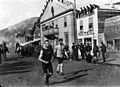
Foot race, Dawson City, about 1900
See also
 In Spanish: Dawson City para niños
