Tuktoyaktuk facts for kids
Quick facts for kids
Tuktoyaktuk
Tuktuyaaqtuuq
formerly Port Brabant
|
||
|---|---|---|
|
Hamlet
|
||
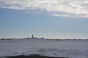
North Warning System radar station at Tuktoyaktuk
|
||
|
||
| Nickname(s):
Tuk
|
||
| Country | Canada | |
| Territory | Northwest Territories | |
| Region | Inuvik Region | |
| Electoral district | Nunakput | |
| Census division | Region 1 | |
| Settled | 1928 | |
| Incorporated | 1 April 1970 | |
| Area | ||
| • Land | 12.66 km2 (4.89 sq mi) | |
| Elevation | 5 m (15 ft) | |
| Population
(2021)
|
||
| • Total | 937 | |
| • Density | 74.0/km2 (192/sq mi) | |
| Time zone | UTC−07:00 (MST) | |
| • Summer (DST) | UTC−06:00 (MDT) | |
| Canadian Postal code |
X0E 1C0
|
|
| Area code(s) | 867 | |
| Telephone exchange | 977 | |
| – Living cost (2018) | 162.5 | |
| – Food price index (2019) | 157.8 | |
| Website | http://www.tuktoyaktuk.ca | |
| Sources: Department of Municipal and Community Affairs, Prince of Wales Northern Heritage Centre, Canada Flight Supplement Northwestel Natural Resources Canada 2018 figure based on Edmonton = 100 2019 figure based on Yellowknife = 100 |
||
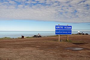
Tuktoyaktuk (pronounced "tuk-tuh-YAK-tuk"), also known as Tuktuyaaqtuuq, is a small community in Canada. Its name in the Inuvialuktun language means "it looks like a caribou." It's often called "Tuk" for short.
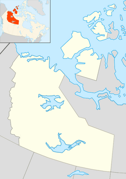
This Inuvialuit hamlet is located in the Northwest Territories. It sits near the Mackenzie River delta, which is where the Mackenzie River flows into the Arctic Ocean. Tuktoyaktuk is special because it's the only place on the Arctic Ocean that you can reach by road from the rest of Canada.
Before 1950, it was called Port Brabant. But in 1950, it became the first Indigenous community in Canada to get its traditional name back.
Contents
History of Tuktoyaktuk
The name Tuktoyaktuk comes from the Inuvialuit language. It means "resembling a caribou". A local story says that caribou once walked into the water and turned into stone. Today, you can see rock formations that look like these stone caribou along the shore when the tide is low.
For hundreds of years, the native Inuvialuit people used this area. It was a good place to hunt caribou and beluga whales. The natural harbour in Tuktoyaktuk was also important. It helped transport supplies to other Inuvialuit settlements.
Between 1890 and 1910, many families in Tuktoyaktuk were lost. This happened because of flu epidemics brought by American whalers. Later, people from the Dene group and Herschel Island moved here. By 1937, the Hudson's Bay Company had set up a trading post. In 1944, a strong windstorm hit the community. It damaged buildings and boats and caused the loss of 11 lives.
In the 1950s, Radar domes were built in Tuktoyaktuk. These were part of the Distant Early Warning Line. Their job was to watch for airplanes and detect any possible intrusions during the Cold War. Because of its location and harbour, Tuktoyaktuk was key for supplying workers along this defense line. In 1947, Tuktoyaktuk also became home to one of the first government day schools. These schools aimed to make Inuit youth adopt mainstream Canadian culture.
Later, Tuktoyaktuk became a base for finding oil and natural gas in the Beaufort Sea. Large industrial buildings still stand from this busy time. This period brought many new people to the region.
In 2014, work began on a new road. This road, called the Inuvik–Tuktoyaktuk Highway, connects Tuktoyaktuk to Inuvik. It was officially opened in November 2017. This highway provides year-round road access.
Geography and Natural Wonders
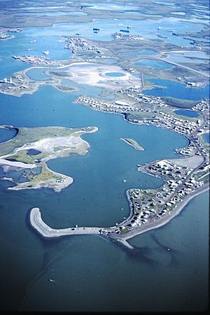
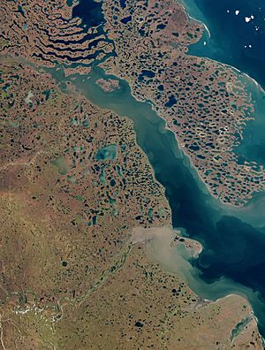
Tuktoyaktuk is located on Kugmallit Bay. This bay is close to the Mackenzie River Delta. The community is also right at the Arctic tree line, which is the northernmost point where trees can grow.
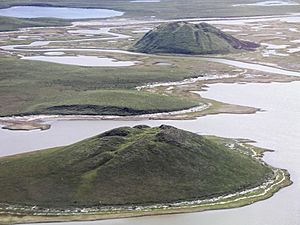
Tuktoyaktuk is a great place to start if you want to explore Pingo National Landmark. This area protects eight large, dome-shaped hills called pingos. Pingos are unique hills formed by ice pushing up the ground. This region has about 1,350 pingos in total. The landmark is about 16 square kilometers. It includes Canada's tallest pingo, which is 49 meters high. It's the second-highest pingo in the world!
How People Live and Work
Many people in Tuktoyaktuk still follow traditional ways of life. They hunt, fish, and trap for food. In the autumn, they rely on caribou. In spring and autumn, they hunt ducks and geese. Fishing is done all year round. Other activities include collecting driftwood and picking berries. Some people also work in reindeer herding.
Today, much of the work in Tuktoyaktuk comes from tourism and transportation. Marine Transportation Services (MTS) is a big employer. The oil and gas industry also provides jobs for explorers and other workers.
In 1962, a project called the Tuktoyaktuk Fur Garment Project began. It taught local women how to sew and make items like parkas, mitts, and slippers. These items were sold in a local shop, which closed in the 1980s.
Population and Languages
In the 2021 Census, Tuktoyaktuk had a population of 937 people. Most of the people living here are Indigenous (about 90.8%). The largest group is the Inuit (Inuvialuit), making up 88.0% of the population.
The main languages spoken in Tuktoyaktuk are Inuinnaqtun (which is a dialect of Inuvialuktun) and English. A few people also speak North Slavey and Tłı̨chǫ (Dogrib).
| Federal census population history of Tuktoyaktuk | ||
|---|---|---|
| Year | Pop. | ±% |
| 1971 | 597 | — |
| 1976 | 590 | −1.2% |
| 1981 | 772 | +30.8% |
| 1986 | 929 | +20.3% |
| 1991 | 918 | −1.2% |
| 1996 | 943 | +2.7% |
| 2001 | 930 | −1.4% |
| 2006 | 870 | −6.5% |
| 2011 | 854 | −1.8% |
| 2016 | 898 | +5.2% |
| 2021 | 937 | +4.3% |
| Source: Statistics Canada |
||
| Annual population estimates | |||||||||||||||||||||||||||||||||||||||||||||||||||||||||||||||||||||||||||||||
|---|---|---|---|---|---|---|---|---|---|---|---|---|---|---|---|---|---|---|---|---|---|---|---|---|---|---|---|---|---|---|---|---|---|---|---|---|---|---|---|---|---|---|---|---|---|---|---|---|---|---|---|---|---|---|---|---|---|---|---|---|---|---|---|---|---|---|---|---|---|---|---|---|---|---|---|---|---|---|---|
|
|
||||||||||||||||||||||||||||||||||||||||||||||||||||||||||||||||||||||||||||||
| Sources: NWT Bureau of Statistics (2008–2019), NWT Bureau of Statistics (2001–2017) | |||||||||||||||||||||||||||||||||||||||||||||||||||||||||||||||||||||||||||||||
| Panethnic group | 2021 | 2016 | 2011 | 2006 | 2001 | |||||
|---|---|---|---|---|---|---|---|---|---|---|
| Pop. | % | Pop. | % | Pop. | % | Pop. | % | Pop. | % | |
| Indigenous | 850 | 92.39% | 815 | 93.68% | 760 | 92.12% | 735 | 84.48% | 875 | 94.09% |
| European | 55 | 5.98% | 55 | 6.32% | 65 | 7.88% | 125 | 14.37% | 55 | 5.91% |
| Latin American | 10 | 1.09% | 0 | 0% | 0 | 0% | 0 | 0% | 0 | 0% |
| South Asian | 0 | 0% | 0 | 0% | 0 | 0% | 10 | 1.15% | 0 | 0% |
| African | 0 | 0% | 0 | 0% | 0 | 0% | 10 | 1.15% | 0 | 0% |
| East Asian | 0 | 0% | 0 | 0% | 0 | 0% | 0 | 0% | 0 | 0% |
| Southeast Asian | 0 | 0% | 0 | 0% | 0 | 0% | 0 | 0% | 0 | 0% |
| Middle Eastern | 0 | 0% | 0 | 0% | 0 | 0% | 0 | 0% | 0 | 0% |
| Other/multiracial | 0 | 0% | 0 | 0% | 0 | 0% | 0 | 0% | 0 | 0% |
| Total responses | 920 | 98.19% | 870 | 96.88% | 825 | 96.6% | 870 | 100% | 930 | 100% |
| Total population | 937 | 100% | 898 | 100% | 854 | 100% | 870 | 100% | 930 | 100% |
| Note: Totals greater than 100% due to multiple origin responses | ||||||||||
Climate and Weather
Tuktoyaktuk has a subarctic climate, which is very cold. It's almost a tundra climate. The average temperature in July is just above 10°C. The Arctic Ocean freezes for most of the year, which makes the winters very cold.
Even though it's cold, Tuktoyaktuk gets less rain and snow than many desert areas. However, because of the cold, it still gets over a meter of snow each year. Sometimes, warm air from the south can reach the region. This can cause surprisingly warm temperatures in the summer. For example, on July 4, 2022, Tuktoyaktuk reached 29.9°C. Its highest temperature ever recorded was 30.4°C on July 2, 1998.
| Climate data for Tuktoyaktuk (Tuktoyaktuk/James Gruben Airport) Climate ID: 2203912; coordinates 69°29′00″N 133°01′35″W / 69.48333°N 133.02639°W; elevation: 4.3 m (14 ft); 1991–2020 normals, extremes 1948–present |
|||||||||||||
|---|---|---|---|---|---|---|---|---|---|---|---|---|---|
| Month | Jan | Feb | Mar | Apr | May | Jun | Jul | Aug | Sep | Oct | Nov | Dec | Year |
| Record high humidex | 3.8 | 0.7 | 3.0 | 7.0 | 23.9 | 32.3 | 34.2 | 32.9 | 22.4 | 17.2 | 2.4 | 0.6 | 34.2 |
| Record high °C (°F) | 4.0 (39.2) |
0.7 (33.3) |
3.2 (37.8) |
8.3 (46.9) |
25.2 (77.4) |
29.4 (84.9) |
30.4 (86.7) |
29.9 (85.8) |
21.1 (70.0) |
17.9 (64.2) |
2.5 (36.5) |
0.8 (33.4) |
30.4 (86.7) |
| Mean daily maximum °C (°F) | −22.0 (−7.6) |
−22.1 (−7.8) |
−19.6 (−3.3) |
−9.8 (14.4) |
1.3 (34.3) |
11.6 (52.9) |
15.5 (59.9) |
12.5 (54.5) |
6.3 (43.3) |
−3.6 (25.5) |
−13.7 (7.3) |
−20.3 (−4.5) |
−5.3 (22.5) |
| Daily mean °C (°F) | −25.8 (−14.4) |
−26.0 (−14.8) |
−24.0 (−11.2) |
−14.6 (5.7) |
−2.5 (27.5) |
7.0 (44.6) |
11.4 (52.5) |
9.2 (48.6) |
3.6 (38.5) |
−6.3 (20.7) |
−17.1 (1.2) |
−23.8 (−10.8) |
−9.1 (15.6) |
| Mean daily minimum °C (°F) | −29.5 (−21.1) |
−29.8 (−21.6) |
−28.4 (−19.1) |
−19.3 (−2.7) |
−6.3 (20.7) |
2.4 (36.3) |
7.3 (45.1) |
5.9 (42.6) |
0.9 (33.6) |
−8.8 (16.2) |
−20.5 (−4.9) |
−27.2 (−17.0) |
−12.8 (9.0) |
| Record low °C (°F) | −48.9 (−56.0) |
−46.6 (−51.9) |
−45.5 (−49.9) |
−42.8 (−45.0) |
−28.9 (−20.0) |
−8.4 (16.9) |
−1.7 (28.9) |
−2.5 (27.5) |
−12.8 (9.0) |
−36.2 (−33.2) |
−40.1 (−40.2) |
−46.7 (−52.1) |
−48.9 (−56.0) |
| Record low wind chill | −70.8 | −61.2 | −58.1 | −55.5 | −40.1 | −16.5 | −6.5 | −8.9 | −21.6 | −43.5 | −50.8 | −58.9 | −70.8 |
| Average precipitation mm (inches) | 10.5 (0.41) |
8.9 (0.35) |
7.2 (0.28) |
8.3 (0.33) |
6.8 (0.27) |
11.0 (0.43) |
22.3 (0.88) |
25.7 (1.01) |
23.3 (0.92) |
18.4 (0.72) |
9.6 (0.38) |
8.7 (0.34) |
160.7 (6.33) |
| Average rainfall mm (inches) | 0.0 (0.0) |
0.0 (0.0) |
0.0 (0.0) |
0.0 (0.0) |
1.4 (0.06) |
9.7 (0.38) |
22.2 (0.87) |
24.4 (0.96) |
15.5 (0.61) |
1.3 (0.05) |
0.0 (0.0) |
0.3 (0.01) |
74.9 (2.95) |
| Average snowfall cm (inches) | 13.4 (5.3) |
10.2 (4.0) |
9.0 (3.5) |
9.4 (3.7) |
6.2 (2.4) |
1.3 (0.5) |
0.1 (0.0) |
1.2 (0.5) |
8.9 (3.5) |
20.1 (7.9) |
12.1 (4.8) |
11.2 (4.4) |
103.1 (40.6) |
| Average precipitation days (≥ 0.2 mm) | 8.4 | 7.3 | 7.1 | 5.5 | 4.9 | 5.1 | 10.1 | 12.7 | 12.7 | 13.3 | 9.6 | 8.9 | 105.6 |
| Average rainy days (≥ 0.2 mm) | 0.05 | 0.05 | 0.0 | 0.0 | 1.1 | 4.3 | 10.0 | 12.4 | 9.0 | 1.1 | 0.0 | 0.10 | 38.1 |
| Average snowy days (≥ 0.2 cm) | 8.6 | 7.4 | 7.5 | 5.8 | 4.2 | 1.0 | 0.14 | 0.90 | 5.0 | 13.0 | 9.9 | 9.1 | 72.5 |
| Average relative humidity (%) (at 1500 LST) | 78.4 | 78.4 | 75.7 | 77.5 | 77.2 | 69.3 | 69.7 | 75.4 | 79.0 | 86.7 | 85.0 | 80.6 | 76.7 |
| Source: Environment and Climate Change Canada (rain/rain days, snow/snow days and precipitation/precipitation days 1981–2010) | |||||||||||||
Getting Around Tuktoyaktuk
The Tuktoyaktuk/James Gruben Airport connects Tuktoyaktuk to Inuvik. This flight takes about 30 minutes. In the past, during winter, there was a special ice road called the Tuktoyaktuk Winter Road. It allowed cars to drive to Inuvik.
Now, the new Inuvik–Tuktoyaktuk Highway is open. It was completed in November 2017. This highway provides a way to drive to Inuvik all year round. From Inuvik, you can connect to the rest of Canada's road network.
 | Madam C. J. Walker |
 | Janet Emerson Bashen |
 | Annie Turnbo Malone |
 | Maggie L. Walker |


