
Pingo Canadian Landmark facts for kids
Quick facts for kids Pingo National Landmark |
|
|---|---|
|
IUCN Category VI (Managed Resource Protected Area)
|
|

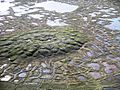
A melting pingo with wedge ice in Pingo National Landmark
|
|
| Lua error in Module:Location_map at line 420: attempt to index field 'wikibase' (a nil value). | |
| Location | Northwest Territories, Canada |
| Nearest city | Tuktoyaktuk, NT |
| Area | 16 km2 (6.2 sq mi) |
| Established | 25 July 1984 |
| Governing body | Parks Canada |
Pingo Canadian Landmark is a special natural area in the Northwest Territories of Canada. It protects eight amazing landforms called pingos near the town of Tuktoyaktuk. This coastal area near the Arctic Ocean has about 1,350 pingos. That's about one-quarter of all the pingos in the world!
Scientists have studied this area for over 50 years. Their research here helps us understand how pingos form and grow.
Contents
History of the Landmark
This special region was first recognized as important in 1978. It was suggested to make it a landmark. In 1984, a law was passed to create the Pingo Canadian Landmark. This law was part of an agreement with the Inuvialuit people.
The Landmark is managed together by the Government of Canada, the Inuvialuit Land Administration, and the people of Tuktoyaktuk. This means everyone works together to protect the pingos.
Even though a national landmarks program was planned, Pingo Canadian Landmark is still the only one of its kind in Canada.
Geography of the Pingos
The Landmark covers an area of about 16 km2 (6.2 sq mi). It is located just 5 km (3.1 mi) west of Tuktoyaktuk. The area includes Ibyuk Pingo, which is Canada's tallest pingo. It stands at 49 m (161 ft) high. Only Kadleroshilik Pingo in Alaska is taller.
The Landmark is in the Inuvialuit Settlement Region. Parks Canada manages it under the National Parks Act.
The land near the Beaufort Sea is quite flat. Because of this, pingos really stand out in the landscape. They rise from 5 to 36 m (16 to 118 ft) tall. You can see them at different stages of growth and even collapse. Ibyuk Pingo, the tallest, still grows about 2 cm (0.79 in) each year. Scientists think it is at least 1,000 years old.
Pingos are unique to areas with permafrost. They have formed here because there are many lakes on the Tuktoyaktuk Peninsula.
Geology and How Pingos Form

What are Pingos?
The Tuktoyaktuk Peninsula has the most pingos in the world. There are 1,350 of them! These pingos formed in two main ways:
- Hydrostatic pingos form in "closed systems." This happens in areas with continuous permafrost. Water gets trapped under an impermeable layer of ground. This causes pressure to build up, pushing the ground upwards into a pingo.
- Hydraulic pingos form in "open systems." Here, groundwater flows in from other areas. This water also creates pressure, leading to the formation of a pingo.
Other Cool Ice Features
The Landmark also protects amazing examples of massive ice. This is a large body of frozen groundwater. One part of an eroded hillside by the sea is over 500 m (1,600 ft) long and 10 m (33 ft) high. Other ice beds in the region are over 40 m (130 ft) thick. This ancient ice can be thousands of years old.
The permafrost environment also has wedge ice. These are vertical masses of ice. They form when water freezes in cracks in the ground. These cracks appear when the ground shrinks from extreme cold. When ice wedges connect, they can form cool patterns called tundra polygons. These polygons look most striking when you see them from above.
Ecology: Plants and Animals
Flora: Plants of the Pingo Landmark
About 1,200 different plant species can be found in the park. You might see shrubs like arctic willow, white heather, Labrador tea, and dwarf birch.
Several different berries grow here too. These include cranberries, cloudberries, and blueberries. Non-vascular plants like sphagnum moss and leaf lichen cover much of the ground. Because of the permafrost and short growing season, any trees you find are usually small and twisted. This is called krummholz form.
Fauna: Animals of the Pingo Landmark
Many animals live in this park. You might spot grizzly and polar bears. There are also wolf packs, two types of fox, and Arctic ground squirrels.
Many birds either nest or migrate around the park. These include brant geese, tundra swans, lesser snow geese, loons, and greater white-fronted geese. Ducks like mallard, green-winged teal, king eider, common eider, and oldsquaw are common. You can also see many types of gulls and shorebirds.
Visiting the Landmark
In August 2010, a boardwalk trail was finished. It has a boat launch, a dock, and viewing platforms. Parks Canada plans to add signs for self-guided tours.
Local tour operators can take you to the site. The easiest way to get there is by boat. Hiking is also an option, but it can be more challenging. No matter how you visit, Arctic weather and changing water levels can sometimes force you to change your plans.
In media
The Pingo Canadian Landmark was shown in Billy Connolly: Journey to the Edge of the World. This was a 2008 journey by the Scottish entertainer.
Images for kids
-
A melting pingo with wedge ice in Pingo National Landmark
-
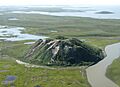
Ibyuk, the largest pingo in Canada and the second largest in the world after Kadleroshilik Pingo in Alaska
See also
 In Spanish: Hito nacional Pingo para niños
