Inuvialuit Settlement Region facts for kids
Quick facts for kids
Inuvialuit Settlement Region
Inuvialuit Nunangit Sannaiqtuaq
|
|
|---|---|
|
Region
|
|

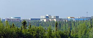
Inuvik, the largest community in the region
|
|
|
ISR in Yukon and NWT
|
|
| Country | Canada |
| Territories | Northwest Territories Yukon |
| Inuvialuit Final Agreement | 1984 |
| Subregions |
List
Beaufort Sea
Mackenzie River delta Yukon coast Northwest portion of Northwest Territories Western Arctic Archipelago |
| Government | |
| • Type | Board of Directors |
| Area | |
| • Total | 435,000 km2 (168,000 sq mi) |
| • Land | 90,650 km2 (35,000 sq mi) |
| Lowest elevation | 0 m (0 ft) |
| Population
(2006)
|
|
| • Total | 5,336 |
| • Density | 0.012267/km2 (0.03177/sq mi) |
| Languages | |
| • Indigenous | Inuvialuktun Siglitun Uummarmiutun Inuinnaqtun Inuit Uukturausingit (?) |
| • Settler | English |
| Time zone | UTC−07:00 (MST) |
| • Summer (DST) | UTC−06:00 (MDT) |
| Website | Inuvialuit Regional Corporation |
| The Northwest Territories area of the ISR is on MST but Herschel Island, Yukon is on PST (UTC−08:00) and PDT (UTC−07:00) | |
| Inu- ᐃᓄ- / nuna ᓄᓇ "person" / "land" |
|
|---|---|
| Person | Inuvialuk |
| People | Inuvialuit |
| Language | Inuvialuktun; Uukturausingit |
| Country | Inuvialuit Nunangit, Inuit Nunangat ᐃᓄᐃᑦ ᓄᓇᖓᑦ |
The Inuvialuit Settlement Region (ISR) is a special area in Canada's western Arctic. It was created in 1984 through an agreement between the Government of Canada and the Inuvialuit people. This agreement is called the Inuvialuit Final Agreement.
The ISR covers a huge area of land, about 90,650 square kilometers. Most of this land is above the tree line, meaning it's too cold for trees to grow tall. The region includes parts of the Beaufort Sea, the Mackenzie River delta, the northern Yukon coast, and the northwest Northwest Territories. It has both government-owned land (Crown Lands) and private lands belonging to the Inuvialuit.
The ISR is one of four Inuit regions in Canada. These regions together are known as Inuit Nunangat. The Inuvialuit Settlement Region is the traditional home of the Inuvialuit people. The Inuvialuit Regional Corporation helps manage the land and money from the agreement. This corporation is run by the Inuvialuit people themselves.
Contents
Inuvialuit Communities and Culture

In 2016, about 5,336 people lived in the ISR. More than half of them (3,110 people) were Inuvialuit. The Inuvialuit form the main population in all six communities within the region. There are no towns or villages on the Yukon North Slope part of the ISR.
All six communities in the ISR are in the Northwest Territories. They are part of the Inuvik Region, which also includes Fort McPherson and Tsiigehtchic.
Inuvik is the biggest town and the main center for the region. It's located on the Mackenzie Delta, about 100 kilometers from the Arctic Ocean. The Inuvialuit Regional Corporation has its main office here. Aklavik is the only other community not directly on the coast.
Many people in Paulatuk and Sachs Harbour still hunt, fish, and trap for a living. Sachs Harbour is the only permanent town on Banks Island. Tuktoyaktuk has the only deepwater port in the ISR, which is important for shipping. Ulukhaktok is on Victoria Island. In recent years, making prints and art has become a major way for people there to earn money. Herschel Island is part of the ISR but is in Yukon. It's not inhabited now but was traditionally used by the Inuvialuit.
English is spoken throughout the region. However, many Inuvialuit also speak their traditional languages. Siglitun is spoken in Paulatuk, Sachs Harbour, and Tuktoyaktuk. Uummarmiutun is used in Inuvik and Aklavik. Inuinnaqtun is spoken in Ulukhaktok. These languages are all part of the larger Inuvialuktun language group.
Arctic Climate
The Inuvialuit Settlement Region has a cold Arctic climate. Here's a look at the average daily temperatures in some of the towns:
| Town | Jan | Feb | Mar | Apr | May | Jun | Jul | Aug | Sep | Oct | Nov | Dec | Year |
|---|---|---|---|---|---|---|---|---|---|---|---|---|---|
| Aklavik | −26.3 °C (−15.3 °F) | −25.7 °C (−14.3 °F) | −21.7 °C (−7.1 °F) | −12.5 °C (9.5 °F) | −0.1 °C (31.8 °F) | 11.4 °C (52.5 °F) | 13.9 °C (57.0 °F) | 10.9 °C (51.6 °F) | 4.4 °C (39.9 °F) | −7.6 °C (18.3 °F) | −20.7 °C (−5.3 °F) | −24.7 °C (−12.5 °F) | −8.2 °C (17.2 °F) |
| Inuvik | −26.9 °C (−16.4 °F) | −25.5 °C (−13.9 °F) | −22.3 °C (−8.1 °F) | −11.8 °C (10.8 °F) | 0.4 °C (32.7 °F) | 11.6 °C (52.9 °F) | 14.1 °C (57.4 °F) | 11.0 °C (51.8 °F) | 3.9 °C (39.0 °F) | −7.6 °C (18.3 °F) | −21.1 °C (−6.0 °F) | −24.1 °C (−11.4 °F) | −8.2 °C (17.2 °F) |
| Paulatuk | −25.6 °C (−14.1 °F) | −26.2 °C (−15.2 °F) | −23.5 °C (−10.3 °F) | −14.3 °C (6.3 °F) | −3.9 °C (25.0 °F) | 5.9 °C (42.6 °F) | 10.1 °C (50.2 °F) | 8.7 °C (47.7 °F) | 3.3 °C (37.9 °F) | −6.0 °C (21.2 °F) | −17.9 °C (−0.2 °F) | −22.0 °C (−7.6 °F) | −9.3 °C (15.3 °F) |
| Sachs Harbour | −28.0 °C (−18.4 °F) | −28.3 °C (−18.9 °F) | −26.7 °C (−16.1 °F) | −18.3 °C (−0.9 °F) | −7.6 °C (18.3 °F) | 3.1 °C (37.6 °F) | 6.6 °C (43.9 °F) | 3.7 °C (38.7 °F) | −1.2 °C (29.8 °F) | −10.7 °C (12.7 °F) | −20.5 °C (−4.9 °F) | −25.1 °C (−13.2 °F) | −12.8 °C (9.0 °F) |
| Tuktoyaktuk | −26.6 °C (−15.9 °F) | −26.4 °C (−15.5 °F) | −25.1 °C (−13.2 °F) | −15.7 °C (3.7 °F) | −4.7 °C (23.5 °F) | 6.4 °C (43.5 °F) | 11.0 °C (51.8 °F) | 8.9 °C (48.0 °F) | 3.3 °C (37.9 °F) | −7.4 °C (18.7 °F) | −20.7 °C (−5.3 °F) | −23.8 °C (−10.8 °F) | −10.1 °C (13.8 °F) |
| Ulukhaktok | −28.0 °C (−18.4 °F) | −28.8 °C (−19.8 °F) | −25.6 °C (−14.1 °F) | −17.0 °C (1.4 °F) | −6.6 °C (20.1 °F) | 4.6 °C (40.3 °F) | 9.0 °C (48.2 °F) | 6.4 °C (43.5 °F) | 0.9 °C (33.6 °F) | −8.9 °C (16.0 °F) | −19.8 °C (−3.6 °F) | −25.2 °C (−13.4 °F) | −11.6 °C (11.1 °F) |
Wildlife and Natural Resources
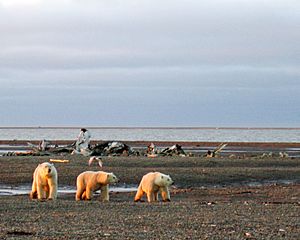
The ISR is home to many amazing Arctic animals. The Inuvialuit have a plan to manage and protect these fish and wildlife. This plan helps make sure animals like Arctic char, Arctic fox, beluga whale, bearded seal, bowhead whale, caribou, moose, muskox, polar bear, ringed seal, and whitefish stay healthy.
The region also has important natural resources hidden underground. These include natural gas, nickel, petroleum (oil), and zinc. Some Inuvialuit lands mean the people own both the surface and the minerals below. On other lands, they only own the surface.
Protected Areas
To protect the environment and wildlife, the ISR has several special parks and bird sanctuaries.
- National Parks:
- Aulavik National Park
- Ivvavik National Park
- Tuktut Nogait National Park
- Territorial Park:
- Herschel Island Territorial Park
- Landmark:
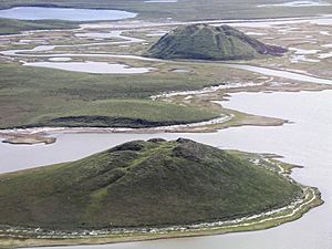
- Pingo Canadian Landmark (a pingo is a hill of ice covered by earth)
- Bird Sanctuaries:
- Anderson River Delta Migratory Bird Sanctuary
- Banks Island No. 1 Bird Sanctuary
- Cape Perry Migratory Bird Sanctuary
- Kendall Island Migratory Bird Sanctuary
 | John T. Biggers |
 | Thomas Blackshear |
 | Mark Bradford |
 | Beverly Buchanan |


