Anderson River (Northwest Territories) facts for kids
Quick facts for kids Anderson River |
|
|---|---|
|
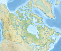
Location of the Anderson River in Canada
|
|
| Native name | Kuuk |
| Other name(s) | Beghula |
| Country | Canada |
| Territory | Northwest Territories |
| Physical characteristics | |
| Main source | Colville Lake Sahtu Region 244 m (801 ft) 67°18′N 125°43′W / 67.300°N 125.717°W |
| River mouth | Arctic Ocean Beaufort Sea, Inuvik Region 0 m (0 ft) 69°43′N 129°00′W / 69.717°N 129.000°W |
| Length | 692 km (430 mi) |
| Basin features | |
| Tributaries |
|
| River source, names | |
The Anderson River is a cool river in the Northwest Territories of northern Canada. Its name in Inuvialuktun, a local language, is Kuuk, which means 'river'. It starts in lakes northwest of Great Bear Lake, possibly near Colville Lake. The river flows north and west, between the Mackenzie and Coppermine Rivers. It empties into the Beaufort Sea, which is part of the Arctic Ocean. The main river that flows into the Anderson River is the Carnwath River.
The river was first known as the Beghula River. In 1857, it was renamed the Anderson River by Roderick MacFarlane. He named it after James Anderson, who was an important leader for the Hudson's Bay Company in the Mackenzie area.
Contents
Exploring the Anderson River's Landscape
The Anderson River flows through different types of land. It is part of the Anderson Plain, which is a high subarctic area. It also goes through the Anderson Upland, a low arctic region.
River Features and Scenery
The river's path includes many canyons, especially in its upper and middle parts. The biggest canyon is Falcon Canyon. It is about 6 kilometers (3.7 miles) long and 40 meters (130 feet) deep.
In the upper parts of the river, you'll find a taiga forest. Here, black spruce trees are very common. White spruce and shrublands grow along the river's edges. The area has old rock layers, like shale and limestone.
Closer to the ocean, the river goes above the tree line. This means there are no more tall trees. Instead, the landscape changes to rolling tundra, which is a flat, treeless plain. This area is east of Inuvik.
Paddling the River
The middle part of the river has the most exciting whitewater sections. Around Falcon Canyon and upstream, there are some Class III rapids. There are also many Class I and II rapids. This makes the Anderson River a fun trip for experienced paddlers. It's exciting but not too difficult.
Amazing Wildlife Along the River
The Anderson River is home to many different animals. It's a great place to see wildlife.
Land Animals You Might Spot
The Bluenose barren-ground caribou herd travels through parts of the Anderson River valley in July. These caribou give birth further east near Bluenose Lake. You might also see muskox, moose, and grizzly bears along the river.
Bird Life and Important Areas
Many kinds of birds live here too. However, studies have shown that the number of snow geese in the area has gone down.
The last 50 kilometers (31 miles) of the river are very important for birds. This area is called an Important Bird Area. It covers about 759 square kilometers (293 square miles). There's an even bigger area called the Anderson River Delta Migratory Bird Sanctuary. This sanctuary protects birds and covers about 1,184 square kilometers (457 square miles).
Ocean Animals Near the Delta
Where the river meets the Arctic Ocean, you might see ringed seals and bearded seals. In the ocean itself, groups of beluga whales are often seen swimming.
A Look Back: History of the Anderson River Area
The Anderson River area was once the home of an Inuvialuit group of Inuit people. They were known as the Siglit, or Mackenzie Inuit. People called them the Anderson River People. Their old Inuvialuktun name might have been Kuukugmiut or Kuungmiut. These names mean "people of the river," from the word Kuuk (river).
Early Trading and Exploration
In 1857, Roderick MacFarlane from the Hudson's Bay Company explored this area. He wanted to trade with the Inuit. The Inuit didn't want to travel to the trading post at Fort McPherson. This was because of fights with the Gwich'in people and the long journey. MacFarlane first met some unfriendly Inuit and went back to Fort Good Hope.
He tried again in 1858 and 1859. This time, he had no problems and started trading with the Inuit. In 1860, he was sent back to build a permanent trading post. Construction began in the spring of 1861 and was finished before winter. The post was on the east bank of the river. It was about 183 kilometers (114 miles) south of Liverpool Bay. It was also about 50 kilometers (31 miles) north of the Anderson River Forks.
Collecting for Science
While at the post, MacFarlane met Robert Kennicott. Kennicott encouraged him to collect items for the Smithsonian Institution. MacFarlane collected over 5,000 objects. These included a special type of bear, now called MacFarlane's bear. These items are now part of the MacFarlane Collection.
The Trading Post Closes
The trading post was successful until 1864–65. In 1864, many sled dogs died from a sickness called distemper. Then, in 1865, a mix of scarlet fever and measles caused many Inuit and First Nations hunters in the area to die. MacFarlane stayed at the fort until July 15, 1866. After that, the post was closed, and he moved to Fort Simpson.
Other Posts and Stations
The Hudson's Bay Company also had another trading post at the river's mouth. This post was later named Stanton. It is now abandoned. Sometime after 1925, a reindeer substation was opened. It was called Anderson River and was about 16 kilometers (10 miles) south of Stanton.
 | John T. Biggers |
 | Thomas Blackshear |
 | Mark Bradford |
 | Beverly Buchanan |


