kids encyclopedia robot

Arctic Archipelago facts for kids

Kids Encyclopedia Facts
Quick facts for kids
Arctic Archipelago
Archipel Arctique Canadien  (French)
Arcticisl.png
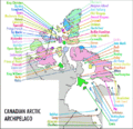
Polar projection map of the Arctic Archipelago
Canadian Arctic Archipelago.svg
Geography
Location Northern Canada
Coordinates 75°N 90°W / 75°N 90°W / 75; -90 (Arctic Archipelago)
Total islands 36,563
Major islands Baffin Island, Victoria Island, Ellesmere Island
Area 1,407,770 km2 (543,540 sq mi)
Administration
Canada
Territories and province Nunavut
Northwest Territories
Yukon
Newfoundland and Labrador
Largest settlement Iqaluit, Nunavut (pop. 7,429)
Demographics
Population 23,073 (2021)
Pop. density 0.0098 /km2 (0.0254 /sq mi)

The Arctic Archipelago, also known as the Canadian Arctic Archipelago, is an archipelago lying to the north of the Canadian continental mainland, excluding Greenland (an autonomous territory of Denmark) and Iceland (an independent country).

Situated in the northern extremity of North America and covering about 1,424,500 km2 (550,000 sq mi), this group of 36,563 islands, surrounded by the Arctic Ocean, comprises much of Northern Canada, predominately Nunavut and the Northwest Territories. The archipelago is showing some effects of climate change, with some computer estimates determining that melting there will contribute 3.5 cm (1.4 in) to the rise in sea levels by 2100.

History

Around 2500 BCE, the first humans, the Paleo-Eskimos, arrived in the archipelago from the Canadian mainland. Between 1000–1500 CE, they were replaced by the Thule people, who are the ancestors of today's Inuit.

British claims on the islands, the British Arctic Territories, were based on the explorations in the 1570s by Martin Frobisher. Canadian sovereignty was originally (1870–80) only over island portions that drained into Foxe Basin, Hudson Bay and Hudson Strait. Canadian sovereignty over the islands was established by 1880 when Britain transferred them to Canada. The District of Franklin – established in 1895 – comprised almost all of the archipelago. The district was dissolved upon the creation of Nunavut in 1999. Canada claims all the waterways of the Northwest Passage as Canadian Internal Waters; however, the United States and most other maritime countries view these as international waters. Disagreement over the passages' status has raised Canadian concerns about environmental enforcement, national security, and general sovereignty. East of Ellesmere Island, in the Nares Strait, lies Hans Island, ownership of which is now shared between Canada and Denmark, after a decades-long dispute.

Geography

Wfm baffin island
Satellite image of Baffin Island, the largest island by total area of the Arctic Archipelago

The archipelago extends some 2,400 km (1,500 mi) longitudinally and 1,900 km (1,200 mi) from the mainland to Cape Columbia, the northernmost point on Ellesmere Island. It is bounded on the west by the Beaufort Sea; on the northwest by the Arctic Ocean; on the east by Greenland, Baffin Bay and Davis Strait; and on the south by Hudson Bay and the Canadian mainland. The various islands are separated from each other and the continental mainland by a series of waterways collectively known as the Northwest Passage. Two large peninsulas, Boothia and Melville, extend northward from the mainland. The northernmost cluster of islands, including Ellesmere Island, is known as the Queen Elizabeth Islands and was formerly the Parry Islands.

The archipelago consists of 36,563 islands, of which 94 are classified as major islands, being larger than 130 km2 (50 sq mi), and cover a total area of 1,400,000 km2 (540,000 sq mi). The islands of the archipelago over 10,000 km2 (3,900 sq mi), in order of descending area, are:

Name Location* Area Area rank Population
(2021)
World Canada
Baffin Island NU 507,451 km2 (195,928 sq mi) 5 1 13,039
Victoria Island NT, NU 217,291 km2 (83,897 sq mi) 8 2 2,168
Ellesmere Island NU 196,236 km2 (75,767 sq mi) 10 3 144
Banks Island NT 70,028 km2 (27,038 sq mi) 24 5 104
Devon Island NU 55,247 km2 (21,331 sq mi) 27 6 0
Axel Heiberg Island NU 43,178 km2 (16,671 sq mi) 32 7 0
Melville Island NT, NU 42,149 km2 (16,274 sq mi) 33 8 0
Southampton Island NU 41,214 km2 (15,913 sq mi) 34 9 1,038
Prince of Wales Island NU 33,339 km2 (12,872 sq mi) 40 10 0
Somerset Island NU 24,786 km2 (9,570 sq mi) 46 12 0
Bathurst Island NU 16,042 km2 (6,194 sq mi) 54 13 0
Prince Patrick Island NT 15,848 km2 (6,119 sq mi) 55 14 0
King William Island NU 13,111 km2 (5,062 sq mi) 61 15 1,349
Ellef Ringnes Island NU 11,295 km2 (4,361 sq mi) 69 16 0
Bylot Island NU 11,067 km2 (4,273 sq mi) 72 17 0

* NT = Northwest Territories, NU = Nunavut

After Greenland, the archipelago is the world's largest high-Arctic land area. The climate of the islands is Arctic, and the terrain consists of tundra except in mountainous regions. Most of the islands are uninhabited; human settlement is extremely thin and scattered, being mainly coastal Inuit settlements on the southern islands.

Map with links to islands

Reference map of Canadian Arctic Archipelago


Islands not on map


Communities

Community Island Region, territory Population
Arctic Bay Baffin Island Qikiqtaaluk, NU 944
Clyde River Baffin Island Qikiqtaaluk, NU 1,181
Iqaluit Baffin Island Qikiqtaaluk, NU 7,429
Kimmirut Baffin Island Qikiqtaaluk, NU 426
Pangnirtung Baffin Island Qikiqtaaluk, NU 1,504
Pond Inlet Baffin Island Qikiqtaaluk, NU 1,555
Sachs Harbour Banks Island Inuvik, NT 104
Qikiqtarjuaq Broughton Island Qikiqtaaluk, NU 593
Resolute Cornwallis Island Qikiqtaaluk, NU 183
Kinngait Dorset Island Qikiqtaaluk, NU 1,396
Grise Fiord Ellesmere Island Qikiqtaaluk, NU 144
Sanikiluaq Flaherty Island Qikiqtaaluk, NU 1,010
Igloolik Igloolik Island Qikiqtaaluk, NU 2,049
Gjoa Haven King William Island Kitikmeot, NU 1,349
Coral Harbour Southampton Island Kivalliq, NU 1,038
Cambridge Bay Victoria Island Kitikmeot, NU 1,760
Ulukhaktok Victoria Island Inuvik, NT 408
Total 23,073

Populated islands

Of the more than 36,000 islands, only 11 are populated. Baffin Island, the largest, also has the largest population of 13,309. The population accounts for 67.37 per cent of the 19,355 people in the Qikiqtaaluk Region, 56.51 per cent of the population of the Arctic Archipelago, and 35.38 per cent of the population of Nunavut.

Island Population Area
(km2)
Area
(sq mi)
Density
(km2)
Density
(sq mi)
Baffin Island 13,039 507,451 315,315 0.026 0.067
Banks Island 104 70,028 43,513 0.001 0.0026
Broughton Island 593 127.6 79.3 4.647 12.04
Cornwallis Island 183 6,995 4,346 0.026 0.067
Dorset Island 1,396 21 8 174.500 67.375
Ellesmere Island 144 196,236 121,935 0.001 0.0026
Flaherty Island 1,010 1,585 985 0.637 1.65
Igloolik Island 2,049 114.5 71.1 17.895 46.35
King William Island 1,349 13,111 8,147 0.103 0.27
Southampton Island 1,038 41,214 25,609 0.103 0.27
Victoria Island 2,168 217,291 135,018 0.010 0.026

Mapping

  • King Christian Island, 77°45′N 102°00′W / 77.750°N 102.000°W / 77.750; -102.000 (King Christian Island, NU)
  • Borden Island, 78°33′N 111°10′W / 78.550°N 111.167°W / 78.550; -111.167 (Borden Island, NT, NU)
  • Lougheed Island, 77°24′N 105°15′W / 77.400°N 105.250°W / 77.400; -105.250 (Lougheed Island, NT)
  • Brock Island, 77°51′N 114°27′W / 77.850°N 114.450°W / 77.850; -114.450 (Brock Island, NT)
  • Mackenzie King Island, 77°43′N 111°57′W / 77.717°N 111.950°W / 77.717; -111.950 (Mackenzie King Island, NT, NU)
  • Helena Island, 76°40′N 101°00′W / 76.667°N 101.000°W / 76.667; -101.000 (Helena Island, NU)
  • Cameron Island, 77°48′N 101°51′W / 77.800°N 101.850°W / 77.800; -101.850 (Cameron Island, NU)
  • Emerald Isle, 76°48′N 114°07′W / 76.800°N 114.117°W / 76.800; -114.117 (Emerald Isle, NT)
  • Prince Patrick Island, 76°45′N 119°30′W / 76.750°N 119.500°W / 76.750; -119.500 (Prince Patrick Island, NT)
  • Île Vanier, 76°10′N 103°15′W / 76.167°N 103.250°W / 76.167; -103.250 (Île Vanier, NU)
  • Eglinton Island, 75°46′N 118°27′W / 75.767°N 118.450°W / 75.767; -118.450 (Eglinton Island, NT)
  • Alexander Island, 75°52′N 102°37′W / 75.867°N 102.617°W / 75.867; -102.617 (Alexander Island, NU)
  • Bathurst Island, 75°46′N 099°47′W / 75.767°N 99.783°W / 75.767; -99.783 (Bathurst Island, NU)
  • Melville Island, 75°30′N 111°30′W / 75.500°N 111.500°W / 75.500; -111.500 (Melville Island, NT, NU)
  • Byam Martin Island, 75°12′N 104°17′W / 75.200°N 104.283°W / 75.200; -104.283 (Byam Martin Island, NU)
  • Banks Island, 73°00′N 121°30′W / 73.000°N 121.500°W / 73.000; -121.500 (Banks Island, NU)
  • Stefansson Island, 73°30′N 105°30′W / 73.500°N 105.500°W / 73.500; -105.500 (Stefansson Island, NU)
  • Russell Island, 74°00′N 098°25′W / 74.000°N 98.417°W / 74.000; -98.417 (Russell Island, NU)
  • Prince of Wales Island, 72°36′N 098°32′W / 72.600°N 98.533°W / 72.600; -98.533 (Prince of Wales Island, NU)
  • Prescott Island, 73°03′N 096°49′W / 73.050°N 96.817°W / 73.050; -96.817 (Prescott Island, NU)
  • Somerset Island, 73°15′N 093°30′W / 73.250°N 93.500°W / 73.250; -93.500 (Somerset Island, NU)
  • Victoria Island, 71°00′N 110°00′W / 71.000°N 110.000°W / 71.000; -110.000 (Victoria Island, NT, NU)
  • King William Island, 68°58′N 097°14′W / 68.967°N 97.233°W / 68.967; -97.233 (King William Island, NU)
  • Matty Island, 69°28′N 095°40′W / 69.467°N 95.667°W / 69.467; -95.667 (Matty Island, NU)
  • Wales Island, 68°01′N 086°40′W / 68.017°N 86.667°W / 68.017; -86.667 (Wales Island, NU)
  • Belcher Islands, 56°20′N 079°30′W / 56.333°N 79.500°W / 56.333; -79.500 (Belcher Islands, NU)
  • Long Island, 54°52′N 079°25′W / 54.867°N 79.417°W / 54.867; -79.417 (Long Island, NU)
  • Akimiski Island, 53°00′N 081°20′W / 53.000°N 81.333°W / 53.000; -81.333 (Akimiski Island, NU)
  • Charlton Island, 52°00′N 079°26′W / 52.000°N 79.433°W / 52.000; -79.433 (Charlton Island, NU)
  • Ellesmere Island, 79°49′N 078°00′W / 79.817°N 78.000°W / 79.817; -78.000 (Ellesmere Island, NU)
  • Meighen Island, 79°59′N 099°30′W / 79.983°N 99.500°W / 79.983; -99.500 (Meighen Island, NU)
  • Axel Heiberg Island, 79°26′N 090°46′W / 79.433°N 90.767°W / 79.433; -90.767 (Axel Heiberg Island, NU)
  • Ellef Ringnes Island, 78°37′N 101°56′W / 78.617°N 101.933°W / 78.617; -101.933 (Ellef Ringnes Island, NU)
  • Amund Ringnes Island, 78°19′N 096°25′W / 78.317°N 96.417°W / 78.317; -96.417 (Amund Ringnes Island, NU)
  • Cornwall Island, 77°37′N 094°52′W / 77.617°N 94.867°W / 77.617; -94.867 (Cornwall Island, NU)
  • Graham Island, 77°26′N 090°30′W / 77.433°N 90.500°W / 77.433; -90.500 (Graham Island, NU)
  • North Kent Island, 76°40′N 090°15′W / 76.667°N 90.250°W / 76.667; -90.250 (North Kent Island, NU)
  • Baillie-Hamilton Island, 75°53′N 094°35′W / 75.883°N 94.583°W / 75.883; -94.583 (Baillie-Hamilton Island, NU)
  • Little Cornwallis Island, 75°30′N 096°30′W / 75.500°N 96.500°W / 75.500; -96.500 (Little Cornwallis Island, NU)
  • Cornwallis Island, 75°05′N 095°00′W / 75.083°N 95.000°W / 75.083; -95.000 (Cornwallis Island, NU)
  • Devon Island, 75°15′N 088°00′W / 75.250°N 88.000°W / 75.250; -88.000 (Devon Island, NU)
  • Bylot Island, 73°13′N 078°34′W / 73.217°N 78.567°W / 73.217; -78.567 (Bylot Island, NU)
  • Baffin Island, 69°00′N 072°00′W / 69.000°N 72.000°W / 69.000; -72.000 (Baffin Island, NU)
  • Jens Munk Island, 69°40′N 079°40′W / 69.667°N 79.667°W / 69.667; -79.667 (Jens Munk Island, NU)
  • Koch Island, 69°35′N 078°20′W / 69.583°N 78.333°W / 69.583; -78.333 (Koch Island, NU)
  • Bray Island, 69°20′N 077°00′W / 69.333°N 77.000°W / 69.333; -77.000 (Bray Island, NU)
  • Rowley Island, 69°05′N 078°52′W / 69.083°N 78.867°W / 69.083; -78.867 (Rowley Island, NU)
  • Foley Island, 68°30′N 075°00′W / 68.500°N 75.000°W / 68.500; -75.000 (Foley Island, NU)
  • Air Force Island, 67°58′N 074°05′W / 67.967°N 74.083°W / 67.967; -74.083 (Air Force Island, NU)
  • Prince Charles Island, 67°45′N 076°00′W / 67.750°N 76.000°W / 67.750; -76.000 (Prince Charles Island, NU)
  • Vansittart Island, 65°50′N 084°00′W / 65.833°N 84.000°W / 65.833; -84.000 (Vansittart Island, NU)
  • White Island, 65°46′N 084°53′W / 65.767°N 84.883°W / 65.767; -84.883 (White Island, NU)
  • Southampton Island, 64°30′N 084°30′W / 64.500°N 84.500°W / 64.500; -84.500 (Southampton Island, NU)
  • Resolution Island, 61°35′N 065°00′W / 61.583°N 65.000°W / 61.583; -65.000 (Resolution Island, NU)
  • Loks Land Island, 62°26′N 064°38′W / 62.433°N 64.633°W / 62.433; -64.633 (Loks Land Island, NU)
  • Akpatok Island, 60°25′N 068°08′W / 60.417°N 68.133°W / 60.417; -68.133 (Akpatok Island, NU)
  • Big Island, 62°43′N 070°43′W / 62.717°N 70.717°W / 62.717; -70.717 (Big Island, NU)
  • Salisbury Island, 63°35′N 077°00′W / 63.583°N 77.000°W / 63.583; -77.000 (Salisbury Island, NU)
  • Nottingham Island, 63°17′N 077°55′W / 63.283°N 77.917°W / 63.283; -77.917 (Nottingham Island, NU)
  • Mansel Island, 62°00′N 079°50′W / 62.000°N 79.833°W / 62.000; -79.833 (Mansel Island, NU)
  • Coats Island, 62°35′N 082°45′W / 62.583°N 82.750°W / 62.583; -82.750 (Coats Island, NU)
  • Beechey Island, 74°43′N 091°51′W / 74.717°N 91.850°W / 74.717; -91.850 (Beechey Island, NU)
  • Broughton Island, 67°34′N 063°54′W / 67.567°N 63.900°W / 67.567; -63.900 (Broughton Island, NU)
  • Dorset Island, 64°12′N 76°32′W / 64.200°N 76.533°W / 64.200; -76.533 (Dorset Island, NU)
  • Duke of York Archipelago, 68°15′N 112°30′W / 68.250°N 112.500°W / 68.250; -112.500 (Duke of York Archipelago, NU)
  • East Pen Island, 56°45′N 088°40′W / 56.750°N 88.667°W / 56.750; -88.667 (East Pen Island, NU)
  • Flaherty Island, 56°14′N 079°17′W / 56.233°N 79.283°W / 56.233; -79.283 (Flaherty Island, NU)
  • Haig-Thomas Island, 78°15′N 094°30′W / 78.250°N 94.500°W / 78.250; -94.500 (Haig-Thomas Island, NU)
  • Hans Island, 80°49′N 066°27′W / 80.817°N 66.450°W / 80.817; -66.450 (Hans Island, Canada, Denmark)
  • Herschel Island, 69°35′N 139°04′W / 69.583°N 139.067°W / 69.583; -139.067 (Herschel Island)
  • Igloolik Island, 69°23′N 081°40′W / 69.383°N 81.667°W / 69.383; -81.667 (Igloolik Island, NU)
  • Killiniq Island, 60°22′N 064°37′W / 60.367°N 64.617°W / 60.367; -64.617 (Killiniq Island, NU)
  • Ottawa Islands, 59°34′N 080°16′W / 59.567°N 80.267°W / 59.567; -80.267 (Ottawa Islands, NU)
  • Prince Leopold Island, 74°01′N 090°04′W / 74.017°N 90.067°W / 74.017; -90.067 (Prince Leopold Island, NU)
  • Jenny Lind Island, 68°43′N 101°58′W / 68.717°N 101.967°W / 68.717; -101.967 (Jenny Lind Island, NU)
  • Skraeling Island, 78°55′N 075°40′W / 78.917°N 75.667°W / 78.917; -75.667 (Skraeling Island, NU)
  • Trodely Island, 52°14′N 079°26′W / 52.233°N 79.433°W / 52.233; -79.433 (Trodely Island, NU)
  • Gateshead Island, 70°35′N 100°25′W / 70.583°N 100.417°W / 70.583; -100.417 (Gateshead Island, NU)
  • Weston Island, 52°32′N 079°35′W / 52.533°N 79.583°W / 52.533; -79.583 (Weston Island, NU)

See also

Kids robot.svg In Spanish: Archipiélago Ártico Canadiense para niños

kids search engine
Arctic Archipelago Facts for Kids. Kiddle Encyclopedia.