Prince Patrick Island facts for kids
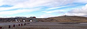
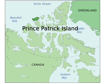
Prince Patrick Island, showing the Mould Bay weather station
|
|
 |
|
| Geography | |
|---|---|
| Location | Northern Canada |
| Coordinates | 76°45′N 119°30′W / 76.750°N 119.500°W |
| Archipelago | Queen Elizabeth Islands Arctic Archipelago |
| Area | 15,848 km2 (6,119 sq mi) |
| Area rank | 55th |
| Highest elevation | 279 m (915 ft) |
| Highest point | unnamed |
| Administration | |
|
Canada
|
|
| Territory | Northwest Territories |
| Demographics | |
| Population | Uninhabited |
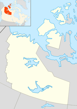
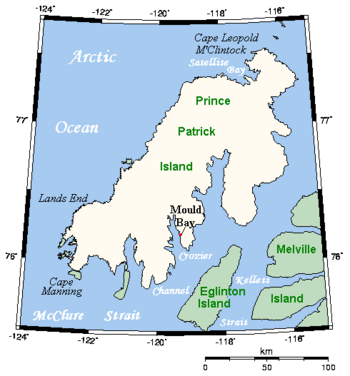
Prince Patrick Island is a large, lonely island in the far north of Canada. It is the westernmost island in the Queen Elizabeth Islands and part of the Arctic Archipelago. This island is located in the Northwest Territories.
The island covers about 15,848 square kilometers (6,119 square miles). This makes it the 55th largest island in the world and Canada's 14th largest island. For most of the year, the waters around the island are frozen solid. This makes it one of the hardest places to reach in Canada. Prince Patrick Island has no people living on it.
The first time anyone recorded seeing the island was in 1853. Explorers George Mecham and Francis Leopold McClintock explored it that spring. Later, the island was named after Prince Arthur William Patrick. He was a Governor General (a representative of the King or Queen) from 1911 to 1916.
The island is mostly flat, with its highest point only about 279 meters (915 feet) high. The area is also known for being seismically active, meaning small earthquakes can happen there.
Contents
Mould Bay Weather Station
In 1948, a special weather station was built on Prince Patrick Island. It was called the High Arctic Weather Station ("HAWS"). An airstrip was also built nearby, known as Mould Bay. This project was a team effort between Canada and the United States military. They wanted to create a network of weather stations in the far north.
Regular weather reports from Mould Bay began on May 14, 1948. The station usually had between 10 and 40 people working there. More staff would come during the summer when supplies were brought in. When the U.S. National Weather Service was involved, it was called a Joint Arctic Weather Station ("JAWS"). Canadian and U.S. officers took turns leading the station.
The United States stopped being part of the project in 1972. Due to money cuts, the station closed down in 1997. An automatic weather station took its place at a new spot on the airstrip. The last time people took weather readings was on March 31, 1997. This ended a long period of continuous weather records from 1948 to 1997.
The buildings at the old station are still there today. However, by 2017, most of them were too old and broken to be fixed. This weather station was the only place where people lived on the island for a long time.
Island Climate and Weather
Mould Bay has a Polar climate (ET), which means it has very cold winters and cool, short summers. September is usually the month with the most snowfall. It gets about 18.5 centimeters (7.3 inches) of snow on average.
| Climate data for Mould Bay Airport, 1981–2010 normals, extremes 1948–present | |||||||||||||
|---|---|---|---|---|---|---|---|---|---|---|---|---|---|
| Month | Jan | Feb | Mar | Apr | May | Jun | Jul | Aug | Sep | Oct | Nov | Dec | Year |
| Record high °C (°F) | −5.3 (22.5) |
−4.9 (23.2) |
−6.7 (19.9) |
−0.5 (31.1) |
6.3 (43.3) |
18.0 (64.4) |
22.7 (72.9) |
16.3 (61.3) |
7.8 (46.0) |
2.5 (36.5) |
−1.7 (28.9) |
−2.6 (27.3) |
22.7 (72.9) |
| Mean daily maximum °C (°F) | −29.4 (−20.9) |
−30.0 (−22.0) |
−27.6 (−17.7) |
−19.1 (−2.4) |
−7.4 (18.7) |
2.9 (37.2) |
6.7 (44.1) |
3.0 (37.4) |
−3.8 (25.2) |
−14.1 (6.6) |
−23.1 (−9.6) |
−27.0 (−16.6) |
−14.1 (6.6) |
| Daily mean °C (°F) | −33.1 (−27.6) |
−33.9 (−29.0) |
−31.4 (−24.5) |
−23.0 (−9.4) |
−10.4 (13.3) |
0.6 (33.1) |
4.0 (39.2) |
0.9 (33.6) |
−6.2 (20.8) |
−17.7 (0.1) |
−26.6 (−15.9) |
−30.5 (−22.9) |
−17.3 (0.9) |
| Mean daily minimum °C (°F) | −36.9 (−34.4) |
−37.6 (−35.7) |
−34.9 (−30.8) |
−26.8 (−16.2) |
−13.5 (7.7) |
−1.7 (28.9) |
1.2 (34.2) |
−1.3 (29.7) |
−8.5 (16.7) |
−21.3 (−6.3) |
−30.2 (−22.4) |
−34.0 (−29.2) |
−20.4 (−4.7) |
| Record low °C (°F) | −52.2 (−62.0) |
−53.9 (−65.0) |
−54.7 (−66.5) |
−46.1 (−51.0) |
−29.6 (−21.3) |
−14.4 (6.1) |
−3.9 (25.0) |
−13.5 (7.7) |
−26.1 (−15.0) |
−38.9 (−38.0) |
−44.4 (−47.9) |
−52.8 (−63.0) |
−54.7 (−66.5) |
| Record low wind chill | −72.8 | −72.0 | −70.1 | −60.5 | −39.2 | −22.5 | −10.8 | −17.3 | −35.0 | −52.3 | −57.9 | −68.8 | −72.8 |
| Average precipitation mm (inches) | 4.5 (0.18) |
4.6 (0.18) |
4.2 (0.17) |
3.4 (0.13) |
10.8 (0.43) |
9.8 (0.39) |
13.8 (0.54) |
23.8 (0.94) |
18.1 (0.71) |
12.9 (0.51) |
6.7 (0.26) |
4.5 (0.18) |
117.2 (4.61) |
| Average rainfall mm (inches) | 0.0 (0.0) |
0.0 (0.0) |
0.0 (0.0) |
0.0 (0.0) |
0.0 (0.0) |
3.6 (0.14) |
10.0 (0.39) |
11.7 (0.46) |
2.2 (0.09) |
0.0 (0.0) |
0.0 (0.0) |
0.0 (0.0) |
27.5 (1.08) |
| Average snowfall cm (inches) | 5.4 (2.1) |
5.8 (2.3) |
5.1 (2.0) |
4.7 (1.9) |
15.0 (5.9) |
6.6 (2.6) |
3.8 (1.5) |
12.9 (5.1) |
18.5 (7.3) |
16.1 (6.3) |
9.0 (3.5) |
6.3 (2.5) |
109.2 (43.0) |
| Average precipitation days (≥ 0.2 mm) | 6.1 | 6.6 | 6.4 | 4.9 | 10.1 | 6.3 | 9.0 | 13.3 | 12.8 | 11.6 | 9.6 | 6.9 | 103.6 |
| Average rainy days (≥ 0.2 mm) | 0.0 | 0.0 | 0.0 | 0.0 | 0.0 | 2.9 | 7.8 | 6.2 | 1.1 | 0.0 | 0.0 | 0.0 | 18.0 |
| Average snowy days (≥ 0.2 cm) | 6.6 | 6.9 | 6.8 | 5.8 | 12.2 | 4.2 | 3.4 | 8.9 | 12.5 | 12.2 | 10.0 | 7.1 | 96.5 |
| Average relative humidity (%) | 69.5 | 67.4 | 64.6 | 73.2 | 82.0 | 81.3 | 79.6 | 84.8 | 88.2 | 80.3 | 73.3 | 69.6 | 76.1 |
| Mean monthly sunshine hours | 0.0 | 0.0 | 97.9 | 287.5 | 267.9 | 297.2 | 254.1 | 121.0 | 49.6 | 15.5 | 0.0 | 0.0 | 1,390.5 |
| Percent possible sunshine | 0.0 | 0.0 | 27.8 | 49.9 | 36.0 | 41.3 | 34.2 | 17.4 | 11.6 | 6.9 | 0.0 | 0.0 | 25.0 |
| Source: Environment Canada | |||||||||||||
Prince Patrick Island in Books and Movies
Prince Patrick Island is the setting for a fantasy novel called The Lost Ones (1961). It was written by Ian Cameron. This book was later made into a Walt Disney Pictures movie in 1974, called The Island at the Top of the World.
The story in the novel is about a hidden group of Vikings living in a secret valley on the island. This valley is warm and livable because of volcanoes on the island.
See also
 In Spanish: Isla del Príncipe Patrick para niños
 | Selma Burke |
 | Pauline Powell Burns |
 | Frederick J. Brown |
 | Robert Blackburn |


