Ellef Ringnes Island facts for kids

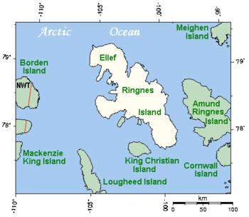
Closeup of Ellef Ringnes Island and neighbouring islands
|
|
 |
|
| Geography | |
|---|---|
| Location | Arctic Ocean |
| Coordinates | 78°30′N 102°15′W / 78.500°N 102.250°W |
| Archipelago | Sverdrup Islands Queen Elizabeth Islands Arctic Archipelago |
| Area | 11,295 km2 (4,361 sq mi) |
| Area rank | 69th |
| Highest elevation | 260 m (850 ft) |
| Highest point | Isachsen Dome |
| Administration | |
|
Canada
|
|
| Territory | Nunavut |
| Region | Qikiqtaaluk |
| Largest settlement | Isachsen (pop. 0) |
| Demographics | |
| Population | Uninhabited |
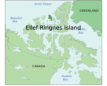
Ellef Ringnes Island is a large, empty island in the far north of Canada. It is located in the Arctic Ocean, east of Borden Island and west of Amund Ringnes Island. This island is part of the Sverdrup Islands and the Queen Elizabeth Islands, which are found in the Arctic Archipelago.
The island covers about 11,295 square kilometers (4,361 square miles). This makes it the 69th largest island in the world. It is also Canada's 16th largest island. The highest point on the island is about 260 meters (850 feet) tall.
The island was named after Ellef Ringnes, a brewer from Oslo, Norway. He helped pay for an expedition led by Otto Sverdrup. Europeans first saw the island in 1901 during Sverdrup's journey. Norway claimed the island from 1902 until 1930, when they gave up their claim to Canada.
Contents
History of Ellef Ringnes Island
The first Europeans to see Ellef Ringnes Island were Gunerius Isachsen and Sverre Hassel. They were part of the Second Norwegian Arctic Expedition, which explored the Arctic from 1898 to 1902. Otto Sverdrup led this expedition.
Discovery and Naming
Isachsen and Hassel first spotted Ellef Ringnes Island on April 23, 1901. They were exploring near Amund Ringnes Island. The very next day, they traveled across Hassel Sound and landed on the southern part of the island. Over the next 20 days, they explored all around Ellef Ringnes Island. Their maps and notes about the rocks were later published in Otto Sverdrup's book, New Land (1904). The island was named to honor Ellef Ringnes, who was a main supporter of the expedition.
Weather Station and Research
In 1948, Canada and the United States worked together to build a weather station on the island. This station was called Isachsen and was located on the west coast. It helped gather important weather information for 30 years.
The Isachsen weather station closed on September 19, 1978. After that, an automatic weather station took its place. This station was the only known place where people lived permanently on the island. From 1959 to 1961, the Polar Continental Shelf Project used Isachsen as a base. This project supports scientific research all across the Arctic.
The North Magnetic Pole
Ellef Ringnes Island is famous for being the last place visited by the Earth's wandering north magnetic pole. In 1994, two scientists, Larry Newitt from Canada and Charles Barton from Australia, studied the pole's location. They found that in 1994, the north magnetic pole was on the Noice Peninsula, in the southwest part of Ellef Ringnes Island.
Geology and Landforms
Ellef Ringnes Island has wide, flat areas and some hilly parts. These different landforms are due to the types of rocks and how they are structured. The island's edges have low, flat coastal areas.
Salt Domes
A special feature of the island's landscape is its domal structures, also known as salt domes. These are like big bumps or hills made of salt and other minerals that have pushed up from deep underground. These salt domes create the highest points on the island.
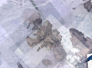
There are seven main salt domes on Ellef Ringnes Island: Dumbbells, Contour, Hoodoo, Malloch, Haakon, Helicopter, and Isachsen Dome. Isachsen Dome is the highest point on the island, reaching about 260 meters (850 feet) high. While most of the island is flat, these salt domes stand out clearly when seen from space.
Rock Types
Most of the rocks on the island are from the Jurassic and Cretaceous periods. These rocks are mostly different types of sandstone and shale. In the northern part of the island, there are also many gabbro and diabase dikes and sills. These are formations where molten rock has pushed into cracks in older rocks. The salt domes themselves are much older, from the Carboniferous period.
Flora and Fauna: Life in the Arctic
Ellef Ringnes Island is a very challenging place for plants and animals to live. This is because of its extremely cold Arctic environment. Along with some other islands in the northwestern Queen Elizabeth Islands, it is one of the most barren parts of the high Arctic.
Harsh Environment
People who have visited the island have described its bleakness. For example, explorer Vilhjalmur Stefansson visited in 1916 and wrote that he "did not see a blade of grass." He called it "the most barren" place he had ever seen. Summers on Ellef Ringnes Island are colder than at any other Arctic weather station. This means the island likely has fewer types of life than other ice-free Arctic lands of similar size.
Plants and Animals
Despite the harsh conditions, some life does exist. Scientists have found 49 different types of vascular plants (plants with roots, stems, and leaves) and about 85 types of fungi.
Only a few types of animals live on the island.
- There are 10 known species of mammals. These include muskox, Peary caribou, polar bears, and Arctic foxes.
- About 15 species of birds have been seen on the island.
See also
 In Spanish: Isla Ellef Ringnes para niños
 | Delilah Pierce |
 | Gordon Parks |
 | Augusta Savage |
 | Charles Ethan Porter |


