Sverdrup Islands facts for kids

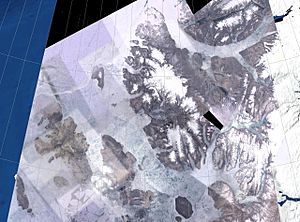
NASA Landsat photo of the Sverdrup Islands
From left to right: Ellef Ringnes, Amund Ringnes, and Axel Heiberg islands. |
|
 |
|
| Geography | |
|---|---|
| Location | Arctic Ocean |
| Coordinates | 78°30′N 95°00′W / 78.500°N 95.000°W |
| Archipelago | Queen Elizabeth Islands Canadian Arctic Archipelago |
| Major islands | Axel Heiberg, Ellef Ringnes, Amund Ringnes |
| Area | 66,000 km2 (25,000 sq mi) |
| Highest elevation | 2,210 m (7,250 ft) |
| Highest point | Outlook Peak |
| Administration | |
|
Canada
|
|
| Territory | Nunavut |
| Region | Qikiqtaaluk |
| Capital city | McGill Arctic Research Station |
| Demographics | |
| Population | 8 to 12 summer population |
| Pop. density | 0.000015 /km2 (3.9E-5 /sq mi) |
The Sverdrup Islands are a group of islands in the far north of Canada. They are part of the Queen Elizabeth Islands in Nunavut. These islands are located in the Arctic Ocean. They are found west of Ellesmere Island. Their location is between 77° and 81° North latitude and 85° to 106° West longitude.
Contents
Discovering the Sverdrup Islands
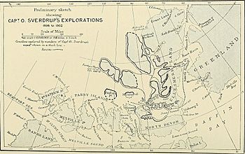
The Sverdrup Islands are named after Norwegian explorer Otto Sverdrup. He explored and mapped these islands between 1898 and 1902. Sverdrup used his ship, the Fram, for this important journey.
Who Lived There Before?
Even though Sverdrup explored them, some of these islands were already home to Inuit people. They had lived there for a long time before European explorers arrived.
Norway's Claim and Canada's Ownership
When Otto Sverdrup explored the islands, he claimed them for Norway. However, the Norwegian government did not show much interest in this claim at first. This changed in 1928. Norway then decided to use the islands in talks with the United Kingdom. They wanted to gain control over two other islands: Jan Mayen in the Arctic and Bouvet Island in the Antarctic.
On November 11, 1930, Norway officially agreed that Canada owned the Sverdrup Islands. Just eight days later, on November 19, 1930, the United Kingdom recognized Norway's ownership of Jan Mayen. This agreement settled who owned these different islands.
Geography of the Islands
The Sverdrup Islands are a group of many islands. Some are very large, while others are quite small. They are all found in the cold waters of the Arctic.
Main Islands in the Group
The biggest islands in this group include:
- Axel Heiberg Island
- Ellef Ringnes Island
- Amund Ringnes Island
- Cornwall Island
- Graham Island
- Meighen Island
- King Christian Island
- Stor Island
There are also many smaller islands scattered around these main ones.
Life on the Islands
For a while, there was a manned weather station called Isachsen on Ellef Ringnes Island. It operated from 1948 to 1978. Today, the only place that is regularly used is the McGill Arctic Research Station. This research station is located on Axel Heiberg Island. Scientists stay there during the summer months to study the Arctic environment.
Key Facts About the Main Islands
Here is a table showing some important facts about the largest islands in the Sverdrup group:
| Island | Peak | Height m |
Area km2 |
Rank Canada |
Rank World |
|---|---|---|---|---|---|
| Axel Heiberg | Outlook Peak | 2,211 | 43,178 | 7 | 32 |
| Ellef Ringnes | Isachsen Dome | 260 | 11,295 | 16 | 69 |
| Amund Ringnes | ... | 265 | 5,255 | 25 | 111 |
| Meighen | Meighen Icecap | 300 | 955 | 50 | 337 |
| King Christian | King Christian Mountain | 165 | 645 | 60 | 420 |
| Stor | ... | 500 | 313 | 87 | ... |
| Sverdrup | Outlook Peak | 2,211 | 66,000 | - | - |
See also
 In Spanish: Islas Sverdrup para niños
 | May Edward Chinn |
 | Rebecca Cole |
 | Alexa Canady |
 | Dorothy Lavinia Brown |


