
Cornwall Island (Nunavut) facts for kids

NASA Landsat photo of Cornwall Island
|
|

Cornwall Island, Nunavut
|
|
| Geography | |
|---|---|
| Location | Northern Canada |
| Coordinates | 77°37′N 094°52′W / 77.617°N 94.867°W |
| Archipelago | Queen Elizabeth Islands Canadian Arctic Archipelago |
| Area | 2,358 km2 (910 sq mi) |
| Length | 90 km (56 mi) |
| Width | 30 km (19 mi) |
| Highest elevation | 400 m (1,300 ft) |
| Highest point | McLeod Head |
| Administration | |
|
Canada
|
|
| Territory | Nunavut |
| Demographics | |
| Population | Uninhabited |
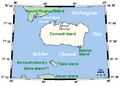
Cornwall Island is a small island located far north in Canada. It's part of the Canadian territory of Nunavut. This island is found near the center of a group of islands called the Queen Elizabeth Islands.
To the north, Cornwall Island is separated from Amund Ringnes Island by a water passage called Hendriksen Strait. To the south, it's separated from Devon Island by Belcher Channel. Cornwall Island is the largest of six islands in the Norwegian Bay, which is west of Ellesmere Island. The other islands in this bay are Buckingham, Ekins, Exmouth, Graham Island, and Table.
Contents
Island Size and Shape
Cornwall Island is about 90 kilometers (56 miles) long and 30 kilometers (19 miles) wide. Its total area is about 2,358 square kilometers (910 square miles). That's a pretty big piece of land!
Mountains and Coastlines
The island has some tall peaks. The highest one is McLeod Head, which stands about 400 meters (1,312 feet) tall. Another notable peak is Mount Nicolay, at 290 meters (951 feet). Both of these mountains are found on the north coast of the island.
The coastline of Cornwall Island has several interesting features. On the east side, you'll find Northeast Point and Gordon Head. To the south, there are Pell Point and Cape O'Brien. In the southwest part of the island, you can see Cape Butler.
Discovery and Naming
The first time Cornwall Island was seen by Europeans was on August 30, 1852. This discovery was made by Sir Edward Belcher, an explorer. He named the island in honor of Prince Edward, who was the Prince of Wales and Duke of Cornwall at the time.
Images for kids
-
A closer look at Cornwall Island

See also
 In Spanish: Isla Cornwall para niños
