
Canadian Arctic Archipelago facts for kids

The Canadian Arctic Archipelago is a huge group of islands in the Arctic. It's located north of Canada's main landmass. This area is also simply called the Arctic Archipelago.
There are about 36,563 islands here. They make up a large part of Northern Canada. This includes most of Nunavut and some of the Northwest Territories.
The archipelago has 94 very large islands. These are bigger than 130 square kilometers. Three of these islands are among the ten biggest in the world! There are also 36,469 smaller islands. The largest islands in this group, which are bigger than 10,000 square kilometers, are listed below:
| Name | Location* | Area | Area rank | Population (2001) |
|
|---|---|---|---|---|---|
| World | Canada | ||||
| Baffin Island | 507,451 km2 (195,928 sq mi) | 5 | 1 | 9,563 | |
| Victoria Island | 217,291 km2 (83,897 sq mi) | 9 | 2 | 1,707 | |
| Ellesmere Island | 196,236 km2 (75,767 sq mi) | 10 | 3 | 168 | |
| Banks Island | 70,028 km2 (27,038 sq mi) | 24 | 5 | 114 | |
| Devon Island | 55,247 km2 (21,331 sq mi) | 27 | 6 | 0 | |
| Axel Heiberg Island | 43,178 km2 (16,671 sq mi) | 32 | 7 | 0 | |
| Melville Island | 42,149 km2 (16,274 sq mi) | 33 | 8 | 0 | |
| Southampton Island | 41,214 km2 (15,913 sq mi) | 34 | 9 | 721 | |
| Prince of Wales Island | 33,339 km2 (12,872 sq mi) | 40 | 10 | 0 | |
| Somerset Island | 24,786 km2 (9,570 sq mi) | 46 | 12 | 0 | |
| Bathurst Island | 16,042 km2 (6,194 sq mi) | 54 | 13 | 0 | |
| Prince Patrick Island | 15,848 km2 (6,119 sq mi) | 55 | 14 | 0 | |
| King William Island | 13,111 km2 (5,062 sq mi) | 61 | 15 | 960 | |
| Ellef Ringnes Island | 11,295 km2 (4,361 sq mi) | 69 | 16 | 0 | |
| Bylot Island | 11,067 km2 (4,273 sq mi) | 72 | 17 | 0 | |
* NT = Northwest Territories, NU = Nunavut
Images for kids
-
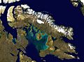
Satellite image of Baffin Island, the largest island by total area of the Arctic Archipelago
-
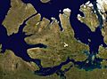
Satellite image of Victoria Island, second largest island, with Banks Island to the upper left and Prince of Wales Island to the upper right.
-
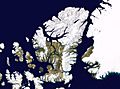
Satellite image montage showing Ellesmere Island and its neighbours, including Axel Heiberg Island (left of Ellesmere). Greenland is to the right in this photo.
-
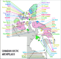
Reference map of Canadian Arctic Archipelago


See also
 In Spanish: Archipiélago Ártico Canadiense para niños
