
Axel Heiberg Island facts for kids

Closeup of Axel Heiberg Island
|
|

Location of Axel Heiberg Island
|
|
| Geography | |
|---|---|
| Location | Arctic Ocean |
| Coordinates | 79°26′N 090°46′W / 79.433°N 90.767°W |
| Archipelago | Sverdrup Islands Queen Elizabeth Islands Canadian Arctic Archipelago |
| Area rank | 32nd |
| Administration | |
| Demographics | |
| Population | 0 |
Axel Heiberg Island is a very large island located in the Arctic Ocean. It is the 31st biggest island in the world. It is also Canada's 7th largest island. The island covers an area of about 43,178 square kilometers (16,671 square miles).
Contents
Exploring Axel Heiberg Island
Long ago, the Inuit people lived on Axel Heiberg Island. However, no one was living there when it was explored. This happened around the year 1900. The explorer who found it was named Otto Sverdrup.
How the Island Got Its Name
Otto Sverdrup named the island after Axel Heiberg. Axel Heiberg was a manager at a Norwegian company. This company, called Ringnes, helped pay for Sverdrup's trip.
Who Owns the Island?
Other explorers visited the island in the early 1900s. For a while, Norway claimed the island. This lasted until 1930. Today, Axel Heiberg Island is part of Nunavut, Canada.
Images for kids
-
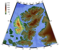
Topography of Axel Heiberg Island
-
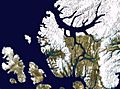
Satellite photo montage of Axel Heiberg Island
-
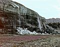
Front of advancing White Glacier, Axel Heiberg Island, June 23, 1975. The steep glacier front with waterfalls is caused by cold glacier ice, the ice cliff shows shear moraines with debris, part of the well-known Thompson Glacier with its push moraine at right. Foreground: vegetation cover of Saxifraga.


See also
 In Spanish: Isla Axel Heiberg para niños
