Bylot Island facts for kids

Bylot Island
|
|
 |
|
| Geography | |
|---|---|
| Location | Lancaster Sound |
| Coordinates | 73°16′N 78°30′W / 73.267°N 78.500°W |
| Archipelago | Canadian Arctic Archipelago |
| Area | 11,067 km2 (4,273 sq mi) |
| Area rank | 72nd |
| Highest elevation | 1,951 m (6,401 ft) |
| Highest point | Angilaaq Mountain |
| Administration | |
| Territory | Nunavut |
| Region | Qikiqtaaluk |
| Demographics | |
| Population | Uninhabited |
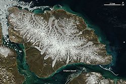
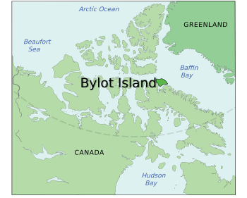
Bylot Island is a large island located in Nunavut, Canada. It sits just north of Baffin Island. Eclipse Sound and Navy Board Inlet separate it from Baffin Island. To its northwest is Parry Channel.
Bylot Island is huge, covering about 11,067 square kilometers. This makes it the 71st largest island in the world. It is also Canada's 17th largest island. The island stretches about 180 kilometers from east to west. It is about 110 kilometers from north to south. Bylot Island is one of the biggest uninhabited islands globally. No one lives there permanently. However, Inuit people from Pond Inlet often visit Bylot Island. They have a seasonal hunting camp southwest of Cape Graham Moore.
Island Geography and Nature
The mountains on Bylot Island are part of the Byam Martin Mountains. These are a section of the Baffin Mountains. They belong to the larger Arctic Cordillera mountain range. Important mountains here include Angilaaq Mountain, Malik Mountain, Mount St. Hans, and Mount Thule.
Tay Bay is found on the west coast of the island. The tall cliffs along the coastline are made of dolomite rock. This rock formed a very long time ago. Bylot Island also has many glaciers. The western shore faces Navy Board Inlet.
The northern shore of the island faces Lancaster Sound. This area is a special place for polar bears. Female polar bears often use it as a den to have their cubs. Many sea animals live in the waters around Bylot Island. These include beluga whales, bowhead whales, harp seals, narwhals, and ringed seals.
History of Bylot Island
The island is named after Robert Bylot. He was an Arctic explorer. He was the first European to see the island in 1616. Later, in 1872, a whaling captain named William Adams proved it was an island. Before that, people were not sure if it was connected to other land.
In the 2000s, a company started mining activities nearby. They began to build a road and harbor in Milne Bay. This area is close to Bylot Island. Milne Bay is a small arm of water. It separates Bylot Island from Baffin Island.
Protected Areas and Wildlife
Most of Bylot Island is part of Sirmilik National Park. This park protects the island's amazing wildlife. It is home to huge groups of birds. These include thick-billed murres and black-legged kittiwakes. Many greater snow geese also live here.
The eastern part of the island is a special protected area. It is called the Bylot Island Migratory Bird Sanctuary. This sanctuary helps protect birds that travel long distances.
Three areas on the island are very important for birds. They are called Canadian Important Bird Areas. These are Cape Graham Moore, Cape Hay, and the Southwest Bylot Plain. These places provide safe homes for many different bird species.
See also

- In Spanish: Isla Bylot para niños
 | Precious Adams |
 | Lauren Anderson |
 | Janet Collins |


