Parry Channel facts for kids
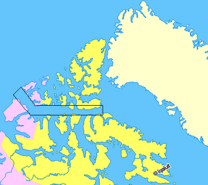
The Parry Channel is a natural waterway located in the middle of the Canadian Arctic Archipelago. This means it's a long, narrow stretch of water that connects larger bodies of water. It runs from east to west, linking Baffin Bay in the east to the Beaufort Sea in the west.

Most of the channel is in Nunavut, a territory in northern Canada. The western part, west of 110° West, is in the Northwest Territories.
This channel is very important because its eastern end is the main way to enter the famous Northwest Passage. The Northwest Passage is a sea route through the Arctic Ocean, connecting the Atlantic and Pacific Oceans. The Parry Channel also separates the Queen Elizabeth Islands to the north from the rest of Nunavut to the south.
Exploring the Parry Channel
The Parry Channel is made up of several smaller parts, stretching from east to west. These include Lancaster Sound, Barrow Strait, Viscount Melville Sound, and the McClure Strait.
Many islands and other waterways surround the channel. To the south, you'll find Baffin Island, Somerset Island (Nunavut), Prince of Wales Island (Nunavut), and Victoria Island (Canada). Important passages leading south include Prince Regent Inlet and Peel Sound.
To the north, the channel is bordered by Devon Island, Cornwallis Island (Nunavut), Bathurst Island (Nunavut), Melville Island, and Prince Patrick Island.
How the Parry Channel Got Its Name
The Parry Channel is named after a brave Arctic explorer named William Edward Parry. In 1819, Parry sailed into this channel. He managed to get as far west as Melville Island. However, thick ice at the McClure Strait blocked his ship, stopping him from going any further.
It took many years for another ship to reach this far west. The next vessel to explore this part of the channel was part of the Edward Belcher expedition in 1850.
See also
 In Spanish: Canal de Parry para niños
 | Sharif Bey |
 | Hale Woodruff |
 | Richmond Barthé |
 | Purvis Young |

