
Byam Martin Mountains facts for kids
Quick facts for kids Byam Martin Mountains |
|
|---|---|

Byam Martin Mountains
|
|
| Highest point | |
| Peak | Angilaaq Mountain |
| Elevation | 1,951 m (6,401 ft) |
| Geography | |

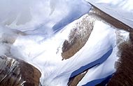
USGS satellite image of Bylot Island, including the Byam Martin Mountains
|
|
| Country | Canada |
| State/Province | Nunavut |
| Parent range | Baffin Mountains |
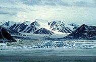
The Byam Martin Mountains are a tough and beautiful mountain range. They stretch from east to west across Bylot Island in Nunavut, Canada. These mountains are among the most northern in the whole world! They are part of the larger Baffin Mountains, which are themselves part of the huge Arctic Cordillera mountain system.
The tallest peak here is Angilaaq Mountain, standing at 1,951 m (6,401 ft) (about 6,400 feet) high. It is located near the center of Bylot Island. The Byam Martin Mountains have sharp peaks and long ridges. Deep valleys filled with glaciers separate these peaks. These mountains have been greatly shaped by the movement of glaciers over time.
It's very hard for people to live permanently in the Byam Martin Mountains. However, Inuit people from Pond Inlet and other places often travel to this mountain range.
The Byam Martin Mountains are made of very old rocks. These include igneous (volcanic) crystalline rocks from the Archean period. There are also metamorphic rocks like gneiss from the Proterozoic period.
Contents
Exploring the Byam Martin Mountains
People have explored the Byam Martin Mountains for many years. It's a challenging place because of its remote location and icy conditions.
Early Expeditions
The first known trip into the Byam Martin Mountains was in 1939. An explorer named Pat Baird crossed Bylot Island. He traveled from the Aktineq Glacier to Bathurst Bay on the east coast. He then returned by following the Sermilik Glacier.
On June 7, 1939, Pat Baird climbed a mountain that didn't have a name yet. It was about 6,000 feet (1,829 meters) tall.
In 1954, an American climber named Ben Ferris climbed Mount Thule. This mountain is 1,711 meters (5,614 feet) high. Ben Ferris was part of the Harvard Mountaineering Club.
Later Explorations
In 1963, a British explorer named Bill Tilman sailed his boat to the north coast of the island. He then traveled across the island from north to south. However, he did not climb any of the very large peaks.
Laurie Dexter, an Anglican minister, also explored and climbed peaks. He lived in the Arctic and focused on the southern coast. In 1974, Dr. George Van Brunt Cochran climbed an unnamed peak. This peak was west of the Narsarsuk Glacier on the south coast.
Canadian Expeditions
In 1977, a Canadian team led by Rob Kelly crossed the island. They traveled from the northwest to the southeast. This team climbed 20 different peaks. They also climbed the unnamed peak that Pat Baird had climbed in 1939.
Another Canadian team explored the mountains in June 1981. This group was led by Jack DeBruyn. They were from the Grant MacEwan Mountain Club in Edmonton, Alberta. They crossed the island from the northwest to the south. They climbed 15 peaks, and 14 of these were climbed for the very first time! They also climbed Pat Baird's unnamed peak on July 3, 1981.
In 1984, another Canadian team, led by Mike Schmidt, explored the area. They traveled from the north to the southeast. This team climbed 28 peaks, with 16 of them being first ascents.
Gallery
-
Byam Martin Mountains
-
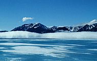
Byam Martin Mountains viewed from the foggy sea
-
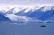
Kaparoqtalik Glacier in the southern Byam Martin Mountains
-
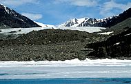
Nararsuk Glacier in the southern Byam Martin Mountains
-

Girmilik Glacier in the southern Byam Martin Mountains
-
Unnamed glacier in the eastern Byam Martin Mountains


