
Southampton Island facts for kids

Southampton Island within Nunavut
|
|
| Lua error in Module:Location_map at line 530: Unable to find the specified location map definition: "Module:Location map/data/Southampton Island.png" does not exist. | |

Southampton
Location in Nunavut

Southampton
Location in Canada
|
|
| Geography | |
|---|---|
| Location | Hudson Bay at Foxe Basin |
| Coordinates | 64°30′N 084°30′W / 64.500°N 84.500°W |
| Archipelago | Arctic Archipelago |
| Area | 41,214 km2 (15,913 sq mi) |
| Area rank | 34th |
| Highest elevation | 625 m (2,051 ft) |
| Highest point | Mathiasen Mountain |
| Administration | |
|
Canada
|
|
| Nunavut | Nunavut |
| Region | Kivalliq |
| Largest settlement | Coral Harbour (pop. 834) |
| Demographics | |
| Population | 834 |
| Ethnic groups | Inuit |

Southampton Island is a very large island in Canada. It is one of the biggest islands in the Canadian Arctic Archipelago. You can find it at the entrance to Hudson Bay. This island is part of the Kivalliq Region in the Nunavut Territory.
Contents
About Southampton Island
Southampton Island covers a huge area of about 41,214 square kilometers (15,913 square miles). This makes it the 34th largest island in the entire world. It is also Canada's 9th biggest island.
Where is Southampton Island?
The island is located in the northern part of Canada. It sits right where the large Hudson Bay meets the Foxe Basin. This area is known for its cold Arctic climate.
Life on the Island
The only town on Southampton Island is called Coral Harbour. In the Inuit language, this town is known as Salliq. According to the 2011 census, about 834 people live there. Most of the people living on the island are Inuit.
Images for kids
-
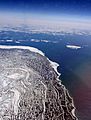
Glacial rebound on Southampton Island. Snow-enhanced paleo-strand lines from the last 10,000 years, during the spring thaw, 2011
-
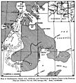
Capt. Capt. George Comer's 1913 map of Southampton.


See also
 In Spanish: Isla de Southampton para niños
