
Buckingham Island facts for kids

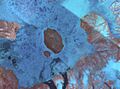
Satellite picture of Buckingham among other islands
|
|

Buckingham Island
Location in Nunavut

Buckingham Island
Location in Canada
|
|
| Geography | |
|---|---|
| Location | Northern Canada |
| Coordinates | 77°12′N 91°00′W / 77.200°N 91.000°W |
| Archipelago | Queen Elizabeth Islands Canadian Arctic Archipelago |
| Area | 137 km2 (53 sq mi) |
| Length | 14 km (8.7 mi) |
| Width | 10 km (6 mi) |
| Highest elevation | 150 m (490 ft) |
| Highest point | Mount Windsor |
| Administration | |
|
Canada
|
|
| Territory | Nunavut |
| Demographics | |
| Population | Uninhabited |
Buckingham Island is a cool island located in the far north of Canada. It's part of the Canadian Arctic Archipelago, a group of many islands in the Arctic Ocean. This island is found in a place called Norwegian Bay, which is in the Canadian territory of Nunavut.
Buckingham Island is not very big. It is about 10 kilometers (6 miles) wide. Its total area is 137 square kilometers (53 square miles). It is part of the Queen Elizabeth Islands, a large group of islands in the Canadian Arctic.
Contents
Where is Buckingham Island?
Buckingham Island is located in a very remote part of Canada. It sits southwest of another island called Graham Island. It is also about 50 kilometers (31 miles) east of Cornwall Island. These islands are all in the Arctic, which means they are very cold and often covered in ice.
Island Features
The highest point on Buckingham Island is a peak named Mount Windsor. Both the island and its highest peak were named after royal palaces. This was done by explorers who often named new places after important people or places back home.
Who Explored Buckingham Island?
One of the early explorers who visited the area around Buckingham Island was Captain Edward Belcher. He was searching for another famous explorer, John Franklin, between 1852 and 1854. Belcher described the icy surroundings of the island during his journey.
Images for kids
-
Satellite picture of Buckingham among other islands
