
Hans Island facts for kids
| Disputed island Native name: Tartupaluk, ᑕᕐᑐᐸᓗᒃ Other names: Hans Ø, Île Hans |
|
|---|---|
 |
|
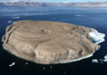
| Hans Island from the east (Greenland) side | |
| Geography | |
 |
|
| Location | Kennedy Channel, Nares Strait |
| Coordinates | 80°49′40″N 66°27′20″W / 80.82778°N 66.45556°W |
| Area | 1.3 km2 (0.5 sq mi) |
| Length | 1,290 m (0.8 mi) |
| Width | 1,199 m (0.745 mi) |
| Administered by | |
| {{country data Disputed |flag/core|name=Disputed |variant=|size=}} | |
| Claimed by | |
| {{country data {{{country claim}}} |flag/core|name={{{country claim}}} |variant=|size=}} | |
| {{country data |
|
| {{country data |
|
| Demographics | |
| Population | Uninhabited (as of 2021) |
| Density | 0/km² |
| Ethnic groups | None |
.png)
Hans Island (called Tartupaluk in Greenlandic and Hans Ø in Danish) is a small, empty island. It is about 1.3 square kilometers in size, which is roughly the size of 200 football fields. The island is located in the middle of the Kennedy Channel, a narrow waterway that separates Ellesmere Island in Canada from northern Greenland. This channel is part of the Nares Strait, which connects Baffin Bay to the Lincoln Sea.
Hans Island is the smallest of three islands in the Kennedy Channel. The other two are Franklin Island and Crozier Island. The channel here is about 35 kilometers wide. Because of its location, the island is claimed by both Canada and Denmark (on behalf of Greenland). A theoretical line drawn down the middle of the strait goes right through the island.
People from the Inuit community have likely used the island for hunting since the 14th century. Today, the closest populated places are Alert, Canada (198 km away, with 62 people), and in Greenland, Siorapaluk (349 km away, with 68 people) and Qaanaaq (379 km away, with 656 people).
What's in a Name?
The island is named after Hans Hendrik, whose native Greenlandic name was Suersaq. Hendrik was an important Arctic explorer and translator. He worked on several American and British expeditions to the Arctic between 1853 and 1876.
For a long time, people thought the island was named during Charles Francis Hall's expedition between 1871 and 1873. The first time the island and its name appeared in writing was in Charles Henry Davis's book Narrative of the North Polar expedition (1876). The island also appeared on a map that came with the book.
However, it was later discovered that the island was named much earlier. In 1853, explorer Elisha Kent Kane was on an expedition. He wrote about finding a small, rocky island and naming it Hans Island after his Greenlandic helper, Hans Hendrik. This means the island was discovered and named in 1853, not in the 1870s.
Many place names in this Arctic region have changed over time. For example, the name of the Nares Strait itself was not officially agreed upon by the Danish and Canadian governments until 1964.
History and the Island Dispute
Early Explorations
The Inuit people of northern Greenland and Canada probably knew about Hans Island for hundreds of years. In the mid-1800s, Europeans began exploring this Arctic area. They were looking for the missing British explorer John Franklin and trying to find the Northwest Passage or reach the North Pole.
From 1920 to 1923, a Danish expedition called the "Celebration Expedition" accurately mapped the northern coast of Greenland. In 1933, an international court ruled that Greenland belonged to Denmark. Denmark argues that Hans Island is geologically part of Greenland, so it should belong to Denmark based on that ruling.
Since the 1960s, many studies have been done around Hans Island. These studies looked at ice movement, mapped the area, and searched for resources. A Canadian company, Dome Petroleum Ltd., even did research on and around Hans Island from 1980 to 1983.
1973 Border Agreement
In 1972, a team of Canadian and Danish experts worked together to find the exact location of Hans Island. When Canada and Denmark were discussing their maritime boundary (the border in the sea) in 1973, both countries claimed Hans Island. They could not agree on who owned it.
The sea border north and south of Hans Island was set in a treaty signed in 1973. This treaty drew a line using 127 points from the Davis Strait all the way to the end of the Robeson Channel. However, the treaty did not draw a line between two specific points where Hans Island is located. This left the island's ownership undecided.
In 1984, a historian named Kenn Harper wrote an article about Hans Island. This article got attention in both Denmark and Canada. It was sparked when Harper met a scientist from Dome Petroleum who had been doing ice research on the island.
Around the same time, Canada and Denmark were signing an agreement to protect the marine environment in the Nares Strait. They also talked about sharing research on Hans Island, but this was never formally agreed upon. Both countries decided to avoid doing anything that might harm future talks about the island.
However, in 1984, the Danish Minister for Greenland visited the island. He planted the Danish flag and left a message saying, "Welcome to the Danish Island." He also left a bottle of schnapps, a traditional Danish spirit. The Canadians soon visited and left their own flag and a bottle of Canadian Club whisky. This friendly back-and-forth of leaving flags and bottles of alcohol became known as the "Whisky War."
Media Attention and Ongoing Talks

The dispute over Hans Island became widely known in 2004 after Canadian newspapers wrote about it. Soon, news organizations around the world picked up the story. The Arctic region has long been a place where countries have made claims. Canada, Denmark, Iceland, Russia, and Norway all see parts of the Arctic seas as their own. Other countries, like the United States, see it as international waters.
In 2005, the Canadian Defence Minister, Bill Graham, visited Hans Island. Denmark was not happy about this visit and complained. However, both countries have kept a sense of humor about the dispute. As a Danish official once said, "when Danish military go there, they leave a bottle of Schnapps. And when Canadian military forces come there, they leave a bottle of Canadian Club and a sign saying, 'Welcome to Canada.'"
In 2012, Canada and Denmark held talks about the island. They discussed either sharing the island (called a condominium) or splitting its ownership in half. If the island were split, it would give both Canada and Denmark a second land neighbor. Currently, Canada only borders the United States, and Denmark only borders Germany.
On May 23, 2018, Canada and Denmark announced they would create a special group to decide the border between Canada and Greenland, including the future of Hans Island.
Google Fight
The "Google fight" or "Google war" was a fun part of the dispute. It involved advertisements on the search engine Google that promoted either Danish or Canadian ownership of Hans Island.
In 2005, a person in Toronto saw an ad on Google that said, "Hans Island is Greenland. Greenland natives have used the island for centuries." This ad linked to a Danish government website. In response, the Toronto resident put up his own ad on Google, which linked to his website, supporting Canada's claim to the island. The Danish ambassador to Canada later said that the Danish government did not pay for the first ad.
Images for kids
-
Hans Island from the east (Greenland) side
-
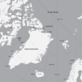
Location of Hans Island, between Greenland and Ellesmere Island
-
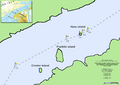
Map of part of Kennedy Channel, with the disputed Island.
-
Hans Island. NASA Landsat 7 image
See also
 In Spanish: Isla Hans para niños
