
Kennedy Channel facts for kids

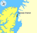
The Kennedy Channel is a sea passage in the Arctic. It lies between Greenland and Ellesmere Island, which is Canada's most northern island. This channel is a key part of the Nares Strait.
Contents
How the Channel Got Its Name
The Kennedy Channel was named by an explorer named Elisha Kane. He named it around 1854. Kane was on his second trip to the Arctic. He was looking for the lost Franklin expedition.
It's not fully clear who the channel was named after. Kane might have named it for William Kennedy. William Kennedy was another explorer. Kane had met him a few years earlier. They were both searching for the lost Franklin expedition.
However, most historians think it was named for John Pendleton Kennedy. He was the United States Secretary of the Navy from 1852 to 1853. The Secretary of the Navy is a government official. They are in charge of the country's navy. Kane's second Arctic trip happened under John Pendleton Kennedy's direction.
Geography of Kennedy Channel
The Kennedy Channel is part of the Nares Strait. It connects Kane Basin with Hall Basin. From the south, the channel starts between Cape Lawrence and Cape Jackson. Where it meets Hall Basin, it is marked by Cape Baird and Cape Morton.
The channel is about 130 kilometers (81 miles) long. It is between 24 and 32 kilometers (15 to 20 miles) wide. The water in the channel is usually between 180 and 340 meters (590 to 1,115 feet) deep.
Islands in the Channel
The Kennedy Channel has a few islands. One important island is Hans Island. Both Canada and Denmark claim this island. It is located close to the middle of the channel. It is about 1,000 meters closer to Greenland's coast.
The channel also has two other islands. These are Franklin Island and Crozier Island. They are much closer to the coast of Greenland. Because of this, they belong to Greenland. Hannah Island is also in the area. It is located at the mouth of the Bessel Fjord. This is northeast of Cape Bryan.
Images for kids
-
Kennedy Channel, Nunavut, Canada. Ellesmere Island, Nunavut Greenland
See also
 In Spanish: Canal Kennedy para niños
