Kane Basin facts for kids
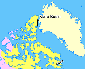
The Kane Basin is a large waterway in the Arctic. It lies between Greenland and Ellesmere Island, which is Canada's most northern island. This basin connects Smith Sound to Kennedy Channel. It is also part of the larger Nares Strait.
The Kane Basin is about 180 kilometers (112 miles) long. At its widest point, it stretches about 130 kilometers (81 miles).
Naming the Kane Basin
The Kane Basin is named after Elisha Kane. He was an explorer who crossed this area in 1854. Kane was on an important journey to find the lost Franklin expedition.
Originally, Elisha Kane called this area "Peabody Bay." He did this to honor George Peabody. Mr. Peabody was a kind person who gave a lot of money to help fund Kane's expedition. Today, Peabody Bay is a smaller bay. It is located on the eastern side of the Kane Basin. It is also near the southwestern end of the huge Humboldt Glacier.
Location and Importance
The Kane Basin is a key part of the Nares Strait. This strait is a narrow waterway. It separates Greenland from Canada's Arctic islands. These waters are very cold and often covered in ice. They are important for understanding the Arctic environment.
See also

- In Spanish: Cuenca Kane para niños


