Hall Basin facts for kids
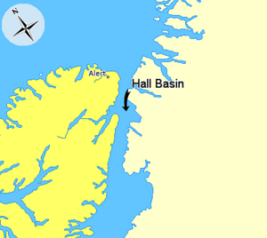
Hall Basin is a waterway in the Arctic region. It is located between Hall Land in Greenland on its western side and Ellesmere Island in Canada on its eastern side. Ellesmere Island is Canada's most northern island.
Hall Basin was named after Charles Francis Hall. He was an American explorer who studied the polar regions.
Where is Hall Basin Located?
Hall Basin is part of a larger waterway called Nares Strait. You can find its entrance between two capes. These are Cape Baird on the eastern coast of Ellesmere Island and Cape Morton on the northwestern coast of Greenland.
To the north of Hall Basin is Robeson Channel. To its south is Kennedy Channel. These are other important waterways in the Arctic.
What Does Hall Basin Look Like?
Hall Basin does not have a perfect shape. It is quite irregular. On its western side, you will find the entrance to Lady Franklin Bay. This area has many deep inlets and long, narrow sea channels called fjords.
The eastern side of Hall Basin is smoother. However, it includes the Petermann Fjord. This fjord is fed by the large Petermann Glacier at its southern end.
See also
 In Spanish: Cuenca Hall para niños
 | Claudette Colvin |
 | Myrlie Evers-Williams |
 | Alberta Odell Jones |


