Lincoln Sea facts for kids
Quick facts for kids Lincoln Sea |
|
|---|---|

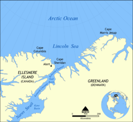
Map of the Lincoln Sea
|
|
| Coordinates | 83°N 58°W / 83°N 58°W |
| Type | Sea |
| Basin countries | Canada and Greenland |
| Surface area | 64,000 km2 (25,000 sq mi) |
| Average depth | 257 m (843 ft) |
| Water volume | 16,000 km3 (1.3×10¹⁰ acre⋅ft) |
| Frozen | Practically all year round |
The Lincoln Sea (also called Mer de Lincoln in French and Lincolnhavet in Danish) is a part of the Arctic Ocean. It stretches from Cape Columbia in Canada on the west to Cape Morris Jesup in Greenland on the east. The northern edge of the sea is a straight line connecting these two capes.
This sea is covered with sea ice almost all year round. It has some of the thickest sea ice in the Arctic Ocean, which can be up to 15 m (49 ft) thick. The water in the Lincoln Sea is usually between 100 m (330 ft) and 300 m (980 ft) deep. Most of the time, water and ice from the Lincoln Sea flow into Robeson Channel, which is the northernmost part of Nares Strait.
The sea was named after Robert Todd Lincoln, who was the United States Secretary of War at the time. It was named during an Arctic trip led by Adolphus Greely between 1881 and 1884.
Alert, the most northern station in Canada, is the only town or settlement on the coast of the Lincoln Sea.
To the east of the Lincoln Sea (past Cape Morris Jesup) is another body of water called the Wandel Sea.
Contents
Ocean Currents and Water Movement
It's very hard to study the Lincoln Sea because of the thick ice that covers it all year. Before the 1980s, scientists could only take measurements from low-flying planes or from ice islands near the coasts of Greenland and the Canadian Arctic Archipelago. The harsh environment made it difficult to go further into the sea.
However, between 1989 and 1994, a project called Spinnaker used special tools to measure water temperature and salinity (how salty the water is) deep inside the Lincoln Sea. These measurements helped scientists understand how water moves in and around the sea.
Scientists believe that strong currents flow along the edges of the Arctic Ocean. These currents are very important for how water moves around the Arctic. For example, water from the Pacific Ocean flows in a counter-clockwise direction along the northern coast of Canada, passing through the Lincoln Sea. Water from the Atlantic Ocean also flows into and out of the Arctic basin near Greenland.
These different ocean waters meet in the Lincoln Sea. This creates unique layers of water with different temperatures and saltiness. Measurements show that the water from the Pacific and Atlantic oceans stay somewhat separate, which is a key feature of the Lincoln Sea's water makeup.
The Lincoln Sea has three main types of water:
- Water close to the shore: Here, both temperature and saltiness increase as you go deeper towards the seafloor.
- Water further out on the shelf: This water is similar to what's found in the Canadian basin, meaning it's like water from the Pacific Ocean.
- Water north of the shelf: This water mixes with the larger currents of the Arctic basin and shows characteristics similar to water from the Eurasian basin.
A strong current also flows along the sloping edge of the Lincoln Sea shelf. This current helps move water around the Arctic. It has been found to flow continuously and is part of a larger system of currents that stretches between Alaska and Greenland along the northern Canadian islands.
Sea Ice Conditions
In 2004 and 2005, scientists used helicopters with special equipment to measure the thickness of the sea ice in the Lincoln Sea. They found that south of 84°N, the ice is mostly "multi-year ice," which means it has survived several summers. This ice is very thick, ranging from 3.9 m (13 ft) to 4.2 m (14 ft).
Closer to the Lincoln Polynya (an area of open water), there is "first-year ice," which is ice that has formed in the past year. This ice is thinner, between 0.9 m (3.0 ft) and 2.2 m (7.2 ft) thick. These helicopter measurements matched what satellites and ground observations showed.
Floating buoys have also shown that the sea ice drifts southward towards Ellesmere Island and Nares Strait. Scientists believe that the strong currents in the Lincoln Sea play an important role in moving this thick sea ice out of the Arctic region.
Most of the sea ice that leaves the Arctic Ocean flows out near Greenland through the Fram Strait. It was once thought that no sea ice left the Arctic through the Canadian islands, but this is not true. Even though the Lincoln Sea has very thick, old ice and seemed like a dead end, studies show that a large area of this multi-year ice (about 22,500 square kilometers) drains through the Nares Strait each year. During the Northern Hemisphere winter, some new ice forms, but overall, a significant amount of ice still leaves this way. However, the amount of ice leaving through the Nares Strait is much less than what leaves through the Fram Strait.
Border Dispute
After 1973, a small disagreement came up between Canada and Denmark about a 200-square-kilometer part of the Lincoln Sea. This happened when the two countries signed a treaty to set their offshore border north of Canada's Ellesmere Island and Danish-controlled Greenland. However, some parts of the border were not clearly defined.
Canada's main concern in this dispute was that Denmark included Beaumont Island (Greenland) when figuring out the border. The border in that area is supposed to be drawn exactly halfway between points along each country's coastline. Canada argued that Beaumont Island is too small and unimportant to be used by Greenland to help decide the international border.
However, this issue has remained a minor problem between Canada and Denmark.
Geographical Limits
The International Hydrographic Organization describes the boundaries of the Lincoln Sea as follows:
- To the North: From Cape Columbia to Cape Morris Jesup (in Greenland).
- To the South: From Cape Columbia, along the northeastern shore of Ellesmere Island to Cape Sheridan, then to Cape Bryant (in Greenland), and along the coast of Greenland to Cape Morris Jesup.
See also
 In Spanish: Mar de Lincoln para niños
 | Ernest Everett Just |
 | Mary Jackson |
 | Emmett Chappelle |
 | Marie Maynard Daly |


