
Sachs Harbour facts for kids
Quick facts for kids
Sachs Harbour
Ikaahuk (Inuinnaqtun)
|
|
|---|---|
 |
|

Sachs Harbour
Location in Northwest Territories

Sachs Harbour
Location in Canada
|
|
| Country | Canada |
| Territory | Northwest Territories |
| Region | Inuvik Region |
| Constituency | Nunakput |
| Census division | Region 1 |
| First permanent settlement | 1929 |
| Incorporated (hamlet) | 1 April 1986 |
| Area | |
| • Land | 272.22 km2 (105.10 sq mi) |
| Elevation | 86 m (282 ft) |
| Population
(2021)
|
|
| • Total | 104 |
| • Density | 0.4/km2 (1/sq mi) |
| Time zone | UTC−07:00 (MST) |
| • Summer (DST) | UTC−06:00 (MDT) |
| Canadian Postal code |
X0E 0Z0
|
| Area code(s) | 867 |
| Telephone exchange | 690 |
| - Living cost | 192.5 |
| - Food price index (2019) | 197.4 |
| Sources: Department of Municipal and Community Affairs, Prince of Wales Northern Heritage Centre, Canada Flight Supplement 2018 figure based on Edmonton = 100 2019 figure based on Yellowknife = 100 |
|
Sachs Harbour is a small community in the Northwest Territories, Canada. It is located on the southwestern coast of Banks Island. This makes it the only permanent settlement on the entire island. In 2021, about 104 people lived there.
Contents
What's in a Name?
The town got its name from a ship called the Mary Sachs. This ship was part of a big trip to the Arctic between 1913 and 1916. The traditional name for this area is Ikaahuk. In the local language, Ikaahuk means "place where one crosses."
A Look Back in Time
People have lived on Banks Island for a very long time. Scientists have found old sites from about 1500 BCE. These early people were part of the Pre-Dorset culture. Later, different groups, like the Dorset culture, lived in the southern parts of the island.
Around 800 BCE to 1000 CE, fewer people visited the northern part of Banks Island. Then, from 1000 to 1450, the Thule culture lived in several places on the island. But the weather got much colder during a time called the Little Ice Age. Because of this, the island was likely empty until the Inuvialuit people arrived in the 1600s.
An explorer named Sir William Edward Parry first saw Banks Island in 1820. He named it "Banks Land" to honor Sir Joseph Banks. Sachs Harbour itself started in 1929. That's when several Inuit families moved there to trap animals. It officially became a hamlet (a small village) in 1986.
There's also a bay called Mercy Bay on the north side of Banks Island. It's famous because a ship named the Investigator got stuck there in the ice for about three years. This ship was looking for John Franklin's lost expedition. The crew had to leave the ship behind.
How People Make a Living
The people of Sachs Harbour mostly rely on hunting and trapping for their jobs. Tourism is also starting to grow a little. The town is very close to the ocean.
Residents often go ice fishing in the Amundsen Gulf and the Beaufort Sea. Every spring, there's a special hunt for geese. Sachs Harbour is also known for having the biggest commercial muskox hunts in Canada.
Sometimes, people find jobs in oil and gas exploration. There's a lot of oil and natural gas believed to be under the Beaufort Sea.
Aulavik National Park
Sachs Harbour is the main office for Aulavik National Park. The park's Visitor Reception Centre is right in Sachs Harbour. This park is on the northern part of Banks Island. It's managed together by Parks Canada and the people of Sachs Harbour and the wider Inuvialuit community. The Visitor Centre teaches visitors about the park and Inuvialuit culture. It's also a place for community events.
People and Languages
In 2021, the Canadian Census counted 104 people living in Sachs Harbour. This was just a small increase from 103 people in 2016. The two main languages spoken in the town are Inuinnaqtun (a type of Inuvialuktun) and English. Sachs Harbour is the only place where people live permanently on Banks Island.
| Federal census population history of Sachs Harbour | ||
|---|---|---|
| Year | Pop. | ±% |
| 1976 | 163 | — |
| 1981 | 161 | −1.2% |
| 1986 | 158 | −1.9% |
| 1991 | 125 | −20.9% |
| 1996 | 135 | +8.0% |
| 2001 | 114 | −15.6% |
| 2006 | 122 | +7.0% |
| 2011 | 112 | −8.2% |
| 2016 | 103 | −8.0% |
| 2021 | 104 | +1.0% |
| Source: Statistics Canada |
||
| Annual population estimates | |||||||||||||||||||||||||||||||||||||||||||||||||||||||||||||||||||||||||||||||
|---|---|---|---|---|---|---|---|---|---|---|---|---|---|---|---|---|---|---|---|---|---|---|---|---|---|---|---|---|---|---|---|---|---|---|---|---|---|---|---|---|---|---|---|---|---|---|---|---|---|---|---|---|---|---|---|---|---|---|---|---|---|---|---|---|---|---|---|---|---|---|---|---|---|---|---|---|---|---|---|
|
|
||||||||||||||||||||||||||||||||||||||||||||||||||||||||||||||||||||||||||||||
| Sources: NWT Bureau of Statistics (2008 - 2019), NWT Bureau of Statistics (2001 - 2017) | |||||||||||||||||||||||||||||||||||||||||||||||||||||||||||||||||||||||||||||||
Town Services
Sachs Harbour has a few important services. There's a small Royal Canadian Mounted Police office with two officers. There's also a health centre with one nurse. Northwestel provides phone and internet services.
The local hunters and trappers association helps organize big-game hunts for animals like muskox and polar bears. Large amounts of food and other supplies arrive by barge in the summer. Flights from Inuvik, which is about 325 miles away, come all year round to the Sachs Harbour (David Nasogaluak Jr. Saaryuaq) Airport.
Geography and Climate
Sachs Harbour is in the Arctic tundra climate zone. This means it has very long and cold winters. Many people in the community know a lot about the weather, permafrost (ground that stays frozen), and how the land changes. This knowledge is important for their hunting, fishing, and travel.
| Climate data for Sachs Harbour (Sachs Harbour (David Nasogaluak Jr. Saaryuaq) Airport} Climate ID: 2503650; coordinates 72°00′N 125°16′W / 72.000°N 125.267°W; elevation: 86.3 m (283 ft); 1981–2010 normals |
|||||||||||||
|---|---|---|---|---|---|---|---|---|---|---|---|---|---|
| Month | Jan | Feb | Mar | Apr | May | Jun | Jul | Aug | Sep | Oct | Nov | Dec | Year |
| Record high humidex | −4.4 | −6.1 | −5.6 | 3.0 | 9.4 | 23.5 | 26.0 | 23.7 | 16.3 | 3.9 | 1.1 | −4.3 | 26.0 |
| Record high °C (°F) | −4.4 (24.1) |
−4.5 (23.9) |
−4.0 (24.8) |
2.2 (36.0) |
10.0 (50.0) |
20.5 (68.9) |
24.2 (75.6) |
21.5 (70.7) |
15.6 (60.1) |
4.4 (39.9) |
1.7 (35.1) |
−4.0 (24.8) |
24.2 (75.6) |
| Mean daily maximum °C (°F) | −24.4 (−11.9) |
−24.5 (−12.1) |
−23.1 (−9.6) |
−14.6 (5.7) |
−4.6 (23.7) |
6.1 (43.0) |
10.0 (50.0) |
6.5 (43.7) |
1.2 (34.2) |
−7.7 (18.1) |
−17.1 (1.2) |
−21.5 (−6.7) |
−9.5 (14.9) |
| Daily mean °C (°F) | −28.0 (−18.4) |
−28.3 (−18.9) |
−26.7 (−16.1) |
−18.3 (−0.9) |
−7.6 (18.3) |
3.1 (37.6) |
6.6 (43.9) |
3.7 (38.7) |
−1.2 (29.8) |
−10.7 (12.7) |
−20.5 (−4.9) |
−25.1 (−13.2) |
−12.8 (9.0) |
| Mean daily minimum °C (°F) | −31.7 (−25.1) |
−32.1 (−25.8) |
−30.3 (−22.5) |
−22.0 (−7.6) |
−10.5 (13.1) |
0.1 (32.2) |
3.1 (37.6) |
0.9 (33.6) |
−3.4 (25.9) |
−13.7 (7.3) |
−23.9 (−11.0) |
−28.5 (−19.3) |
−16.0 (3.2) |
| Record low °C (°F) | −52.2 (−62.0) |
−50.2 (−58.4) |
−48.4 (−55.1) |
−43.0 (−45.4) |
−26.7 (−16.1) |
−16.5 (2.3) |
−5.0 (23.0) |
−11.0 (12.2) |
−22.8 (−9.0) |
−35.5 (−31.9) |
−42.8 (−45.0) |
−45.0 (−49.0) |
−52.2 (−62.0) |
| Record low wind chill | −71.6 | −68.1 | −64.8 | −58.4 | −40.3 | −21.1 | −10.3 | −20.4 | −31.2 | −44.9 | −56.4 | −64.1 | −71.6 |
| Average precipitation mm (inches) | 4.9 (0.19) |
6.6 (0.26) |
7.1 (0.28) |
12.1 (0.48) |
9.1 (0.36) |
7.5 (0.30) |
17.6 (0.69) |
28.9 (1.14) |
22.0 (0.87) |
20.0 (0.79) |
9.0 (0.35) |
7.0 (0.28) |
151.5 (5.96) |
| Average rainfall mm (inches) | 0.0 (0.0) |
0.0 (0.0) |
0.0 (0.0) |
0.0 (0.0) |
0.1 (0.00) |
5.1 (0.20) |
16.7 (0.66) |
24.7 (0.97) |
11.2 (0.44) |
0.5 (0.02) |
0.0 (0.0) |
0.0 (0.0) |
58.3 (2.30) |
| Average snowfall cm (inches) | 5.2 (2.0) |
7.0 (2.8) |
7.7 (3.0) |
12.4 (4.9) |
9.3 (3.7) |
2.4 (0.9) |
0.9 (0.4) |
4.1 (1.6) |
10.9 (4.3) |
20.2 (8.0) |
9.4 (3.7) |
8.3 (3.3) |
97.7 (38.5) |
| Average precipitation days (≥ 0.2 mm) | 6.5 | 6.3 | 6.7 | 5.6 | 7.4 | 4.7 | 8.1 | 14.5 | 12.0 | 13.7 | 8.2 | 6.2 | 99.9 |
| Average rainy days (≥ 0.2 mm) | 0.0 | 0.0 | 0.0 | 0.0 | 0.2 | 2.9 | 7.8 | 11.7 | 5.4 | 0.6 | 0.0 | 0.0 | 28.7 |
| Average snowy days (≥ 0.2 cm) | 6.6 | 6.4 | 6.7 | 5.6 | 7.3 | 1.8 | 0.6 | 3.4 | 7.4 | 13.3 | 8.3 | 6.3 | 73.5 |
| Average relative humidity (%) | 84.3 | 81.6 | 76.9 | 81.7 | 88.9 | 86.7 | 87.8 | 93.9 | 91.9 | 88.2 | 86.0 | 86.3 | 86.4 |
| Mean monthly sunshine hours | 0.0 | 27.5 | 168.6 | 276.0 | 252.0 | 397.3 | 254.2 | 152.8 | 76.9 | 36.6 | 0.0 | 0.0 | 1,641.9 |
| Percent possible sunshine | 0.0 | 15.6 | 47.1 | 54.9 | 34.9 | 55.2 | 34.2 | 25.0 | 18.8 | 13.7 | 0.0 | 0.0 | 33.3 |
| Source: Environment and Climate Change Canada Canadian Climate Normals 1981–2010 | |||||||||||||
Flora and Fauna
Banks Island is home to many animals. It has the largest colony of geese in North America. Three-quarters of all the muskox in the world live on this island. You can also see Barren-ground caribou and polar bears here. In 2006, the first wild grizzly–polar bear hybrid ever recorded was found near the town.
Because the climate is changing, the sea ice is breaking up earlier than usual. This means seals, which are a main food source for the town, are moving farther south in the summer. New types of fish, like sockeye and pink salmon, have appeared in nearby waters for the first time. Also, new birds like robins and barn swallows are coming to the island. There are also more flies and mosquitos.
Gallery
-
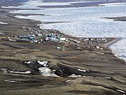
Located on the southern shores of Banks Island
-
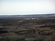
This site was closed and abandoned years ago
-
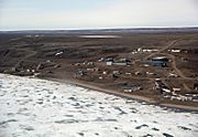
Sachs Harbour's population has been declining and now has approximately 104 residents


See also
 In Spanish: Sachs Harbour para niños
