Husky Lakes facts for kids
Quick facts for kids Husky Lakes |
|
|---|---|
| Eskimo Lakes | |

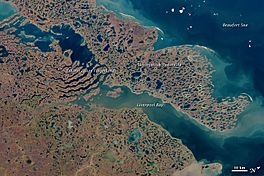
Image of Tuktoyaktuk Peninsula and surrounding bodies of water (north is to the upper right), including the lower Husky Lakes near the top left corner. Both "finger" areas can be seen; the eastern area is labelled.
|
|
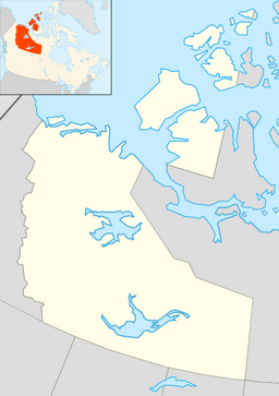
| Location | Northwest Territories, Canada |
| Coordinates | 69°15′N 132°17′W / 69.25°N 132.29°W |
| Native name | Imaryuk Error {{native name checker}}: parameter value is malformed (help) |
| Primary inflows | Sitidgi Creek |
| Primary outflows | Liverpool Bay, Beaufort Sea |
| Catchment area | 9,543 km2 (3,685 sq mi) |
| Basin countries | Canada |
| Surface area | 1,933 km2 (746 sq mi) |
| Average depth | 13 m (43 ft) |
| Max. depth | 100 m (330 ft) |
The Husky Lakes are a group of connected lakes in the Northwest Territories of Canada. These lakes have brackish water, meaning it's a mix of fresh and salty water, like where a river meets the sea. Long ago, they were called the Eskimo Lakes. The Inuvialuit people, who have lived there for a very long time, call them Imaryuk in their language, Inuvialuktun.
Contents
About the Husky Lakes
The Husky Lakes are made up of five connected water areas. They flow towards the northeast. These lakes are located along a natural crack in the Earth's crust called the Eskimo Lakes fault zone.
How the Lakes Connect
The two lower parts of the lakes are surrounded by flooded valleys. These valleys are found between narrow strips of land that look like "fingers." Through the eastern "finger" area, which the Inuvialuit call Singiit, the lakes empty into Liverpool Bay. This bay is part of the Beaufort Sea.
Water Sources and Size
Sitidgi Lake, a freshwater lake to the south, flows into the southernmost part of the Husky Lakes. It connects through a shallow channel called Sitidgi Creek. Together, the Husky Lakes cover a huge area of about 1,933 square kilometers (746 square miles). They also collect water from a much larger area, about 9,543 square kilometers (3,685 square miles).
Depth and Surroundings
On average, the Husky Lakes are about 13 meters (43 feet) deep. The deepest parts can reach up to 100 meters (328 feet). The area around the lakes is north of the tree line. This means there are no tall trees, only the typical plants of the Arctic tundra.
History of the Area
The Husky Lakes region has a long history. It has been home to the Inuvialuit people for many centuries.
Ancient Discoveries
At a place called Saunaktuk, which means "place of bones," scientists found remains from the 14th or 15th century. These remains belonged to Inuvialuit women, elderly people, and children. This discovery matches stories passed down by the Inuvialuit about an attack that happened there long ago.
Life Around the Lakes Today
The area around the Husky Lakes is still very important to the Inuvialuit people. Many Inuvialuit from nearby communities like Tuktoyaktuk and Inuvik rely on the lakes for their way of life.
Traditional Activities
In the spring, fishing is a big part of life. People traditionally catch lake trout, lake whitefish, cod, and pike. Hunting for bear, goose, and duck also happens in the spring. However, hunting for caribou has recently been stopped to help protect the animals.
Seasonal Activities
It can be harder to get around the area in the summer after the ice melts. But this might change because the Dempster Highway has been extended to Tuktoyaktuk. This new road passes close to the western side of the southern lakes. In the fall, people enjoy picking berries like cloudberry, crowberry, blueberry, and cranberry. Hunting ptarmigan is also popular. From late fall through early spring, trapping is a common activity.
Modern Facilities
There are cabins built around the lakes for people to use. There is also a special lodge at Saunaktuk for visitors who want to experience the area.
 | Aaron Henry |
 | T. R. M. Howard |
 | Jesse Jackson |


