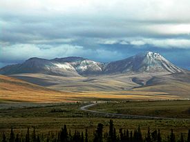
Richardson Mountains facts for kids
Quick facts for kids Richardson Mountains |
|
|---|---|

Dempster Highway crossing the Richardson Mountains
|
|
| Highest point | |
| Elevation | 1,240 m (4,070 ft) |
| Naming | |
| Etymology | Named for Arctic explorer John Richardson |
| Geography | |
| Country | Canada |
| Province | Yukon |
| Range coordinates | 68°10′N 137°00′W / 68.167°N 137.000°W |
| Parent range | Brooks Range |
The Richardson Mountains are a mountain range found in northern Yukon, Canada. They are located west of where the Mackenzie River meets the ocean. These mountains run alongside the northern part of the border between Yukon and the Northwest Territories.
Discovering the Richardson Mountains
The Richardson Mountains are a cool part of Canada's northern landscape. They stretch out in a long line, making up an important natural feature in the Yukon.
Where Are They Located?
These mountains are in a very northern part of Canada, close to the Arctic Circle. They are west of the huge Mackenzie River, which is one of the longest rivers in North America. The mountains also follow the border that separates Yukon from the Northwest Territories. This makes them a landmark for travelers in the region.
Part of a Bigger Mountain Family
You might hear different ideas about which mountain range the Richardson Mountains belong to. Some people think they are part of the Canadian Rockies. However, the Canadian Rockies usually end much further south, near the Liard River.
The Richardson Mountains are actually a smaller part of a much larger mountain system called the Brooks Range. Most of the Brooks Range is located in Alaska, which is west of Canada. So, the Richardson Mountains are like the Canadian extension of this big Alaskan mountain chain. They reach a height of about 1,240 meters (4,068 feet) above sea level.
 | Sharif Bey |
 | Hale Woodruff |
 | Richmond Barthé |
 | Purvis Young |

