
Verkhoyansk Range facts for kids
Quick facts for kids Verkhoyansk Range |
|
|---|---|
| Верхоянский хребет Үөһээ Дьааҥы сис хайата |
|

Aerial view of the Verkhoyansk Mountains
|
|
| Highest point | |
| Peak | Orulgan high point |
| Elevation | 2,409 m (7,904 ft) |
| Dimensions | |
| Length | 1,100 km (680 mi) |
| Geography | |

Verkhoyansk Range
Location in Far Eastern Federal District
|
|
| Country | Russia |
| State | Sakha Republic |
| Parent range | East Siberian System |
| Geology | |
| Orogeny | Alpine orogeny |
| Age of rock | Cretaceous |
| Type of rock | Metamorphic rocks |
The Verkhoyansk Range is a long chain of mountain ranges in the Sakha Republic, Russia. It is located near the town of Verkhoyansk, which is famous for its extremely cold weather. This mountain range is part of the larger East Siberian Mountains.
The Verkhoyansk Range sits right next to where the Eurasian and North American tectonic plates meet. These mountains were formed when the Earth's crust folded, creating an anticline (an upward fold in rock layers).
During the last Ice Age, large glaciers covered the Verkhoyansk Range. Because of this, the mountains in the northern part, like the Orulgan Range, have sharp, jagged peaks and valleys, much like the Alps in Europe.
You can find valuable minerals in these mountains. There are coal, silver, lead, tin, and zinc deposits hidden within the rocks.
Contents
Exploring the Geography of the Verkhoyansk Range
The Verkhoyansk Range stretches for about 1,000 kilometers (600 miles) across Yakutia. It starts in the north near the Buor-Khaya Gulf and runs south. To its west is the flat Central Yakutian Lowland, and to its east is the Chersky Range. In the south, it reaches the Lena Plateau and the Yudoma-Maya Highlands. This mountain system forms a huge curve between the Lena River and Aldan River in the west and the Yana River in the east.
The southeastern part of the Verkhoyansk Range is higher and is called the Suntar-Khayata Range. Sometimes, people consider this a separate mountain system. The highest point of the Verkhoyansk Range itself is an unnamed peak in the Orulgan Range, which stands at 2,409 meters (7,904 feet) tall.
In the past, some parts like the Ulakhan-Bom, Sette-Daban, and Skalisty Range were thought to be separate mountains. However, in 1934, geologists Yuri Alexandrovich Bilibin and Evgeny Sergeyevich Bobin explored the area. They created the first detailed maps and showed that these mountain chains are actually part of the Verkhoyansk Mountain System.
Main Mountain Sections and Peaks
The Verkhoyansk Range is made up of many smaller mountain chains and a plateau. Here are some of them:

- Northern Section (North of the Arctic Circle)
- Kharaulakh Range, highest point 1,429 meters (4,688 feet)
- Tuora Sis, highest point 990 meters (3,250 feet)
- Kunga Range, highest point 439 meters (1,440 feet)
- Dzhardzhan Range, highest point 1,925 meters (6,316 feet)
- Sietinden Range, highest point 1,929 meters (6,329 feet)
- Kular Range, highest point 1,289 meters (4,229 feet)
- Byrandia Range, highest point 1,915 meters (6,283 feet)
- Kuyellyakh Range, highest point 1,483 meters (4,865 feet)
- Southern Section (South of the Arctic Circle)
- Echysky Massif, highest point 2,063 meters (6,768 feet)
- Arkachan Plateau, highest point 1,351 meters (4,432 feet)
- Tagindzhin Range, highest point 2,084 meters (6,837 feet)
- Muosuchan Range, highest point 1,243 meters (4,078 feet)
- Bygyn Range, highest point 1,152 meters (3,780 feet)
- Kuturgin Range, highest point 1,056 meters (3,465 feet)
- Munni Range, highest point 1,784 meters (5,853 feet)
- Kelter Range, highest point 2,002 meters (6,568 feet)
- Sorkin Range, highest point 1,250 meters (4,100 feet)
- Ust-Vilyuy Range, highest point 998 meters (3,274 feet) (close to the Lena River)
- Chochum Range, highest point 1,363 meters (4,472 feet)
- Sordogin Range, highest point 1,352 meters (4,436 feet)
- Khabakh Range, highest point 1,122 meters (3,681 feet) (east)
- Khunkhadin Range, highest point 1,802 meters (5,912 feet) (east)
- Far Southern Section (Part of the greater Verkhoyansk Range, with the Suntar Khayata)
- Kyllakh Range, highest point 901 meters (2,956 feet)
- Ulakhan-Bom, highest point 1,830 meters (6,000 feet)
- Sette-Daban, highest point 2,102 meters (6,896 feet)
- Skalisty Range, highest point 2,017 meters (6,617 feet)
Rivers and Waterways
The Verkhoyansk mountain system acts like a giant wall. It separates the river basins of the Lena River to the west and the Omoloy and Yana rivers to the east. Many rivers flow through deep valleys within the mountains.
Many rivers start in the range and flow west into the Lena River. These include the Kyundyudey, Undyulyung, Begidyan, Sobolokh-Mayan, Menkere, Dzhardzhan, Uel-Siktyakh, Kuranakh-Siktyakh, Byosyuke, Tikyan, Dyanyshka, Lyapiske, Belyanka, Munni, Kele, Tukulan, Tumara, Nuora, and Baray.
To the northeast, rivers like the Kuranakh-Yuryakh, Arga-Yuryakh, Bukhuruk, and Sietinde flow into the Omoloy River. The Tompo River cuts through the southern part of the range. The Aldan River flows to the south, making a wide bend around the mountains.
From the eastern slopes, rivers like the Dulgalakh and Sartang flow. They join to form the Yana River further north. Other rivers on the eastern side include the Bytantay, Nelgese, Derbeke, and Baky.
Because of the very cold climate, rivers in these mountains are usually frozen solid from September until May.
Climate and Plant Life
This region is known for having some of the lowest temperatures ever recorded in places where people live. For most of the year, the mountains are covered in very deep snow.
The Verkhoyansk Range is home to an alpine tundra environment. This means that only tough plants like different kinds of mosses and lichens can grow there. On the smoother slopes, you might find some sparse forests. These forests are mostly made up of larch trees and dwarf Siberian pine.
Images for kids
-
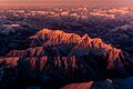
Verkhoyansk Range. Area of rugged ridges.
-
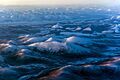
Landscape of the Verkhoyansk Range with smooth mountains and intermontane basins.


See also
 In Spanish: Cordillera Verjoyansk para niños
- List of mountains and hills of Russia
- Chersky Range
