
Amur facts for kids
Quick facts for kids Amur |
|
|---|---|

The river Amur (Heilong Jiang)
|
|

Map of the Amur watershed
|
|
| Other name(s) | ᠰᠠᡥᠠᠯᡳᠶᠠᠨ ᡠᠯᠠ sahaliyan ula 黑龙江 Hēilóng Jiāng Аму́р, Amur |
| Countries | |
| Cities |
|
| Physical characteristics | |
| Main source | Onon-Shilka Khan Khentii Strictly Protected Area, Khentii Province, Mongolia 2,045 m (6,709 ft) 48°48′59″N 108°46′13″E / 48.81639°N 108.77028°E |
| 2nd source | Argun Greater Khingan, Hulunbuir, China 49°56′13″N 122°27′54″E / 49.937°N 122.465°E |
| River mouth | Strait of Tartary Near Nikolayevsk-on-Amur, Khabarovsk Krai, Russia 0 m (0 ft) 52°56′50″N 141°05′02″E / 52.94722°N 141.08389°E |
| Length | 2,824 km (1,755 mi) |
| Width |
|
| Depth |
|
| Discharge (location 2) |
|
| Discharge (location 3) |
(Period of data: 1940-2009)8,321 m3/s (293,900 cu ft/s)
|
| Basin features | |
| River system | Strait of Tartary |
| Basin size | 1,855,000 km2 (716,000 sq mi) |
| Tributaries |
|
The Amur River, also known as Heilong Jiang in Chinese, is one of the world's longest rivers. It forms a natural border between the Russian Far East and Northeast China. The Amur River itself is about 2,824 kilometers (1,755 miles) long. If you include its main source river, the Argun, it stretches for an amazing 4,444 kilometers (2,761 miles)!
The river's basin, which is the area of land that drains into it, covers a huge 1,855,000 square kilometers (716,000 square miles). This vast area is home to many different kinds of fish and animals. For example, the kaluga is a giant fish found here, growing up to 5.6 meters (18 feet) long! Other interesting fish include the northern snakehead and Amur pike. You can also find the Amur softshell turtle and beautiful Indian lotus flowers in this region.
Contents
What's in a Name?
The name "Amur" comes from words in Tungusic languages, which are spoken by native groups in Siberia and Northeast Asia. In these languages, "Amur" simply means "river." It's common for rivers to be named after the word for "water" or "river" in many Asian languages. For example, in Korean, "mul" means water, and in Mongolian, "muren" means river. So, "Amur" might mean "Big Water."
The modern Chinese name for the river is Heilongjiang (黑龙江). This means "Black Dragon River." The Manchurian name is Sahaliyan Ula, which also means "Black River." The Mongolian names, Amar mörön and Khar mörön, mean "rest river" and "black river" respectively.
The River's Journey
The Amur River starts in the hills of western Northeast China. It begins where two important rivers, the Shilka and the Argun, meet. This meeting point is about 303 meters (994 feet) above sea level.
From there, the river flows east, creating the border between China and Russia. It makes a big curve to the southeast for about 400 kilometers (250 miles). Along this path, it collects water from many smaller rivers. Near the city of Huma, it is joined by the Huma He.
The Amur then flows south, passing between the Russian city of Blagoveshchensk and the Chinese city of Heihe. Here, it gets much wider as it meets the Zeya River, another major tributary.
The river then turns east and then southeast again after joining the Bureya River. It flows for a long stretch before meeting its largest tributary, the Songhua, near Tongjiang. After this, the Amur turns northeast, heading towards Khabarovsk. Here, it joins the Ussuri River and stops being the border between Russia and China.
Now, the river spreads out into many smaller channels, flowing north-northeast through a wide valley in eastern Russia. It passes cities like Amursk and Komsomolsk-on-Amur. The valley narrows, and the river flows onto plains after joining the Amgun River. Soon after, the Amur turns sharply east and flows into an estuary near Nikolayevsk-on-Amur. About 20 kilometers (12 miles) downstream, it empties into the Strait of Tartary, which leads to the Sea of Okhotsk.
During very rainy years, the Amur river system can even connect with the Kherlen River. This creates a super-long river system of 5,052 kilometers (3,139 miles) all the way to the Sea of Japan.
Main Rivers Joining the Amur
The Amur River has many rivers flowing into it. Here are some of the largest, listed from where the Amur starts to where it ends:
- Argun (from the right side)
- Shilka (from the left side)
- Huma (from the right side)
- Zeya (from the left side)
- Bureya (from the left side)
- Songhua (from the right side)
- Ussuri (from the right side)
- Amgun (from the left side)
There are also many lakes in the flat areas around the Amur, like Bolon, Khummi, and Udyl.
A Look at History
The Amur River has always been very important to the people living along its banks. Historically, the area around the Amur was divided into two main parts: Outer Manchuria (now part of Russia) and Inner Manchuria (now part of China). The Chinese province of Heilongjiang and the Russian Amur Oblast are both named after the river. The native Manchu people considered the river sacred.
For many centuries, various groups of people lived in the Amur Valley. These included the Tungusic peoples (like the Evenki and Nanai), Mongols (like the Daur), and Nivkhs. For most of these groups, fishing in the Amur was their main way to get food.

In the 13th and 14th centuries, the Mongols, who ruled as the Yuan dynasty, had a small military presence on the lower Amur. Later, in the early 1400s, the Chinese Ming dynasty sent expeditions to the Amur. A leader named Yishiha visited the area several times, building temples and getting the local tribes to agree to be part of the Ming government. However, the Ming presence on the Amur didn't last very long.


Russian explorers, known as Cossacks, arrived in the Amur region in the mid-1600s. They built a fort called Albazin on the upper Amur. At this time, the Manchus were busy conquering China. But later, they focused on their northern lands. They rebuilt the city of Aigun and fought the Russians, leading to the fall of Albazin in 1685. The Treaty of Nerchinsk in 1689 ended the fighting and gave the entire Amur valley to China.

The Amur region remained mostly quiet for the next 150 years. Then, in the mid-1800s, Russians returned. They forced the Manchus to give up all the land north of the river to the Russian Empire with the Treaty of Aigun in 1858. More land east of the Ussuri River was also given to Russia in 1860. The Amur River became a very important border between Russia and China.
Amazing Wildlife
The Amur River is home to at least 123 different kinds of fish! Many of these are from the carp family. There are also many types of salmon. Some fish species are found only in the Amur and a few nearby rivers.
Four types of sturgeon live here: the kaluga, Amur sturgeon, Sakhalin sturgeon, and sterlet. The kaluga and Amur sturgeon are unique to this river. The sterlet was brought here from the Ob River in the 1950s.
Bridges and Tunnels
Crossing the wide Amur River can be a challenge! The very first permanent bridge across the Amur was the Khabarovsk Bridge, finished in 1916. It was about 2,590 meters (8,500 feet) long. This bridge allowed trains on the Trans-Siberian Railway to cross the river all year round, even when it was frozen. In 1941, a railway tunnel was also built.
Later, more bridges were built:
- A combined road and rail bridge at Komsomolsk-on-Amur (1975), about 1,400 meters (4,600 feet) long.
- Another road and rail Khabarovsk Bridge (1999), which is 3,890 meters (12,760 feet) long.

A new railway bridge, the Tongjiang-Nizhneleninskoye railway bridge, was proposed in 2007. This bridge will connect Tongjiang in China with Nizhneleninskoye in Russia. The Chinese part of the bridge was finished in 2016, and work on the Russian side began that same year. The two sides of the bridge met in March 2019, making it a complete structure. It is expected to open for trains soon.
See Also
 In Spanish: Río Amur para niños
- Amuri, Tampere, a Tampere district named after battles at river Amur during the Russo-Japanese war
- Amur cork tree
- Amur maple
- Amur falcon
- Amur leopard
- Amur tiger
- Amur honeysuckle
- Geography of China
- Geography of Russia
- Sino-Soviet border conflict
- Jilin chemical plant explosions 2005
- Home of the Kaluga (Acipenseriformes)
- List of longest undammed rivers
- Sixty-Four Villages East of the Heilong Jiang
- Amur Military Flotilla
Images for kids
-
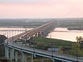
The Khabarovsk Bridge across the Amur, once the longest in Imperial Russia and Eurasia.
-
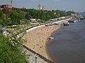
On the Amur in Khabarovsk.


