
Strait of Tartary facts for kids

The Strait of Tartary is a narrow stretch of water in the Pacific Ocean. It is also known by other names like the Tatar Strait or Gulf of Tartary. This strait acts like a watery border, separating the large island of Sakhalin (which belongs to Russia) from the mainland of Asia.
The Strait of Tartary connects two important seas. To the north, it links to the Sea of Okhotsk. To the south, it opens up into the Sea of Japan. This strait is about 900 kilometers (560 miles) long. It's not very deep, usually between 4 and 20 meters (13 to 66 feet). At its narrowest point, it is only about 7.3 kilometers (4.5 miles) wide.
Getting Around the Strait

Since 1973, a special rail ferry has been used to cross the Strait of Tartary. This ferry helps connect two important places. It links the port of Vanino, Khabarovsk Krai on the mainland with Kholmsk on Sakhalin Island. This makes it easier to transport goods and people between the island and the mainland.
Images for kids
-
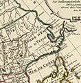
The coasts of the "Channel of Tartary" were explored by La Pérouse in 1787. The land next to it on the west was called "Chinese Tartary" back then.
-
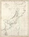
An early 18th-century French map showing the Vries Strait and the Strait of Tartary.

.jpg)
See also
 In Spanish: Estrecho de Tartaria para niños
