
Canyon de Chelly National Monument facts for kids
Quick facts for kids Canyon de Chelly National Monument |
|
|---|---|

Canyon de Chelly, 1904, by Edward S. Curtis
|
|

Canyon de Chelly National Monument
Location in Arizona

Canyon de Chelly National Monument
Location in the United States
|
|
| Location | Apache County, Arizona |
| Nearest city | Chinle |
| Area | 83,840 acres (339.3 km2) |
| Created | April 1, 1931 |
| Visitors | 439,306 (in 2018) |
| Governing body | Bureau of Indian Affairs |
| Website | Canyon de Chelly National Monument |
| NRHP reference No. | 70000066 |
| Added to NRHP | August 25, 1970 |
Canyon de Chelly National Monument is a really special place in northeastern Arizona. It became a national monument on April 1, 1931. This amazing area is located within the Navajo Nation and is part of the Four Corners region.
The monument protects a landscape that has been lived in for a very long time. People have called this place home for thousands of years! It has ruins from ancient tribes like the Ancestral Puebloans and, more recently, the Navajo people. The monument covers about 83,840 acres, which is roughly 131 square miles. It includes three big canyons: de Chelly, del Muerto, and Monument Canyon. These canyons were carved out by streams flowing from the Chuska Mountains.
What makes Canyon de Chelly unique is that the land is not owned by the federal government. Instead, it belongs to the Navajo Tribal Trust. It's one of the most visited national monuments in the United States.
Contents
What's in a Name?
The name Chelly comes from the Navajo language word Tséyiʼ. This word means "rock canyon" or "inside the rock." The Spanish people who explored the area borrowed this Navajo word. Later, English speakers started saying it like "də SHAY."
A Look Back in Time
People have lived in Canyon de Chelly for a very long time. Some Hopi Indians lived there between the 1300s and early 1700s. After that, the Navajo people moved into the canyon from northern New Mexico. Since then, it has been an important home for them.
However, the Navajo people faced many challenges. In 1805, forces led by Lt. Antonio Narbona invaded the canyon. Many Navajo people were killed, and others were captured. Later, in 1863, Col. Kit Carson sent troops into the canyon. They destroyed homes, peach orchards, and crops. This made it very hard for the Navajo to survive. Because of this, many Navajo people had to leave their homes and were moved to a place called Fort Sumner in New Mexico.
Exploring the Canyon
Canyon de Chelly is special because it's the only National Park Service area that is fully owned and managed by a Native American tribe, the Navajo Nation. About 40 Navajo families still live inside the park today.
To protect the canyon and its history, visitors usually need to be with a park ranger or an authorized Navajo guide to go down to the canyon floor. The only exception is the White House Ruin Trail. This trail was open without a fee from August 2 to September 29, 2024. It will open again seasonally in April 2025, with details about times and fees to be announced.

One of the most famous sights in the park is Spider Rock. This amazing sandstone spire rises 750 feet (about 229 meters) from the canyon floor. You can see Spider Rock from the South Rim Drive. For the Navajo people, the taller of the two spires is believed to be the home of Spider Grandmother, an important figure in their stories.
Most visitors explore Canyon de Chelly by driving along the North Rim Drive and South Rim Drive. From these roads, you can stop at different viewpoints to see ancient ruins and cool rock formations in the distance. Deep inside the park is Mummy Cave, which has structures built at different times in history.
If you want a closer look, private Navajo-owned companies offer tours into the canyon. You can go by horseback, hiking, or in a four-wheel-drive vehicle. There is no entrance fee to get into the park itself, but tour companies do charge for their services. As of June 2025, commercial air tours over the canyon are no longer allowed.
You can find places to stay near the canyon in the town of Chinle. The National Monument was added to the National Register of Historic Places on August 25, 1970, recognizing its importance.
Weather in the Canyon
Canyon de Chelly has a cold semi-arid climate. This means it's generally dry, but it can get quite cold. The hottest temperature ever recorded here was 105°F (41°C) on a few different dates, most recently on June 21, 2016. The coldest temperature was a chilly -32°F (-36°C) on January 2, 1919.
| Climate data for Canyon de Chelly, Arizona, 1991–2020 normals, extremes 1908–present | |||||||||||||
|---|---|---|---|---|---|---|---|---|---|---|---|---|---|
| Month | Jan | Feb | Mar | Apr | May | Jun | Jul | Aug | Sep | Oct | Nov | Dec | Year |
| Record high °F (°C) | 70 (21) |
72 (22) |
85 (29) |
90 (32) |
101 (38) |
105 (41) |
105 (41) |
102 (39) |
99 (37) |
90 (32) |
79 (26) |
69 (21) |
105 (41) |
| Mean maximum °F (°C) | 57.3 (14.1) |
64.1 (17.8) |
74.6 (23.7) |
82.6 (28.1) |
91.3 (32.9) |
99.4 (37.4) |
100.9 (38.3) |
96.9 (36.1) |
92.4 (33.6) |
83.4 (28.6) |
69.8 (21.0) |
58.8 (14.9) |
101.5 (38.6) |
| Mean daily maximum °F (°C) | 43.8 (6.6) |
50.6 (10.3) |
60.7 (15.9) |
68.9 (20.5) |
79.0 (26.1) |
90.0 (32.2) |
92.9 (33.8) |
89.7 (32.1) |
82.7 (28.2) |
69.9 (21.1) |
55.5 (13.1) |
43.3 (6.3) |
68.9 (20.5) |
| Daily mean °F (°C) | 31.4 (−0.3) |
37.1 (2.8) |
45.0 (7.2) |
52.4 (11.3) |
61.4 (16.3) |
71.3 (21.8) |
76.5 (24.7) |
74.2 (23.4) |
66.2 (19.0) |
53.7 (12.1) |
41.0 (5.0) |
31.4 (−0.3) |
53.5 (11.9) |
| Mean daily minimum °F (°C) | 19.0 (−7.2) |
23.6 (−4.7) |
29.2 (−1.6) |
35.8 (2.1) |
43.7 (6.5) |
52.5 (11.4) |
60.2 (15.7) |
58.8 (14.9) |
49.8 (9.9) |
37.5 (3.1) |
26.5 (−3.1) |
19.6 (−6.9) |
38.0 (3.3) |
| Mean minimum °F (°C) | 5.2 (−14.9) |
10.3 (−12.1) |
17.1 (−8.3) |
22.9 (−5.1) |
31.3 (−0.4) |
40.1 (4.5) |
51.9 (11.1) |
51.4 (10.8) |
36.1 (2.3) |
24.2 (−4.3) |
12.1 (−11.1) |
5.0 (−15.0) |
1.2 (−17.1) |
| Record low °F (°C) | −32 (−36) |
−22 (−30) |
1 (−17) |
9 (−13) |
10 (−12) |
20 (−7) |
38 (3) |
38 (3) |
23 (−5) |
10 (−12) |
−3 (−19) |
−27 (−33) |
−32 (−36) |
| Average precipitation inches (mm) | 0.76 (19) |
0.73 (19) |
0.65 (17) |
0.48 (12) |
0.51 (13) |
0.27 (6.9) |
1.07 (27) |
1.30 (33) |
0.85 (22) |
0.83 (21) |
0.58 (15) |
0.72 (18) |
8.75 (222.9) |
| Average snowfall inches (cm) | 1.1 (2.8) |
0.9 (2.3) |
0.6 (1.5) |
0.1 (0.25) |
0.0 (0.0) |
0.0 (0.0) |
0.0 (0.0) |
0.0 (0.0) |
0.0 (0.0) |
0.1 (0.25) |
0.6 (1.5) |
1.5 (3.8) |
4.9 (12.4) |
| Average precipitation days (≥ 0.01 in) | 4.4 | 4.7 | 4.1 | 3.1 | 2.8 | 1.7 | 6.3 | 6.9 | 5.2 | 4.1 | 3.5 | 4.8 | 51.6 |
| Average snowy days (≥ 0.1 in) | 0.8 | 0.7 | 0.7 | 0.1 | 0.0 | 0.0 | 0.0 | 0.0 | 0.0 | 0.1 | 0.4 | 1.0 | 3.8 |
| Source 1: NOAA | |||||||||||||
| Source 2: National Weather Service | |||||||||||||
Images for kids
-
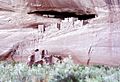
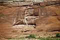
White House Ruin
-
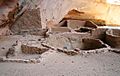
Antelope House Ruin
-
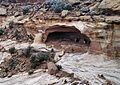
Massacre Cave
-
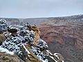
Snow at the canyon, with Mummy Cave in the background
-
First Ruin
-
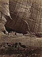
White House Ruin, Timothy H. O'Sullivan, 1873
-
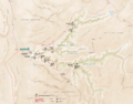
Park map


.jpg)


See also
 In Spanish: Cañón de Chelly para niños
