
National Register of Historic Places listings in Apache County, Arizona facts for kids

Apache County in Arizona is home to many special places that are listed on the National Register of Historic Places. This register is like a special list of buildings, sites, and objects that are important in American history, architecture, archaeology, engineering, or culture. When a place is on this list, it means it's recognized for its unique value and efforts are made to protect it.
In Apache County, there are 33 places on this important list. Seven of these are even more special because they are also National Historic Landmarks. This means they are considered to be of national importance. Let's explore some of these amazing historic sites!
Historic Places in Apache County
| Name on the Register | Image | Date listed | Location | City or town | Description | |
|---|---|---|---|---|---|---|
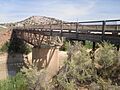
| 1 | Allentown Bridge |
 |
(#88001617) |
Indian Route 9402 over the Puerco River at milepost 9.1 35°16′51″N 109°09′16″W / 35.280833°N 109.154444°W |
Houck | This historic bridge helps people cross the Puerco River. It was built to last and is an important part of the local transportation history. |
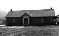
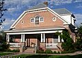
| 2 | Alpine Elementary School |
 |
(#97000369) |
11 and 12 County Road 2052, near its junction with U.S. Route 180 33°50′51″N 109°08′27″W / 33.8475°N 109.140833°W |
Alpine | This school building has been a place of learning for many years in the small town of Alpine. It shows how communities built schools for their children. |
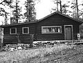
| 3 | Butterfly Lodge |
 |
(#92000686) |
Forest Rd. 245 east of State Route 373 in the Apache National Forest 34°01′08″N 109°26′57″W / 34.018889°N 109.449167°W |
Greer | Butterfly Lodge is a historic cabin nestled in the beautiful Apache National Forest. It offers a glimpse into early life in this scenic area. |
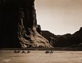
| 4 | Canyon de Chelly National Monument |
 |
(#70000066) |
Eastern side of Chinle 36°08′21″N 109°20′05″W / 36.139167°N 109.334722°W |
Chinle | This amazing national monument protects ancient cliff dwellings and canyons. It has been home to Native American people for thousands of years. |
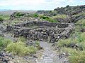
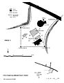
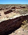
| 5 | Casa Malpais Site |
 |
(#66000936) |
Address restricted 34°09′33″N 109°17′24″W / 34.159167°N 109.29°W |
Springerville | Casa Malpais is an ancient Native American village. It includes a large ceremonial kiva and unique rock carvings. It's a National Historic Landmark. |
| 6 | Chinle Franciscan Mission Historic District |
 |
(#07000506) |
Indian Service Route 7 across road and southwest of the Chinle Judicial complex and Police Station Coordinates missing |
Chinle | This district includes buildings from a historic mission. Missions often played a big role in the history of communities in the Southwest. |
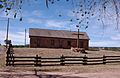
| 7 | Colter Ranch Historic District |
 |
(#93000626) |
Junction of 4th St. and School Bus Rd. 34°06′24″N 109°19′11″W / 34.106667°N 109.319722°W |
Eagar | The Colter Ranch shows what a historic ranching operation looked like. It's an important part of the agricultural history of the area. |
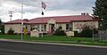
| 8 | Eagar School |
 |
(#93000624) |
174 S. Main St. 34°06′29″N 109°17′31″W / 34.107918°N 109.292079°W |
Eagar | This old school building now serves as the Eagar police station. It's a great example of how historic buildings can be reused. |
| 9 | Eagar Townsite Historic District |
 |
(#93000625) |
Roughly bounded by Central Ave., Main St., 1st Ave. and Eagar St. 2nd Ave, and Harless St., 3rd Ave., and Eagar St. 34°06′45″N 109°17′25″W / 34.1125°N 109.290278°W |
Eagar | This district includes many historic buildings that show the growth and development of the town of Eagar. |
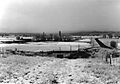
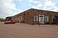
| 11 | Hubbell Trading Post National Historic Site |
 |
(#66000167) |
Western side of Ganado Coordinates missing |
Ganado | This trading post was a very important meeting place for the Navajo people and traders. It has been operating since 1878. |
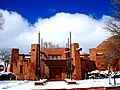
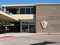
| 18 | Navajo Nation Council Chamber |
 |
(#04001155) |
W008-013 Circle Boulevard 35°40′58″N 109°02′54″W / 35.682778°N 109.048333°W |
Window Rock | This building is where the Navajo Nation government meets. It's a very important symbol of self-governance for the Navajo people. |
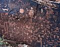
| 19 | Newspaper Rock Petroglyphs Archeological District |
 |
(#76000185) |
Address restricted 34°57′43″N 109°47′57″W / 34.962066°N 109.799059°W |
Adamana | This site has many ancient rock carvings, called petroglyphs. They tell stories and record events from people who lived here long ago. |
| 20 | Painted Desert Community Complex Historic District |
 |
(#05000284) |
One Park Rd. 35°04′06″N 109°46′50″W / 35.068333°N 109.780556°W |
Petrified Forest National Park | This complex of buildings was designed in a special architectural style. It helps visitors explore the beautiful Painted Desert. |
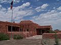
| 21 | Painted Desert Inn |
 |
(#87001421) |
West of Navajo in Petrified Forest National Park, off Interstate 40 35°05′03″N 109°47′06″W / 35.084167°N 109.785°W |
Navajo | The Painted Desert Inn is a historic lodge within Petrified Forest National Park. It's known for its unique design and amazing views. It's a National Historic Landmark. |
| 23 | Puerco Ruin and Petroglyphs |
 |
(#76000208) |
Address restricted 34°58′29″N 109°47′39″W / 34.974823°N 109.794089°W |
Adamana | This site includes ancient pueblo ruins and more petroglyphs. It shows how early people lived and created art in this region. |
| 26 | Sage Memorial Hospital School of Nursing |
(#09000082) |
Ganado Mission Coordinates missing |
Ganado | This school was important for training nurses, especially Native American nurses. It played a big role in healthcare history in the region. It's a National Historic Landmark. | |
| 27 | St. Michael's Mission |
 |
(#75000335) |
North of Window Rock off State Route 264 35°38′44″N 109°05′53″W / 35.645556°N 109.098056°W |
Window Rock | St. Michael's Mission has been a center for religious and community life. It has served the Navajo people for many years. |
Former Historic Listings
Sometimes, places are removed from the National Register if they are destroyed or lose their historic importance. Here are a couple of places that were once listed in Apache County:
| Name on the Register | Image | Date listed | Date removed | Location | City or town | Summary | |
|---|---|---|---|---|---|---|---|
| 1 | Barth Hotel |
(#75000334) |
|
187 E. Commercial St. |
St. Johns | The Barth Hotel was a historic hotel in St. Johns. It was removed from the list in 1985. | |
| 2 | Petrified Forest Bridge |
(#88001616) |
|
Petrified Forest Park Rd. over Rio Puerco |
Navajo vicinity | This bridge was once part of the Petrified Forest Park Road. It was delisted in 1998. |
Images for kids
-
Allentown Bridge
-
Alpine Elementary School
-
Butterfly Lodge
-
Canyon de Chelly National Monument
-
Casa Malpais Site
-
Chinle Franciscan Mission Historic District
-
Colter Ranch Historic District
-
Eagar School
-
Eagar Townsite Historic District
-
Hubbell Trading Post National Historic Site
-
Navajo Nation Council Chamber
-
Newspaper Rock Petroglyphs Archeological District
-
Painted Desert Community Complex Historic District
-
Painted Desert Inn
-
Puerco Ruin and Petroglyphs
-
St. Michael's Mission
