
Puerco River facts for kids
Quick facts for kids Puerco RiverRio Puerco |
|
|---|---|

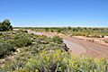
Flowing near Puerco Pueblo,
in Petrified Forest National Park |
|

The mouth of the Puerco River on the Little Colorado River, northeast-central Arizona
|
|
| Country | United States |
| State | Arizona, New Mexico |
| Region | Colorado Plateau |
| Physical characteristics | |
| Main source | near Hosta Butte McKinley County, New Mexico 7,930 ft (2,420 m) 35°34′33″N 108°10′52″W / 35.57583°N 108.18111°W |
| River mouth | Little Colorado River near Holbrook, Navajo County, Arizona 5,102 ft (1,555 m) 34°53′20″N 110°07′17″W / 34.88889°N 110.12139°W |
| Length | 167 mi (269 km) |
| Basin features | |
| Basin size | 2,654 sq mi (6,870 km2) |
The Puerco River, also known as Rio Puerco, is a river that flows through parts of New Mexico and Arizona. It's like a smaller river that feeds into a bigger one called the Little Colorado River. This river travels through very dry lands, including the colorful Painted Desert.
Contents
What's in a Name?
The Puerco River is sometimes called the Rio Puerco of the West. This helps people tell it apart from another river, the Rio Puerco of the East. Both rivers start in the same general area, but they flow in different directions.
The word "Puerco" means pig in Spanish. However, it can also mean dirty or filthy. In the southwestern United States, the name is better understood as Dirty River or Muddy River. This is because the river often carries a lot of silt and mud, especially after rains.
River Journey and Features
The Puerco River is the main river that flows into the Little Colorado River. The Little Colorado River then joins the much larger Colorado River. The Puerco River is about 167 miles (269 km) long. It drains an area of about 2,654 square miles (6,870 km2).
For most of the year, the Puerco River is an intermittent river. This means it doesn't always have water flowing in it. Its average water flow is very low, usually less than 70 cubic feet per second (2.0 m3/s). This is because the area it flows through is very dry. Often, it looks like a wide, braided dry streambed, called a wash, with little or no water. However, during heavy rainstorms, big flash floods can happen.
Where the River Starts and Flows

The Puerco River begins on the western side of the Continental Divide of the Americas. This is near Hosta Butte in McKinley County, New Mexico. It first flows north, then turns west. It travels through a wide desert valley with tall, rocky cliffs and buttes on its sides.
The river passes under Interstate 40. Near Gallup, another stream called the South Fork Puerco River joins it. For most of its path, Interstate 40 and the BNSF Railway tracks follow the river's valley.
The Puerco River then crosses into Apache County, Arizona. It flows past towns like Houck, Sanders, and Chambers. It also goes through the middle of Petrified Forest National Park. Here, another stream called Lithodendron Wash flows into it. Finally, the river flows southwest and joins the Little Colorado River near Holbrook.
How Much Water Flows?
The United States Geological Survey (USGS) measures the water flow of the Puerco River. They have a special station about 1 mile (1.6 km) southwest of Chambers in Arizona. Between 1971 and 2009, the most water recorded flowing was 17,800 cubic feet per second (500 m3/s) on September 30, 1971. Many times, the water flow was zero, meaning the river was completely dry. This measurement is for an area of about 2,156 square miles (5,580 km2).
River Concerns: Water Quality
For many years, Navajo people living in the Puerco River Valley have used the river's surface water for their livestock, like cows and sheep.
From the 1950s to the early 1980s, the Puerco River often had water flowing continuously. This was because it was fed by wastewater from uranium mines upstream. Some of this water was not treated, which led to water pollution.
A Major Spill Event
One of the most serious spills in U.S. history happened near the Puerco River. This was the Church Rock uranium mill spill on July 16, 1979. A pond at the Church Rock uranium mill, which belonged to United Nuclear Corporation, broke open. About 93 million gallons (350,000 m3) of radioactive, acidic waste water flowed into the North Fork of the Puerco River.
This spill contaminated about 250 acres (100 ha) of land and up to 50 miles (80 km) of the Puerco River. It also released about 1,100 short tons (1,000 t) of uranium mine waste. This event had a big impact on the environment and the people who relied on the river.
Images for kids
-
Flowing near Puerco Pueblo, in Petrified Forest National Park
-
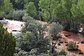
The Puerco River in McKinley County, New Mexico.
