Rio Puerco (Rio Grande tributary) facts for kids
Quick facts for kids Rio Puerco |
|
|---|---|

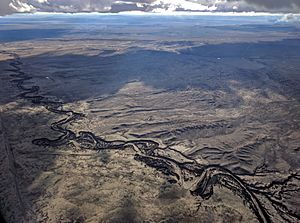
The Rio Puerco where it crosses the eastern edge of the Tohajiilee Indian Reservation, just west of Albuquerque's West Mesa, Petroglyph National Monument, and Double Eagle II Airport
|
|

Map of the Rio Grande watershed, showing the Rio Puerco joining the Rio Grande near Albuquerque.
|
|
| Country | United States |
| State | New Mexico |
| County | Socorro, Valencia, Bernalillo, Sandoval, Rio Arriba |
| Physical characteristics | |
| Main source | San Pedro Peaks Nacimiento Mountains 10,500 ft (3,200 m) 36°7′28″N 106°49′53″W / 36.12444°N 106.83139°W |
| River mouth | Rio Grande 4,711 ft (1,436 m) 34°22′23″N 106°50′33″W / 34.37306°N 106.84250°W |
| Length | 230 mi (370 km) |
| Basin features | |
| Basin size | 7,350 sq mi (19,000 km2) |

The Rio Puerco is a river in New Mexico, United States. It is a branch of the larger Rio Grande river. The Rio Puerco starts in the Nacimiento Mountains and flows for about 230 miles (370 km). It generally flows south before joining the Rio Grande. This meeting point is about 20 miles (32 km) south of Belen. It is also about 50 miles (80 km) south of Albuquerque.
The area of land that drains into the Rio Puerco is called its drainage basin. This basin is very large, covering about 7,350 square miles (19,000 km2). The Rio Puerco is often dry for parts of the year. This means it is an ephemeral river. Its average water flow is about 39.5 cubic feet per second (1.12 m3/s). The highest water flow ever recorded was 5,980 cubic feet per second (169 m3/s) in 1941.
Contents
What Does "Rio Puerco" Mean?
The name Rio Puerco comes from Spanish. While it literally means River of Pigs, in the southwestern United States, it is better understood as Muddy River. This name fits well because the river often carries a lot of mud and dirt.
Where Does the Rio Puerco Flow?
The Rio Puerco begins in the San Pedro Peaks area. This area is part of the Nacimiento Mountains. It is also within the Santa Fe National Forest. The river flows mostly south and southwest. It leaves the mountains near the village of Cuba.
From Cuba, the river continues to flow south. It passes along the west side of the Jemez Indian Reservation. Another stream, Arroyo Chico, joins it from the west. The Rio Puerco then flows past Mesa Prieta. It also goes through the Laguna and Tohajiilee Indian Reservation lands.
Near the border of Bernalillo and Valencia counties, the Rio San Jose joins the Rio Puerco. The Rio San Jose flows from the west, near Grants. Finally, the Rio Puerco continues south through the Albuquerque Basin. It then meets the Rio Grande.
A Look at the Rio Puerco's Past
The Rio Puerco Valley has a rich history. Long ago, many ancestral Puebloan people lived here. These were the ancestors of today's Pueblo people. Many of them came to this valley after the Chacoan civilization declined.
In the 1860s, the US Army worked to make the area safer. They pushed back Native American groups who were raiding. This allowed Hispano settlers to move west of the Rio Grande. These settlers came from places like Albuquerque and Bernalillo. They quickly settled on any land near the Rio Puerco that could be farmed.
However, by the mid-1900s, the land changed. Many years of too much overgrazing by livestock caused problems. Also, frequent flash floods damaged the area. The land became very difficult to live on. Because of this, many people left the Rio Puerco valley.
Why is the Rio Puerco So Muddy?
The Rio Puerco carries a lot of sediment, which is like dirt and sand. This makes it a major source of suspended particles in the water. The Rio Puerco Basin is one of the most eroded river basins in the western United States. This erosion is largely due to overgrazing.
The USGS (United States Geological Survey) studies the river. They collect samples of the sediment in the water. In 2008, they recorded a very high amount of sediment on one day. The river carried a huge amount of dirt, showing how muddy it can get.
 | Chris Smalls |
 | Fred Hampton |
 | Ralph Abernathy |

